Latest earthquakes near Timor-Leste today
Complete overview of the latest earthquakes near the country Timor-Leste, updated every minute. Did you feel an earthquake today in Timor-Leste? If an earthquake is happening right now near Timor-Leste (also known as East Timor), it will show up within minutes.
Recent Timor-Leste Earthquake News
These are the latest articles published related to earthquakes occurring near Timor-Leste. Check our Earthquake News section for a complete overview of articles written on earthquakes near Timor-Leste and elsewhere.
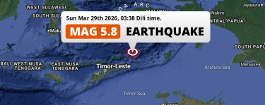 Mar 29, 2026 03:38AM
Significant M5.9 Earthquake hit in the Banda Sea 363km from Atambua (Indonesia) on Sunday Night.
Mar 29, 2026 03:38AM
Significant M5.9 Earthquake hit in the Banda Sea 363km from Atambua (Indonesia) on Sunday Night.
Timor-Leste Earthquake Statistics
Average
A total of 2583 earthquakes with a magnitude of four or above have struck within 300 km (186 mi) of Timor-Leste in the past 10 years. This comes down to a yearly average of 258 earthquakes per year, or 21 per month. On average an earthquake will hit near Timor-Leste roughly every 1 days.
A relatively large number of earthquakes occurred near Timor-Leste in 2025. A total of 323 earthquakes (mag 4+) were detected within 300 km of Timor-Leste that year. The strongest had a 6.2 magnitude.

Magnitude Distribution
The table below visualizes the distribution of all earthquakes that occurred within 300km of Timor-Leste in the past 10 years. No earthquakes with a magnitude of 8 or above have occurred near Timor-Leste during this time. Usually, higher magnitudes are less common than lower magnitudes. Small earthquakes with a magnitude below 4 on the Richter scale have been omitted from this overview.
| Magnitude | Earthquakes | Percentage |
|---|---|---|
| Mag. 4 | 2462 | 95.32% |
| Mag. 5 | 111 | 4.3% |
| Mag. 6 | 9 | 0.35% |
| Mag. 7 | 1 | 0.04% |
| Mag. 8 | 0 | 0.0% |
| Mag. 9 | 0 | 0.0% |
| Mag. 10 | 0 | 0.0% |
Strongest earthquakes near Timor-Leste
The strongest recent earthquake of the past 10 years near Timor-Leste occurred on Dec 30, 2021 03:25 local time (Asia/Dili timezone). It had a magnitude of 7.3 and struck 126 kilometers (78 mi) north-northeast of Lospalos, at a depth of 166 km. Discover more strong earthquakes near Timor-Leste in the list below.
A longer time ago, a MAG-7.5 earthquake struck on Nov 12, 2004 06:26, 90 kilometers (56 mi) north-northeast of Dili. It is the strongest earthquake near Timor-Leste in the past 126 years (Our data goes back to January 1st, 1900).
In the table below you will find the strongest earthquakes that occurred near Timor-Leste in the past 10 years. You can use the tabs to find the heaviest historic earthquakes since the year 1900 or within a specific year or distance from Timor-Leste.
Earthquakes by region of Timor-Leste
Click the links below for earthquake reports for regions in Timor-Leste.
Frequently Asked Questions
These questions are commonly asked in relation to earthquakes occurring near Timor-Leste.
When was the last earthquake in Timor-Leste?
A 2.8 magnitude earthquake hit near Timor-Leste on the evening of April 1, 2026 at 19:38 local time (Asia/Dili). The center of this earthquake was located 257km west of Dili at a depth of 33km under water in the Sawu Sea. Check the list on our website for any earthquakes occurring near Timor-Leste in the past hours.
What was the strongest earthquake near Timor-Leste?
A 7.5 magnitude earthquake hit near Timor-Leste on the morning of November 12, 2004 at 06:26 local time (Asia/Dili). The center of this earthquake was located 90km west-northwest of Dili at a depth of 10km under water in the Banda Sea. This is the strongest earthquake that occurred near Timor-Leste since the year 1900.
How often do earthquakes occur near Timor-Leste?
In the past 10 years, 2583 earthquakes with a magnitude of four or higher occurred within a 300 kilometer range from Timor-Leste. This averages to 258 earthquakes yearly, or one earthquake every 1 days.
