
In the evening of Saturday February 8th, 2025, an unusually powerful M7.6 earthquake hit in the Caribbean Sea 209 kilometer from George Town, Cayman Islands. The USGS has indicated there is a potential risk at tsunami's following this earthquake. Honduras is also near its epicenter.
Felt the earthquake? Share this article: 


Earthquake Summary
This earthquake hit under water in the Caribbean Sea, 209 kilometers (130 mi) off the coast of Cayman Islands, 209 kilometer south-southwest of George Town. The center of this earthquake had a very shallow depth of 10 km. Shallow earthquakes usually have a larger impact than earthquakes deep in the earth.
| Date and Time: | Feb 8, 2025 18:23 (Cayman Time) - Feb 8, 2025 23:23 Universal Time. |
|---|---|
| Location: | 209 km SSW of George Town, Cayman Islands. Coordinates 17°41'25"N 82°24'54"W. |
| Map: |  Map of area around epicenter. Click to open in Google Maps. |
| Magnitude: | MAG 7.6 Detected by 12 stations. Maximum Error Range ±0.028 . |
| Depth: | 10 km (6 mi) A very shallow depth. |
| Max. Intensity: | V
Moderate On the Modified Mercalli Scale. |
| Tsunami Risk: | Potential tsunami risk The USGS has indicated there is a potential risk at tsunami's following this earthquake. Always stay cautious - More info here. |
Potential tsunami risk
There is a potential tsunami risk in the aftermath of this earthquake, immediately evacuate to higher grounds away from coastal areas and monitor advice from local authorities. The US Geographic Survey organization has indicated a potential risk for tsunami's following this earthquake.
Tsunami Risk Factors
| Factor | Under Sea? | MAG-6.5 or stronger? | Shallow depth? |
|---|---|---|---|
| Explanation | Almost all tsunami's are caused by earthquakes with their epicenter under sea or very near the sea. However stay cautious in coastal areas as earthquakes on land may cause landslides into sea, potentially still causing a local tsunami. | Under MAG 6.5: Very unlikely to cause a tsunami. MAG 6.5 to 7.5: Destructive tsunami's do occur, but are uncommon. Likely to observe small sea level changes. MAG 7.6+: Earthquakes with these magnitudes might produce destructive tsunami's. |
Most destructive tsunami's are caused by shallow earthquakes with a depth between 0 and 100km under the surface of the earth. Deeper tsunami's are unlikely to displace to ocean floor. |
| This Earthquake | This earthquake appears to have struck under the sea. | This earthquake had a magnitude of 7.6. Earthquakes of this strength could trigger a tsunami. | This earthquake occurred at a depth of of 10 km (6 mi). Earthquakes this shallow could trigger a tsunami. |
Minimal impact predicted
The US Geographic Survey (USGS) describes the impact of this earthquake as follows:
Some buildings damaged and power outages reported in parts of Honduras and Belize. A 3 cm tsunami observed at Isla Mujeres, Mexico.
Based on scientific estimates by the USGS, the risk of high fatalities for this earthquake is classified at level GREEN (low). They expect an 65% likelyhood of between 0 and 1 fatalities, and a 96% chance that the number of fatalities falls no higher than 10.
The USGS classifies the economic impact of this earthquake at level GREEN (low). They expect an 68% likelyhood of between 0 and 1 million US Dollars in economic damage and impact, and a 98% chance that the economic impact of this earthquake falls no higher than 10 million USD.
Roughly 5.7 million people exposed to shaking
The USGS has published a report estimating the number of people exposed to this earthquake. Acoording to their analysis, roughly 5.7 million have been exposed to shaking at an MMI level of II or higher.
An estimated 7,500 people were exposed to level V. At this level, moderate shaking and very light damage can be expected. Intensity level III was experienced by the majority of people (around 2.9 million). In their region, weak shaking and probably no damage can be expected.
People in 7 countries have been exposed to shaking. In Honduras , around 2.3 million people, with impact levels up to V (moderate shaking, very light damage). In Nicaragua , around 0.8 million people. In Mexico , around 1.3 million people. In Cuba, Jamaica and Cayman Islands, a smaller number of people were exposed.
| People | MMI Level | Shaking | Damage |
|---|---|---|---|
| 0 | I |
Not noticable | None |
| 3,140 | II |
Very weak | None |
| 2,946,000 | III |
Weak | Probably none |
| 2,718,000 | IV |
Light | Likely none |
| 7,500 | V |
Moderate | Very light |
| 0 | VI |
Strong | Light |
| 0 | VII |
Very Strong | Moderate |
| 0 | VIII |
Severe | Moderate to heavy |
| 0 | IX |
Violent | Heavy |
| 0 | X |
Extreme | Very heavy |
Nearby towns and cities
This earthquake struck within proximity of multiple countries. Cayman Islands and Honduras are both within 300km distance of its epicenter. Futher away, this earthquake may also have been felt in Nicaragua, Jamaica, Cuba, Mexico, Colombia, Belize and Guatemala.
The closest significant population center near the earthquake is George Town in George Town, Cayman Islands. George Town is located 209 kilometer (130 mi) south-southwest of the epicenter. The intensity of shaking and damage in George Town is estimated to be around level IV on the Modified Mercalli Intensity scale (light shaking, likely no damage).
Multiple major population centers exist within 300km of the earthquake that struck today. Havana is located 605 km to the north (intensity unknown, possibly low). Kingston is located 596 km to the east (intensity unknown, possibly low). Managua is located 743 km to the south-southwest (intensity unknown, possibly low).
A complete list of nearby places is included below. Estimated intensity data (MMI) sourced from a shake-map published by the US Geographic Survey is shown where available (cities without data probably experienced little impact).
Overview of nearby places
| Distance | Place | Intensity (MMI) |
|---|---|---|
| 209 km (130 mi) NNE from epicenter |
George Town George Town, Cayman Islands. |
IV
Light |
| 420 km (261 mi) SSW from epicenter |
Puerto Cabezas North Caribbean Coast, Nicaragua. |
|
| 442 km (275 mi) WSW from epicenter |
Tocoa Colón, Honduras. |
|
| 457 km (284 mi) E from epicenter |
Savanna-la-Mar Westmoreland, Jamaica. |
|
| 468 km (291 mi) N from epicenter |
Nueva Gerona Isla de la Juventud, Cuba. |
|
| 483 km (300 mi) E from epicenter |
Montego Bay St. James, Jamaica. |
|
| 512 km (318 mi) WSW from epicenter |
La Ceiba Atlántida, Honduras. |
|
| 521 km (324 mi) E from epicenter |
Mandeville Manchester, Jamaica. |
|
| 523 km (325 mi) NNE from epicenter |
Trinidad Sancti Spíritus, Cuba. |
|
| 527 km (327 mi) SW from epicenter |
Juticalpa Olancho, Honduras. |
|
| 536 km (333 mi) NNE from epicenter |
Cienfuegos Cienfuegos, Cuba. |
|
| 542 km (337 mi) NNW from epicenter |
Pinar del Río Pinar del Río, Cuba. |
|
| 547 km (340 mi) NNW from epicenter |
Consolación del Sur Pinar del Río, Cuba. |
|
| 548 km (341 mi) E from epicenter |
May Pen Clarendon, Jamaica. |
|
| 563 km (350 mi) N from epicenter |
San Cristobal Aremisa, Cuba. |
|
| 565 km (351 mi) NNE from epicenter |
Sancti Spíritus Sancti Spíritus, Cuba. |
|
| 568 km (353 mi) N from epicenter |
Güira de Melena Aremisa, Cuba. |
|
| 569 km (354 mi) WNW from epicenter |
Cozumel Quintana Roo, Mexico. |
|
| 571 km (355 mi) N from epicenter |
Artemisa Aremisa, Cuba. |
|
| 573 km (356 mi) S from epicenter |
San Andrés San Andres y Providencia, Colombia. |
|
| 574 km (357 mi) N from epicenter |
Güines Mayabeque, Cuba. |
|
| 577 km (359 mi) SW from epicenter |
Jalapa Nueva Segovia, Nicaragua. |
|
| 579 km (360 mi) E from epicenter |
Spanish Town Saint Catherine, Jamaica. |
|
| 581 km (361 mi) NNE from epicenter |
Colón Matanzas, Cuba. |
|
| 584 km (363 mi) NNE from epicenter |
Santa Clara Villa Clara, Cuba. |
|
| 586 km (364 mi) E from epicenter |
Portmore Saint Catherine, Jamaica. |
|
| 589 km (366 mi) WNW from epicenter |
Playa del Carmen Quintana Roo, Mexico. |
|
| 591 km (367 mi) N from epicenter |
Boyeros Havana, Cuba. |
|
| 595 km (370 mi) N from epicenter |
Arroyo Naranjo Havana, Cuba. |
|
| 596 km (370 mi) E from epicenter |
Kingston Kingston, Jamaica. |
|
| 597 km (371 mi) E from epicenter |
New Kingston St. Andrew, Jamaica. |
|
| 599 km (372 mi) NE from epicenter |
Ciego de Ávila Ciego de Ávila, Cuba. |
|
| 600 km (373 mi) N from epicenter |
Diez de Octubre Havana, Cuba. |
|
| 601 km (373 mi) N from epicenter |
San Miguel del Padrón Havana, Cuba. |
|
| 601 km (373 mi) N from epicenter |
Matanzas Matanzas, Cuba. |
|
| 602 km (374 mi) N from epicenter |
Cerro Havana, Cuba. |
|
| 603 km (375 mi) SW from epicenter |
Danlí El Paraíso, Honduras. |
|
| 604 km (375 mi) N from epicenter |
Guanabacoa Havana, Cuba. |
|
| 605 km (376 mi) N from epicenter |
La Habana Vieja Havana, Cuba. |
|
| 605 km (376 mi) NW from epicenter |
Cancún Quintana Roo, Mexico. |
|
| 605 km (376 mi) N from epicenter |
Havana Havana, Cuba. |
|
| 606 km (377 mi) N from epicenter |
Centro Habana Havana, Cuba. |
|
| 608 km (378 mi) N from epicenter |
Ciudad Camilo Cienfuegos Havana, Cuba. |
|
| 608 km (378 mi) N from epicenter |
Cárdenas Matanzas, Cuba. |
|
| 608 km (378 mi) N from epicenter |
Alamar Havana, Cuba. |
|
| 613 km (381 mi) W from epicenter |
Belize City Corozal, Belize. |
|
| 625 km (388 mi) NE from epicenter |
Camagüey Camagüey, Cuba. |
|
| 628 km (390 mi) WSW from epicenter |
El Progreso Yoro, Honduras. |
|
| 629 km (391 mi) W from epicenter |
Chetumal Quintana Roo, Mexico. |
|
| 630 km (391 mi) ENE from epicenter |
Manzanillo Granma, Cuba. |
|
| 633 km (393 mi) WSW from epicenter |
Choloma Cortés, Honduras. |
|
| 640 km (398 mi) SW from epicenter |
Jinotega Jinotega, Nicaragua. |
|
| 645 km (401 mi) WSW from epicenter |
San Pedro Sula Cortés, Honduras. |
|
| 647 km (402 mi) SW from epicenter |
Somoto Madriz, Nicaragua. |
|
| 648 km (403 mi) SSW from epicenter |
Bluefields South Caribbean Coast, Nicaragua. |
|
| 649 km (403 mi) SW from epicenter |
Matagalpa Matagalpa, Nicaragua. |
|
| 651 km (405 mi) SW from epicenter |
Tegucigalpa Francisco Morazán, Honduras. |
|
| 652 km (405 mi) W from epicenter |
Orange Walk Orange Walk, Belize. |
|
| 663 km (412 mi) SW from epicenter |
Estelí Estelí, Nicaragua. |
|
| 664 km (413 mi) WSW from epicenter |
Comayagua Comayagua, Honduras. |
|
| 676 km (420 mi) ENE from epicenter |
Bayamo Granma, Cuba. |
|
| 676 km (420 mi) SW from epicenter |
La Paz La Paz, Honduras. |
|
| 677 km (421 mi) SSW from epicenter |
Boaco Boaco, Nicaragua. |
|
| 679 km (422 mi) ENE from epicenter |
Las Tunas Las Tunas, Cuba. |
|
| 693 km (431 mi) WSW from epicenter |
Santa Bárbara Santa Bárbara, Honduras. |
|
| 693 km (431 mi) WNW from epicenter |
Valladolid Yucatán, Mexico. |
|
| 693 km (431 mi) WSW from epicenter |
Puerto Barrios Izabal, Guatemala. |
|
| 697 km (433 mi) SSW from epicenter |
Juigalpa Chontales, Nicaragua. |
|
| 706 km (439 mi) SW from epicenter |
Somotillo Chinandega, Nicaragua. |
|
| 707 km (439 mi) SW from epicenter |
Ciudad Choluteca Choluteca, Honduras. |
|
| 708 km (440 mi) W from epicenter |
San Ignacio Cayo, Belize. |
|
| 718 km (446 mi) SW from epicenter |
San Lorenzo Valle, Honduras. |
|
| 737 km (458 mi) ENE from epicenter |
Holguín Holguín, Cuba. |
|
| 740 km (460 mi) ENE from epicenter |
Santiago de Cuba Santiago de Cuba, Cuba. |
|
| 743 km (462 mi) SSW from epicenter |
Managua Managua, Nicaragua. |
|
| 745 km (463 mi) SSW from epicenter |
Granada Granada, Nicaragua. |
|
| 748 km (465 mi) SSW from epicenter |
Masaya Masaya, Nicaragua. |
|
| 750 km (466 mi) SW from epicenter |
Nagarote León, Nicaragua. |
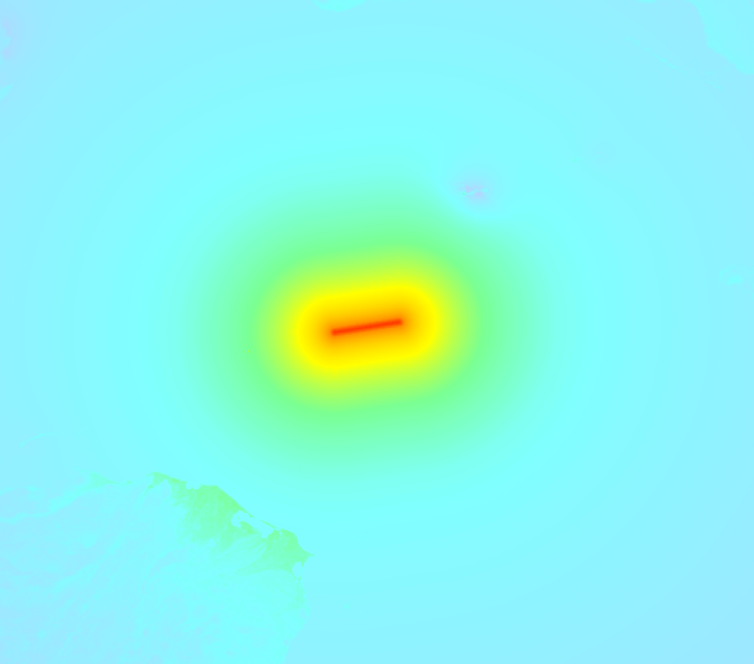
Earthquake Intensity Map
The maximum intensity (MMI Scale) caused by this earthquake is V. The map below shows in which areas this earthquake was the most and least impactful. It is based on data from the US Geographic Survey.
Shaking reported by 331 people in 16 countries
People that feel an earthquake may report their experience to the US Geographic Survey. Currently, 331 people have reported shaking in 60 places in 16 countries (Trinidad and Tobago, Venezuela, Dominican Republic, Barbados, Belize, Cayman Islands, Guatemala, Haiti, Honduras, Colombia, Jamaica, Mexico, Montserrat, Panama, Costa Rica, Cuba).We keep updating this article as more ground reports become available. You may report that you felt this earthquake here.
Places with most reports:
- Cancún, Quintana Roo, Mexico: 50 people.
- Bonfil, Quintana Roo, Mexico: 34 people.
- George Town, Grand Cayman, Cayman Islands: 33 people.
- Playa del Carmen, Quintana Roo, Mexico: 26 people.
- Isla Mujeres, Quintana Roo, Mexico: 14 people.
- Bodden Town, Grand Cayman, Cayman Islands: 13 people.
- Tegucigalpa, Distrito Central, Honduras: 12 people.
- Cozumel, Quintana Roo, Mexico: 12 people.
- West Bay, Grand Cayman, Cayman Islands: 12 people.
- Belize, Belize, Belize: 10 people.
7 Aftershocks detected
Since this main shock, 7 smaller aftershocks were detected. A 4.8 magnitude earthquake hit 10 hrs later 56 km (35 mi) west-southwest of this earthquake.
Overview of foreshocks and aftershocks
| Classification | Magnitude | When | Where |
|---|---|---|---|
| Main Shock This Earthquake |
M 7.6 |
Feb 8, 2025 18:23 (Cayman Time) | - |
| Aftershock | M 4.8 |
28 mins later Feb 8, 2025 18:51 (Cayman Time) | 82 km (51 mi) W from Main Shock. |
| Aftershock | M 4.3 |
44 mins later Feb 8, 2025 19:06 (Cayman Time) | 59 km (37 mi) WSW from Main Shock. |
| Aftershock | M 4.3 |
53 mins later Feb 8, 2025 19:16 (Cayman Time) | 42 km (26 mi) ENE from Main Shock. |
| Aftershock | M 4.2 |
60 mins later Feb 8, 2025 19:23 (Cayman Time) | 42 km (26 mi) W from Main Shock. |
| Aftershock | M 4.6 |
9 hrs later Feb 9, 2025 03:21 (Cayman Time) | 38 km (24 mi) W from Main Shock. |
| Aftershock | M 4.8 |
10 hrs later Feb 9, 2025 04:14 (Cayman Time) | 56 km (35 mi) WSW from Main Shock. |
| Aftershock | M 4.3 |
2 days later Feb 10, 2025 17:31 (Cayman Time) | 75 km (47 mi) WSW from Main Shock. |
More earthquakes coming?
Aftershocks are usually at least 1 order of magnitude less strong than main shocks. The more time passes, the smaller the chance and likely strength of any potential aftershocks.
The chance that a significant earthquake like this one is followed by an even larger earthquake is not so large. On average, scientists estimate a 94% chance that a major earthquake will not be followed by an even larger one. It is still adviced to be aware of this risk
Read: How to Stay Safe during an Earthquake (cdc.gov).This is an unusually powerful earthquake
No earthquake of this strength has struck this region for a long time. Our data goes back 10 years, and no earthquakes measuring a magnitude of 7.6 or higher have been detected within 300 km (186 mi) of this epicenter.
Sources
Last updated 09/04/25 07:08 (). As more information on this earthquake becomes available this article will be updated. This article is automatically composed based on data originating from multiple sources.
- US Geographic Society (USGS): Earthquake us7000pcdl
- European-Mediterranean Seismological Centre (EMSC): Earthquake 20250208_0000374
- Geonames.org: World Cities Database
- Google Maps: Static API
- Earthquakelist.org: Historic Earthquakes Database
Share this article:
