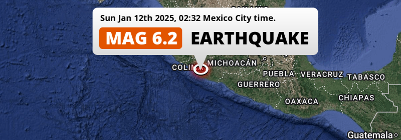
A strong M6.2 earthquake struck under land 71 kilometer from Tecomán in Mexico in the night of Sunday January 12th, 2025. Around 5.4 million people have been exposed to shaking.
Felt the earthquake? Share this article: 


Earthquake Summary
The earthquake struck on land in Mexico, 71 kilometer (44 mi) south-east of Tecomán in Colima. The center of this earthquake had a quite shallow depth of 39 km. Shallow earthquakes usually have a larger impact than earthquakes deep in the earth.
| Date and Time: | Jan 12, 2025 02:32 (Mexico City Time) - Jan 12, 2025 08:32 Universal Time. |
|---|---|
| Location: | 71 km SE of Tecomán, Colima, Mexico. Coordinates 18°30'7"N 103°21'47"W. |
| Map: | 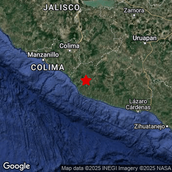 Map of area around epicenter. Click to open in Google Maps. |
| Magnitude: | MAG 6.2 Detected by 96 stations. Maximum Error Range ±0.032 . |
| Depth: | 39 km (24 mi) A quite shallow depth. |
| Max. Intensity: | VII
Very Strong On the Modified Mercalli Scale. |
| Tsunami Risk: | Tsunami very unlikely While this was a shallow earthquake in a coastal area, it appears to have occurred under land (20 km from the sea) with a magnitude that is usually not strong enough to cause tsunami's. Always stay cautious - More info here. |
Minimal impact predicted
The US Geographic Survey (USGS) describes the impact of this earthquake as follows:
Two people injured at Coahuayula. At least 25 homes and several buildings damaged in the Coalcoman de Vazquez Pallares area. Landslides blocked a road between Colima and Manzanillo.
Based on scientific estimates by the USGS, the risk of high fatalities for this earthquake is classified at level GREEN (low). They expect an 65% likelyhood of between 0 and 1 fatalities, and a 96% chance that the number of fatalities falls no higher than 10.
The USGS classifies the economic impact of this earthquake at level GREEN (low). They expect an 99% likelyhood of between 0 and 1 million US Dollars in economic damage and impact.
Roughly 5.4 million people exposed to shaking
This earthquake may have been felt by around 5.4 million people. That is the expected population size of the area exposed to a level of shaking of II or higher on the Modified Mercalli scale according to the USGS.
An estimated 8,770 people were exposed to level VI. At this level, strong shaking and probably light damage can be expected. The majority of people (roughly 2.7 million) live in an area exposed to level IV, where light shaking and likely no damage is expected. All exposure to shaking was within the borders of Mexico .
| People | MMI Level | Shaking | Damage |
|---|---|---|---|
| 0 | I |
Not noticable | None |
| 0 | II |
Very weak | None |
| 2,197,000 | III |
Weak | Probably none |
| 2,737,000 | IV |
Light | Likely none |
| 504,300 | V |
Moderate | Very light |
| 8,770 | VI |
Strong | Light |
| 0 | VII |
Very Strong | Moderate |
| 0 | VIII |
Severe | Moderate to heavy |
| 0 | IX |
Violent | Heavy |
| 0 | X |
Extreme | Very heavy |
Nearby towns and cities
This earthquake may have been felt in Mexico . Located 71 kilometer (44 mi) south-east of the epicenter of this earthquake, Tecomán (Colima, Mexico) is the nearest significant population center. The intensity of shaking and damage in Tecomán is estimated to be around level V on the Modified Mercalli Intensity scale (moderate shaking, very light damage).
Major cities near this earthquake: Guadalajara is located 241 km to the north (intensity unknown, possibly low). Zapopan is located 247 km to the north (intensity unknown, possibly low). León de los Aldama is located 341 km to the north-northeast (intensity unknown, possibly low).
An overview of nearby towns and cities is available in the overview below. If places don't have intensity data available, it likely means the experienced impact in those places was fairly small.
Overview of nearby places
| Distance | Place | Intensity (MMI) |
|---|---|---|
| 71 km (44 mi) NW from epicenter |
Tecomán Colima, Mexico. |
V
Moderate |
| 80 km (50 mi) NW from epicenter |
Ciudad de Armería Colima, Mexico. |
IV
Light |
| 92 km (57 mi) NNW from epicenter |
Colima Colima, Mexico. |
V
Moderate |
| 93 km (58 mi) NE from epicenter |
Tepalcatepec Michoacán, Mexico. |
IV
Light |
| 94 km (58 mi) NNW from epicenter |
Ciudad de Villa de Álvarez Colima, Mexico. |
V
Moderate |
| 117 km (73 mi) N from epicenter |
Tuxpan Jalisco, Mexico. |
IV
Light |
| 124 km (77 mi) WNW from epicenter |
Manzanillo Colima, Mexico. |
V
Moderate |
| 124 km (77 mi) ENE from epicenter |
Apatzingán Michoacán, Mexico. |
IV
Light |
| 125 km (78 mi) N from epicenter |
Zapotiltic Jalisco, Mexico. |
IV
Light |
| 132 km (82 mi) N from epicenter |
Tamazula de Gordiano Jalisco, Mexico. |
IV
Light |
| 133 km (83 mi) ESE from epicenter |
Guacamayas Michoacán, Mexico. |
IV
Light |
| 133 km (83 mi) ESE from epicenter |
La Orilla Michoacán, Mexico. |
IV
Light |
| 134 km (83 mi) ESE from epicenter |
Ciudad Lázaro Cárdenas Michoacán, Mexico. |
IV
Light |
| 134 km (83 mi) N from epicenter |
Ciudad Guzmán Jalisco, Mexico. |
IV
Light |
| 146 km (91 mi) ENE from epicenter |
Nueva Italia de Ruiz Michoacán, Mexico. |
IV
Light |
| 151 km (94 mi) NE from epicenter |
Peribán de Ramos Michoacán, Mexico. |
IV
Light |
| 151 km (94 mi) WNW from epicenter |
Cihuatlán Jalisco, Mexico. |
IV
Light |
| 153 km (95 mi) NE from epicenter |
Los Reyes de Salgado Michoacán, Mexico. |
IV
Light |
| 155 km (96 mi) N from epicenter |
Sayula Jalisco, Mexico. |
IV
Light |
| 171 km (106 mi) NE from epicenter |
Uruapan Michoacán, Mexico. |
IV
Light |
| 171 km (106 mi) NNW from epicenter |
El Grullo Jalisco, Mexico. |
III
Weak |
| 176 km (109 mi) NW from epicenter |
Autlán de Navarro Jalisco, Mexico. |
IV
Light |
| 179 km (111 mi) NNE from epicenter |
Jiquílpan de Juárez Michoacán, Mexico. |
III
Weak |
| 186 km (116 mi) NNE from epicenter |
Sahuayo de Morelos Michoacán, Mexico. |
IV
Light |
| 188 km (117 mi) NE from epicenter |
Paracho de Verduzco Michoacán, Mexico. |
III
Weak |
| 193 km (120 mi) N from epicenter |
Zacoalco de Torres Jalisco, Mexico. |
IV
Light |
| 196 km (122 mi) NE from epicenter |
Jacona de Plancarte México, Mexico. |
III
Weak |
| 198 km (123 mi) N from epicenter |
Jocotepec Jalisco, Mexico. |
III
Weak |
| 200 km (124 mi) N from epicenter |
Chapala Jalisco, Mexico. |
III
Weak |
| 200 km (124 mi) NE from epicenter |
Zamora Michoacán, Mexico. |
IV
Light |
| 214 km (133 mi) ESE from epicenter |
Ixtapa-Zihuatanejo Guerrero, Mexico. |
III
Weak |
| 215 km (134 mi) NNE from epicenter |
Ocotlán Jalisco, Mexico. |
|
| 216 km (134 mi) ENE from epicenter |
Pátzcuaro Michoacán, Mexico. |
III
Weak |
| 220 km (137 mi) NE from epicenter |
Zacapú Michoacán, Mexico. |
IV
Light |
| 221 km (137 mi) NE from epicenter |
Zacapu Michoacán, Mexico. |
III
Weak |
| 224 km (139 mi) N from epicenter |
Hacienda Santa Fe Jalisco, Mexico. |
|
| 236 km (147 mi) N from epicenter |
Tonalá Jalisco, Mexico. |
|
| 238 km (148 mi) N from epicenter |
Tlaquepaque Jalisco, Mexico. |
|
| 241 km (150 mi) N from epicenter |
Guadalajara Jalisco, Mexico. |
|
| 247 km (153 mi) N from epicenter |
Zapopan Jalisco, Mexico. |
|
| 248 km (154 mi) NE from epicenter |
La Piedad Michoacán, Mexico. |
|
| 265 km (165 mi) ENE from epicenter |
Morelia Michoacán, Mexico. |
|
| 265 km (165 mi) NNE from epicenter |
Tepatitlán de Morelos Jalisco, Mexico. |
|
| 306 km (190 mi) NW from epicenter |
Puerto Vallarta Jalisco, Mexico. |
|
| 320 km (199 mi) NE from epicenter |
Irapuato Guanajuato, Mexico. |
|
| 323 km (201 mi) N from epicenter |
Nochistlán de Mejía Zacatecas, Mexico. |
|
| 341 km (212 mi) NNE from epicenter |
León de los Aldama Guanajuato, Mexico. |
|
| 349 km (217 mi) NE from epicenter |
Celaya Guanajuato, Mexico. |
|
| 371 km (231 mi) NNW from epicenter |
Tepic Nayarit, Mexico. |
|
| 389 km (242 mi) NE from epicenter |
Santiago de Querétaro Querétaro, Mexico. |
|
| 392 km (244 mi) NNE from epicenter |
Aguascalientes Aguascalientes, Mexico. |
|
| 400 km (249 mi) ENE from epicenter |
Toluca México, Mexico. |
Earthquake Intensity Map
The maximum intensity (MMI Scale) caused by this earthquake is VI. The map below shows in which areas this earthquake was the most and least impactful. It is based on data from the US Geographic Survey.

Shaking reported by 636 people
People that feel an earthquake may report their experience to the US Geographic Survey. Currently, 636 people have reported shaking in 84 places, all within Mexico.We keep updating this article as more ground reports become available. You may report that you felt this earthquake here.
Places with most reports:
- Puerto Vallarta, Jalisco, Mexico: 235 people.
- Bucerías, Nayarit, Mexico: 71 people.
- Mexico City, Distrito Federal, Mexico: 43 people.
- San Patricio, Jalisco, Mexico: 41 people.
- Guadalajara, Jalisco, Mexico: 38 people.
- Zapopan, Jalisco, Mexico: 20 people.
- Manzanillo, Colima, Mexico: 16 people.
- Ajijic, Jalisco, Mexico: 14 people.
- Ixtapa, Jalisco, Mexico: 14 people.
- Colima, Colima, Mexico: 11 people.
51 Aftershocks detected
After this earthquake struck, 51 smaller aftershocks occurred. A 4.9 magnitude earthquake hit 2 hrs later 31 km (19 mi) north-east of this earthquake.
In the days before this main shock, 2 smaller foreshocks were detected. Nearby this earthquake a foreshock struck 2 days earlier. It measured a magnitude of 3.5
Overview of foreshocks and aftershocks
| Classification | Magnitude | When | Where |
|---|---|---|---|
| Foreshock | M 3.3 |
2 days earlier Jan 10, 2025 03:00 (Mexico City Time) | 48 km (30 mi) ENE from Main Shock. |
| Foreshock | M 3.5 |
2 days earlier Jan 10, 2025 13:51 (Mexico City Time) | 41 km (25 mi) S from Main Shock. |
| Main Shock This Earthquake |
M 6.2 |
Jan 12, 2025 02:32 (Mexico City Time) | - |
| Aftershock | M 4.0 |
12 mins later Jan 12, 2025 02:45 (Mexico City Time) | 20 km (12 mi) SE from Main Shock. |
| Aftershock | M 4.8 |
46 mins later Jan 12, 2025 03:18 (Mexico City Time) | 21 km (13 mi) NE from Main Shock. |
| Aftershock | M 3.3 |
2 hrs later Jan 12, 2025 04:09 (Mexico City Time) | 8 km (5 mi) WSW from Main Shock. |
| Aftershock | M 3.0 |
2 hrs later Jan 12, 2025 04:21 (Mexico City Time) | 16 km (10 mi) SW from Main Shock. |
| Aftershock | M 3.2 |
2 hrs later Jan 12, 2025 04:24 (Mexico City Time) | 30 km (18 mi) ENE from Main Shock. |
| Aftershock | M 3.1 |
2 hrs later Jan 12, 2025 04:27 (Mexico City Time) | 22 km (14 mi) WSW from Main Shock. |
| Aftershock | M 3.5 |
2 hrs later Jan 12, 2025 04:31 (Mexico City Time) | 13 km (8 mi) SSW from Main Shock. |
| Aftershock | M 4.9 |
2 hrs later Jan 12, 2025 04:46 (Mexico City Time) | 31 km (19 mi) NE from Main Shock. |
| Aftershock | M 4.3 |
2 hrs later Jan 12, 2025 04:53 (Mexico City Time) | 33 km (21 mi) E from Main Shock. |
| Aftershock | M 3.8 |
2 hrs later Jan 12, 2025 04:58 (Mexico City Time) | 5 km (2.9 mi) ENE from Main Shock. |
| Aftershock | M 4.0 |
5 hrs later Jan 12, 2025 07:26 (Mexico City Time) | 25 km (15 mi) ENE from Main Shock. |
| Aftershock | M 3.8 |
12 hrs later Jan 12, 2025 14:26 (Mexico City Time) | 6 km (4 mi) ENE from Main Shock. |
| Aftershock | M 3.7 |
12 hrs later Jan 12, 2025 14:52 (Mexico City Time) | 5 km (3 mi) E from Main Shock. |
| Aftershock | M 3.5 |
13 hrs later Jan 12, 2025 15:08 (Mexico City Time) | 5 km (3 mi) W from Main Shock. |
| Aftershock | M 3.5 |
13 hrs later Jan 12, 2025 15:12 (Mexico City Time) | 11 km (7 mi) WSW from Main Shock. |
| Aftershock | M 3.3 |
13 hrs later Jan 12, 2025 15:16 (Mexico City Time) | 38 km (24 mi) ENE from Main Shock. |
| Aftershock | M 3.6 |
13 hrs later Jan 12, 2025 15:56 (Mexico City Time) | 8 km (5 mi) SSW from Main Shock. |
| Aftershock | M 3.6 |
14 hrs later Jan 12, 2025 16:32 (Mexico City Time) | 5 km (3 mi) SSW from Main Shock. |
| Aftershock | M 3.3 |
14 hrs later Jan 12, 2025 16:43 (Mexico City Time) | 38 km (24 mi) WSW from Main Shock. |
| Aftershock | M 4.1 |
21 hrs later Jan 12, 2025 23:53 (Mexico City Time) | 10 km (6 mi) S from Main Shock. |
| Aftershock | M 3.0 |
1 day later Jan 13, 2025 03:46 (Mexico City Time) | 8 km (5 mi) ENE from Main Shock. |
| Aftershock | M 3.4 |
1 day later Jan 13, 2025 04:06 (Mexico City Time) | 6 km (3 mi) SSW from Main Shock. |
| Aftershock | M 3.1 |
1 day later Jan 13, 2025 04:10 (Mexico City Time) | 15 km (9 mi) WSW from Main Shock. |
| Aftershock | M 3.0 |
1 day later Jan 13, 2025 04:13 (Mexico City Time) | 10 km (6 mi) S from Main Shock. |
| Aftershock | M 3.6 |
1 day later Jan 13, 2025 04:34 (Mexico City Time) | 7 km (4 mi) NE from Main Shock. |
| Aftershock | M 3.5 |
1 day later Jan 13, 2025 04:48 (Mexico City Time) | 12 km (8 mi) ENE from Main Shock. |
| Aftershock | M 4.0 |
1 day later Jan 13, 2025 10:17 (Mexico City Time) | 10 km (6 mi) E from Main Shock. |
| Aftershock | M 3.4 |
1 day later Jan 13, 2025 13:35 (Mexico City Time) | 19 km (12 mi) WSW from Main Shock. |
| Aftershock | M 3.2 |
1 day later Jan 13, 2025 13:49 (Mexico City Time) | 40 km (25 mi) ENE from Main Shock. |
| Aftershock | M 3.3 |
1 day later Jan 13, 2025 13:58 (Mexico City Time) | 23 km (14 mi) WSW from Main Shock. |
| Aftershock | M 3.4 |
1 day later Jan 13, 2025 14:09 (Mexico City Time) | 37 km (23 mi) ENE from Main Shock. |
| Aftershock | M 3.1 |
2 days later Jan 13, 2025 14:33 (Mexico City Time) | 31 km (19 mi) NW from Main Shock. |
| Aftershock | M 3.8 |
2 days later Jan 13, 2025 14:56 (Mexico City Time) | 1.2 km (0.7 mi) NNE from Main Shock. |
| Aftershock | M 3.9 |
2 days later Jan 13, 2025 15:11 (Mexico City Time) | 6 km (4 mi) ESE from Main Shock. |
| Aftershock | M 3.5 |
2 days later Jan 13, 2025 15:17 (Mexico City Time) | 30 km (19 mi) W from Main Shock. |
| Aftershock | M 3.7 |
2 days later Jan 13, 2025 15:21 (Mexico City Time) | 7 km (4 mi) S from Main Shock. |
| Aftershock | M 3.8 |
2 days later Jan 13, 2025 15:50 (Mexico City Time) | 12 km (7 mi) SSE from Main Shock. |
| Aftershock | M 3.2 |
2 days later Jan 13, 2025 16:09 (Mexico City Time) | 8 km (5 mi) SSE from Main Shock. |
| Aftershock | M 3.9 |
2 days later Jan 13, 2025 16:55 (Mexico City Time) | 6 km (3 mi) SSE from Main Shock. |
| Aftershock | M 4.1 |
2 days later Jan 13, 2025 23:33 (Mexico City Time) | 6 km (4 mi) S from Main Shock. |
| Aftershock | M 3.4 |
2 days later Jan 14, 2025 03:25 (Mexico City Time) | 1.9 km (1.2 mi) WSW from Main Shock. |
| Aftershock | M 3.2 |
2 days later Jan 14, 2025 03:31 (Mexico City Time) | 8 km (5 mi) SW from Main Shock. |
| Aftershock | M 3.2 |
2 days later Jan 14, 2025 03:41 (Mexico City Time) | 4 km (2.4 mi) NE from Main Shock. |
| Aftershock | M 3.3 |
2 days later Jan 14, 2025 04:07 (Mexico City Time) | 8 km (5 mi) S from Main Shock. |
| Aftershock | M 3.6 |
2 days later Jan 14, 2025 04:49 (Mexico City Time) | 4 km (2.3 mi) SSW from Main Shock. |
| Aftershock | M 3.7 |
2 days later Jan 14, 2025 13:37 (Mexico City Time) | 25 km (16 mi) WSW from Main Shock. |
| Aftershock | M 3.7 |
2 days later Jan 14, 2025 13:55 (Mexico City Time) | 21 km (13 mi) WSW from Main Shock. |
| Aftershock | M 3.5 |
2 days later Jan 14, 2025 14:25 (Mexico City Time) | 2.5 km (1.6 mi) S from Main Shock. |
| Aftershock | M 3.2 |
3 days later Jan 14, 2025 14:33 (Mexico City Time) | 13 km (8 mi) SE from Main Shock. |
| Aftershock | M 3.2 |
3 days later Jan 14, 2025 15:54 (Mexico City Time) | 9 km (6 mi) S from Main Shock. |
| Aftershock | M 3.1 |
3 days later Jan 14, 2025 16:58 (Mexico City Time) | 39 km (24 mi) WSW from Main Shock. |
More earthquakes coming?
The risk of aftershocks decreases rapidly over time. Usually, aftershocks are at least one order of magnitude lower than a main shock.
It's always adviced to be cautious of the risk of a larger shock following any significant earthquake, however this risk is fairly small. There is a roughly 94 percent change that no larger main shock will follow in the days following this earthquake.
Read: How to Stay Safe during an Earthquake (cdc.gov).Earthquakes like this are common in the region
Earthquakes of this strength occur quite regularly in the region. This is the strongest earthquake to hit since September 22nd, 2022, when a 6.8 magnitude earthquake hit 51 km (31 mi) further east-southeast. An even stronger magnitude 7.6 earthquake struck on September 19th, 2022.
In total, 3 earthquakes with a magnitude of 6.2 or higher have been registered within 300km (186 mi) of this epicenter in the past 10 years. This comes down to an average of once every 3 years.
Tsunami very unlikely
While MAG-6.5+ earthquakes may cause tsunami's, it appears that the epicenter of this earthquake hit under land. In addition, the reported depth is deeper than 100km, making the risk of a tsunami even less likely. However always stay cautious and monitor advice from local authorities.
Tsunami Risk Factors
| Factor | Under Sea? | MAG-6.5 or stronger? | Shallow depth? |
|---|---|---|---|
| Explanation | Almost all tsunami's are caused by earthquakes with their epicenter under sea or very near the sea. However stay cautious in coastal areas as earthquakes on land may cause landslides into sea, potentially still causing a local tsunami. | Under MAG 6.5: Very unlikely to cause a tsunami. MAG 6.5 to 7.5: Destructive tsunami's do occur, but are uncommon. Likely to observe small sea level changes. MAG 7.6+: Earthquakes with these magnitudes might produce destructive tsunami's. |
Most destructive tsunami's are caused by shallow earthquakes with a depth between 0 and 100km under the surface of the earth. Deeper tsunami's are unlikely to displace to ocean floor. |
| This Earthquake | This earthquake appears to have struck on land near a coastal area (20 km from the sea). | Not this earthquake. This earthquake had a magnitude of 6.2. Earthquakes of this strength are unlikely to trigger a tsunami. |
This earthquake occurred at a depth of of 39 km (24 mi). Earthquakes this shallow could trigger a tsunami. |
Sources
Last updated 13/03/25 07:08 (). As more information on this earthquake becomes available this article will be updated. This article is automatically composed based on data originating from multiple sources.
- US Geographic Society (USGS): Earthquake us6000pjig
- European-Mediterranean Seismological Centre (EMSC): Earthquake 20250112_0000092
- Geonames.org: World Cities Database
- Google Maps: Static API
- Earthquakelist.org: Historic Earthquakes Database
Share this article:
