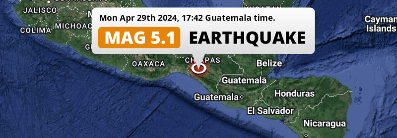
Under land 4 kilometer from Villaflores in Mexico, a significant MAG-5.1 earthquake occurred in the evening of Monday April 29th, 2024. Guatemala is also near its epicenter.
Felt the earthquake? Share this article: 


Earthquake Summary
The earthquake struck on land in Mexico, 4 kilometer (2 mi) south-southeast of Villaflores in Chiapas. The center of this earthquake had an intermediate depth of 143 km.
| Date and Time: | Apr 29, 2024 18:42 (Mexico City Time) - Apr 29, 2024 23:42 Universal Time. |
|---|---|
| Location: | 4 km SSE of Villaflores, Chiapas, Mexico. Coordinates 16°11'58"N 93°15'10"W. |
| Map: | 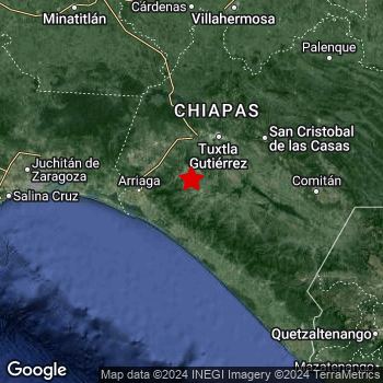 Map of area around epicenter. Click to open in Google Maps. |
| Magnitude: | MAG 5.1 Detected by 21 stations. Maximum Error Range ±0.068 . |
| Depth: | 143 km (89 mi) An intermediate depth. |
| Tsunami Risk: | Tsunami very unlikely Tsunami's are usually caused by MAG-6.5+ earthquakes, less than 100km shallow, and with an epicenter under sea. Neither of this seems to be the case. Always stay cautious - More info here. |
Nearby towns and cities
2 countries can be found within 300km of the epicenter of this earthquake: Mexico and Guatemala .
Villaflores in Chiapas, Mexico is the nearest significant place from the epicenter. The earthquake occurred 4 kilometer (2 mi) south-southeast of Villaflores.
Multiple large cities are in proximity of today's earthquake. Tuxtla is located 64 km to the north-northeast. San Cristóbal de las Casas is located 88 km to the north-east. Villahermosa is located 202 km to the north.
The table below provides an overview of all places in proximity of today's earthquake.
Overview of nearby places
| Distance | Place |
|---|---|
| 4 km (2 mi) NNW from epicenter |
Villaflores Chiapas, Mexico. |
| 50 km (31 mi) NNE from epicenter |
Suchiapa Chiapas, Mexico. |
| 55 km (34 mi) WSW from epicenter |
Tonalá Chiapas, Mexico. |
| 57 km (35 mi) S from epicenter |
Pijijiapan Chiapas, Mexico. |
| 62 km (39 mi) NNE from epicenter |
Chiapa de Corzo Chiapas, Mexico. |
| 64 km (40 mi) NNE from epicenter |
Tuxtla Chiapas, Mexico. |
| 64 km (40 mi) NNW from epicenter |
Ocozocoautla de Espinosa Chiapas, Mexico. |
| 67 km (42 mi) N from epicenter |
Berriozábal Chiapas, Mexico. |
| 69 km (43 mi) W from epicenter |
Arriaga Chiapas, Mexico. |
| 73 km (45 mi) NW from epicenter |
Cintalapa de Figueroa Chiapas, Mexico. |
| 75 km (47 mi) ENE from epicenter |
Venustiano Carranza Chiapas, Mexico. |
| 88 km (55 mi) NE from epicenter |
San Cristóbal de las Casas Chiapas, Mexico. |
| 91 km (57 mi) ENE from epicenter |
Teopisca Chiapas, Mexico. |
| 93 km (58 mi) SSE from epicenter |
Mapastepec Chiapas, Mexico. |
| 96 km (60 mi) ENE from epicenter |
Las Rosas Chiapas, Mexico. |
| 119 km (74 mi) E from epicenter |
Comitán Chiapas, Mexico. |
| 133 km (83 mi) ESE from epicenter |
Comalapa Chiapas, Mexico. |
| 136 km (85 mi) E from epicenter |
Las Margaritas Chiapas, Mexico. |
| 142 km (88 mi) SE from epicenter |
Motozintla Chiapas, Mexico. |
| 145 km (90 mi) SE from epicenter |
Huixtla Chiapas, Mexico. |
| 146 km (91 mi) ENE from epicenter |
Ocosingo Chiapas, Mexico. |
| 146 km (91 mi) NE from epicenter |
Yajalón Chiapas, Mexico. |
| 154 km (96 mi) NNE from epicenter |
Teapa Tabasco, Mexico. |
| 175 km (109 mi) ESE from epicenter |
Jacaltenango Huehuetenango, Guatemala. |
| 178 km (111 mi) SE from epicenter |
Cacahoatán Chiapas, Mexico. |
| 179 km (111 mi) SE from epicenter |
Tapachula Chiapas, Mexico. |
| 180 km (112 mi) NNE from epicenter |
Río de Teapa Tabasco, Mexico. |
| 182 km (113 mi) N from epicenter |
Huimanguillo Tabasco, Mexico. |
| 186 km (116 mi) N from epicenter |
Reforma Chiapas, Mexico. |
| 187 km (116 mi) NNE from epicenter |
Macuspana Tabasco, Mexico. |
| 187 km (116 mi) N from epicenter |
Playas del Rosario Tabasco, Mexico. |
| 190 km (118 mi) W from epicenter |
Juchitán de Zaragoza Oaxaca, Mexico. |
| 199 km (124 mi) NE from epicenter |
Palenque Chiapas, Mexico. |
| 201 km (125 mi) N from epicenter |
Cárdenas Tabasco, Mexico. |
| 202 km (126 mi) N from epicenter |
Villahermosa Tabasco, Mexico. |
| 207 km (129 mi) W from epicenter |
Salina Cruz Oaxaca, Mexico. |
| 210 km (130 mi) NNW from epicenter |
Las Choapas Veracruz, Mexico. |
| 210 km (130 mi) SE from epicenter |
San Pedro Sacatepéquez San Marcos, Guatemala. |
| 213 km (132 mi) W from epicenter |
Santo Domingo Tehuantepec Oaxaca, Mexico. |
| 214 km (133 mi) ESE from epicenter |
Huehuetenango Huehuetenango, Guatemala. |
| 223 km (139 mi) SE from epicenter |
Coatepeque Quetzaltenango, Guatemala. |
| 229 km (142 mi) N from epicenter |
Comalcalco Tabasco, Mexico. |
| 236 km (147 mi) NNW from epicenter |
Agua Dulce Veracruz, Mexico. |
| 239 km (149 mi) SE from epicenter |
San Francisco El Alto Totonicapán, Guatemala. |
| 240 km (149 mi) SE from epicenter |
Quetzaltenango Quetzaltenango, Guatemala. |
| 244 km (152 mi) NW from epicenter |
Minatitlán Veracruz, Mexico. |
| 248 km (154 mi) SE from epicenter |
Totonicapán Totonicapán, Guatemala. |
| 250 km (155 mi) SE from epicenter |
Retalhuleu Retalhuleu, Guatemala. |
| 251 km (156 mi) NNW from epicenter |
Coatzacoalcos Veracruz, Mexico. |
| 263 km (163 mi) NW from epicenter |
Acayucan Veracruz, Mexico. |
| 264 km (164 mi) SE from epicenter |
Mazatenango Suchitepeque, Guatemala. |
| 269 km (167 mi) ESE from epicenter |
Chichicastenango Quiché, Guatemala. |
| 273 km (170 mi) SE from epicenter |
Sololá Sololá, Guatemala. |
| 290 km (180 mi) ESE from epicenter |
Tecpán Guatemala Chimaltenango, Guatemala. |
| 294 km (183 mi) SE from epicenter |
Tiquisate Escuintla, Guatemala. |
Shaking reported by 2 people
People that feel an earthquake may report their experience to the US Geographic Survey. Currently, 2 people have reported shaking in 2 places in Mexico.We keep updating this article as more ground reports become available. You may report that you felt this earthquake here.
Places with most reports:
- Tuxtla Gutiérrez, Chiapas, Mexico: 1 person.
- Tlalnepantla, México, Mexico: 1 person.
5 Aftershocks detected
Since this main shock, 5 smaller aftershocks were detected. At a distance of 83 km (51 mi) west-northwest of this earthquake, an aftershock struck 2 days later. It measured a magnitude of 4.2
In the days before this main shock, 2 smaller foreshocks were detected. Nearby this earthquake a foreshock struck 3 days earlier. It measured a magnitude of 3.8
Overview of foreshocks and aftershocks
| Classification | Magnitude | When | Where |
|---|---|---|---|
| Foreshock | M 3.8 |
3 days earlier Apr 27, 2024 05:29 (Mexico City Time) | 47 km (29 mi) ESE from Main Shock. |
| Foreshock | M 3.7 |
1 day earlier Apr 28, 2024 17:12 (Mexico City Time) | 97 km (60 mi) WSW from Main Shock. |
| Main Shock This Earthquake |
M 5.1 |
Apr 29, 2024 18:42 (Mexico City Time) | - |
| Aftershock | M 3.9 |
22 hrs later Apr 30, 2024 16:49 (Mexico City Time) | 86 km (54 mi) WNW from Main Shock. |
| Aftershock | M 4.0 |
2 days later May 1, 2024 10:36 (Mexico City Time) | 83 km (52 mi) SW from Main Shock. |
| Aftershock | M 4.2 |
2 days later May 1, 2024 20:16 (Mexico City Time) | 83 km (51 mi) WNW from Main Shock. |
| Aftershock | M 3.7 |
3 days later May 2, 2024 07:56 (Mexico City Time) | 98 km (61 mi) S from Main Shock. |
| Aftershock | M 3.9 |
3 days later May 2, 2024 16:12 (Mexico City Time) | 79 km (49 mi) S from Main Shock. |
More earthquakes coming?
The risk of aftershocks decreases rapidly over time. Usually, aftershocks are at least one order of magnitude lower than a main shock.
It's always adviced to be cautious of the risk of a larger shock following any significant earthquake, however this risk is fairly small. There is a roughly 94 percent change that no larger main shock will follow in the days following this earthquake.
Read: How to Stay Safe during an Earthquake (cdc.gov).Earthquakes like this happen often in the region
Earthquakes of this strength are very common in the region. This is the strongest earthquake to hit since October 7th, 2023, when a 5.9 magnitude earthquake hit 213 km (132 mi) further west-northwest. An even stronger magnitude 8.2 earthquake struck on September 8th, 2017.
In total, 117 earthquakes with a magnitude of 5.1 or higher have been registered within 300km (186 mi) of this epicenter in the past 10 years. This comes down to an average of once every month.
Tsunami very unlikely
It is very unlikely that this eartquake will cause any tsunami's. The reported magnitude is lower than the MAG-6.5 strength required to cause any earthquakes. In addition, this earthquake was not very shallow and appears to have occurred under land. However always stay cautious and monitor advice from local authorities.
Tsunami Risk Factors
| Factor | Under Sea? | MAG-6.5 or stronger? | Shallow depth? |
|---|---|---|---|
| Explanation | Almost all tsunami's are caused by earthquakes with their epicenter under sea or very near the sea. However stay cautious in coastal areas as earthquakes on land may cause landslides into sea, potentially still causing a local tsunami. | Under MAG 6.5: Very unlikely to cause a tsunami. MAG 6.5 to 7.5: Destructive tsunami's do occur, but are uncommon. Likely to observe small sea level changes. MAG 7.6+: Earthquakes with these magnitudes might produce destructive tsunami's. |
Most destructive tsunami's are caused by shallow earthquakes with a depth between 0 and 100km under the surface of the earth. Deeper tsunami's are unlikely to displace to ocean floor. |
| This Earthquake | Not this earthquake. This earthquake appears to have struck on land far from any coast. |
Not this earthquake. This earthquake had a magnitude of 5.1. Earthquakes of this strength are unlikely to trigger a tsunami. |
Not this earthquake. This earthquake occurred at a depth of 143 km (89 mi). Earthquakes this deep in the earth are unlikely to trigger a tsunami. |
Sources
Last updated 17/05/24 01:38 (). This article is automatically generated based on available data. We keep checking multiple sources for additional information. This article gets updated as new details on this earthquake become available.
- US Geographic Society (USGS): Earthquake us6000mv2u
- European-Mediterranean Seismological Centre (EMSC): Earthquake 20240429_0000319
- Geonames.org: World Cities Database
- Google Maps: Static API
- Earthquakelist.org: Historic Earthquakes Database
Share this article:
