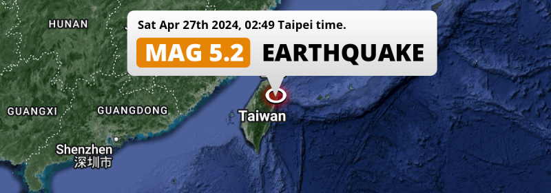
In the night of Saturday April 27th, 2024, a significant MAG-5.2 aftershock hit in the Philippine Sea 28 kilometer from Hualien City, Taiwan. The earthquake struck near a very densely populated region. Around 24 million people have been exposed to shaking. Other nearby countries are Japan and China.
Felt the earthquake? Share this article: 


Earthquake Summary
This earthquake hit under water in the Philippine Sea, right off the coast of Taiwan (1 mi offshore), 28 kilometer north-northeast of Hualien City in Hualien County. The center of this earthquake had a quite shallow depth of 39 km. Shallow earthquakes usually have a larger impact than earthquakes deep in the earth.
| Date and Time: | Apr 27, 2024 02:49 (Taipei Time) - Apr 26, 2024 18:49 Universal Time. |
|---|---|
| Location: | 28 km NNE of Hualien City, Hualien County, Taiwan. Coordinates 24°12'45"N 121°41'44"E. |
| Map: | 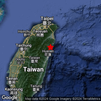 Map of area around epicenter. Click to open in Google Maps. |
| Magnitude: | MAG 5.2 Detected by 24 stations. Maximum Error Range ±0.063 . |
| Depth: | 39 km (24 mi) A quite shallow depth. |
| Max. Intensity: | V
Moderate On the Modified Mercalli Scale. |
| Tsunami Risk: | Low tsunami risk Earthquakes under MAG-6.5 do not usually cause tsunami's. Always stay cautious - More info here. |
Minimal impact predicted
Based on scientific estimates by the US Geographic Survey (USGS), the risk of high fatalities for this earthquake is classified at level GREEN (low). They expect an 65% likelyhood of between 0 and 1 fatalities, and a 96% chance that the number of fatalities falls no higher than 10.
The USGS classifies the economic impact of this earthquake at level GREEN (low). They expect an 65% likelyhood of between 0 and 1 million US Dollars in economic damage and impact, and a 96% chance that the economic impact of this earthquake falls no higher than 10 million USD.
Roughly 24 million people exposed to shaking
This earthquake may have been felt by around 24 million people. That is the expected population size of the area exposed to a level of shaking of II or higher on the Modified Mercalli scale according to the USGS.
The highest earthquake impact level for this earthquake is IV, which corresponds with light shaking and likely no damage. Roughly 2,315,000 people are expected to be exposed to this level. Intensity level III was experienced by the majority of people (around 21 million). In their region, weak shaking and probably no damage can be expected.
People in 3 countries have been exposed to shaking. In Taiwan , around 23 million people, with impact levels up to IV (light shaking, likely no damage). In China and Japan, a smaller number of people were exposed.
| People | MMI Level | Shaking | Damage |
|---|---|---|---|
| 0 | I |
Not noticable | None |
| 139,500 | II |
Very weak | None |
| 21,270,000 | III |
Weak | Probably none |
| 2,315,000 | IV |
Light | Likely none |
| 0 | V |
Moderate | Very light |
| 0 | VI |
Strong | Light |
| 0 | VII |
Very Strong | Moderate |
| 0 | VIII |
Severe | Moderate to heavy |
| 0 | IX |
Violent | Heavy |
| 0 | X |
Extreme | Very heavy |
Nearby towns and cities
Taiwan , Japan and China are all located within 300km distance of the epicenter of the earthquake.
Hualien City in Hualien County, Taiwan is the nearest significant place from the epicenter. The earthquake occurred 28 kilometer (17 mi) north-northeast of Hualien City. Hualien City experienced an earthquake intensity (MMI Scale) of roughly IV. That level implies light shaking and likely no damage.
Multiple major population centers exist within 300km of the earthquake that struck today. Taipei is located 94 km to the north and experienced an intensity of IV (light shaking, likely no damage). Hualien City is located 28 km to the south-southwest and experienced an intensity of IV (light shaking, likely no damage). Taichung is located 103 km to the west and experienced an intensity of III (weak shaking, probably no damage).
A complete list of nearby places is included below. Estimated intensity data (MMI) sourced from a shake-map published by the US Geographic Survey is shown where available (cities without data probably experienced little impact).
Overview of nearby places
| Distance | Place | Intensity (MMI) |
|---|---|---|
| 28 km (17 mi) SSW from epicenter |
Hualien City Hualien County, Taiwan. |
IV
Light |
| 61 km (38 mi) N from epicenter |
Yilan Yilan County, Taiwan. |
IV
Light |
| 79 km (49 mi) WSW from epicenter |
Puli Nantou County, Taiwan. |
IV
Light |
| 85 km (53 mi) NNW from epicenter |
Daxi Taoyuan City , Taiwan. |
III
Weak |
| 92 km (57 mi) NNW from epicenter |
Banqiao New Taipei City, Taiwan. |
IV
Light |
| 94 km (58 mi) N from epicenter |
Taipei Taipei City, Taiwan. |
IV
Light |
| 96 km (60 mi) NNW from epicenter |
Taoyuan City Taoyuan City , Taiwan. |
III
Weak |
| 99 km (62 mi) NW from epicenter |
Hsinchu Hsinchu County, Taiwan. |
III
Weak |
| 102 km (63 mi) N from epicenter |
Keelung Keelung, Taiwan. |
III
Weak |
| 103 km (64 mi) W from epicenter |
Taichung Taichung City, Taiwan. |
III
Weak |
| 106 km (66 mi) WSW from epicenter |
Zhongxing New Village Nantou County, Taiwan. |
III
Weak |
| 109 km (68 mi) WSW from epicenter |
Lugu Nantou County, Taiwan. |
III
Weak |
| 110 km (68 mi) WSW from epicenter |
Nantou Nantou County, Taiwan. |
III
Weak |
| 117 km (73 mi) WSW from epicenter |
Yuanlin Changhua County, Taiwan. |
III
Weak |
| 130 km (81 mi) WSW from epicenter |
Douliu Yunlin County, Taiwan. |
III
Weak |
| 174 km (108 mi) SW from epicenter |
Yujing Tainan City, Taiwan. |
III
Weak |
| 203 km (126 mi) SW from epicenter |
Tainan Tainan City, Taiwan. |
III
Weak |
| 226 km (140 mi) WSW from epicenter |
Magong Penghu County , Taiwan. |
|
| 227 km (141 mi) SW from epicenter |
Kaohsiung Kaohsiung, Taiwan. |
III
Weak |
| 232 km (144 mi) SSW from epicenter |
Donggang Pingtung County, Taiwan. |
III
Weak |
| 250 km (155 mi) E from epicenter |
Ishigaki Okinawa, Japan. |
|
| 264 km (164 mi) SSW from epicenter |
Hengchun Pingtung County, Taiwan. |
|
| 288 km (179 mi) NW from epicenter |
Fuqing Fujian, China. |
|
| 289 km (180 mi) WNW from epicenter |
Jiangkou Fujian, China. |
|
| 292 km (181 mi) NW from epicenter |
Tantou Fujian, China. |
Earthquake Intensity Map
The graph below overlays a map of the region around the epicenter with earthquake intensity data provided by the US Geographic Survey. The highest intensity level detected for this earthquake is IV.

Shaking reported by 26 people
People that feel an earthquake may report their experience to the US Geographic Survey. Currently, 26 people have reported shaking in 15 places, all within Taiwan.We keep updating this article as more ground reports become available. You may report that you felt this earthquake here.
Places with most reports:
- Yungho, Taipei Hsien, Taiwan: 7 people.
- Sanchung, Taipei Hsien, Taiwan: 3 people.
- Hsinchuang, Taipei Hsien, Taiwan: 2 people.
- Shulin, Taipei Hsien, Taiwan: 2 people.
- Taoyuan, Taoyuan, Taiwan: 2 people.
- Kaohsiung, Kaohsiung Shih, Taiwan: 1 person.
- Miaoli, Miaoli, Taiwan: 1 person.
- Chushan, Nantou, Taiwan: 1 person.
- Taichung, Taichung Shih, Taiwan: 1 person.
- Hsichih, Taipei Hsien, Taiwan: 1 person.
This is likely an aftershock
This earthquake was an aftershock. A larger mag. 5.7 earthquake struck 6 km (4 mi) south-southwest in advance of this 5.2 earthquake around 28 mins earlier.
Overview of foreshocks and aftershocks
| Classification | Magnitude | When | Where |
|---|---|---|---|
| Foreshock | M 4.1 |
3 days earlier Apr 24, 2024 09:46 (Taipei Time) | 27 km (17 mi) SSE from Main Shock. |
| Foreshock | M 4.4 |
3 days earlier Apr 24, 2024 09:53 (Taipei Time) | 26 km (16 mi) SSE from Main Shock. |
| Foreshock | M 4.3 |
3 days earlier Apr 24, 2024 11:28 (Taipei Time) | 53 km (33 mi) S from Main Shock. |
| Foreshock | M 4.4 |
3 days earlier Apr 24, 2024 13:01 (Taipei Time) | 30 km (19 mi) ENE from Main Shock. |
| Foreshock | M 4.9 |
2 days earlier Apr 24, 2024 15:30 (Taipei Time) | 45 km (28 mi) S from Main Shock. |
| Foreshock | M 4.3 |
2 days earlier Apr 24, 2024 15:51 (Taipei Time) | 40 km (25 mi) SSW from Main Shock. |
| Foreshock | M 4.0 |
2 days earlier Apr 24, 2024 16:31 (Taipei Time) | 23 km (14 mi) ENE from Main Shock. |
| Foreshock | M 4.3 |
2 days earlier Apr 24, 2024 17:23 (Taipei Time) | 28 km (17 mi) SSW from Main Shock. |
| Foreshock | M 4.0 |
2 days earlier Apr 24, 2024 21:37 (Taipei Time) | 43 km (26 mi) SSW from Main Shock. |
| Foreshock | M 4.6 |
2 days earlier Apr 25, 2024 00:59 (Taipei Time) | 73 km (45 mi) ESE from Main Shock. |
| Foreshock | M 5.1 |
2 days earlier Apr 25, 2024 02:11 (Taipei Time) | 70 km (44 mi) ESE from Main Shock. |
| Foreshock | M 4.3 |
2 days earlier Apr 25, 2024 03:19 (Taipei Time) | 67 km (41 mi) E from Main Shock. |
| Foreshock | M 4.0 |
2 days earlier Apr 25, 2024 07:53 (Taipei Time) | 30 km (19 mi) S from Main Shock. |
| Foreshock | M 4.0 |
2 days earlier Apr 25, 2024 08:11 (Taipei Time) | 52 km (32 mi) S from Main Shock. |
| Foreshock | M 4.7 |
2 days earlier Apr 25, 2024 08:19 (Taipei Time) | 55 km (34 mi) S from Main Shock. |
| Foreshock | M 4.7 |
2 days earlier Apr 25, 2024 09:23 (Taipei Time) | 39 km (24 mi) S from Main Shock. |
| Foreshock | M 4.0 |
2 days earlier Apr 25, 2024 09:43 (Taipei Time) | 53 km (33 mi) S from Main Shock. |
| Foreshock | M 4.2 |
1 day earlier Apr 25, 2024 22:17 (Taipei Time) | 7 km (4 mi) NE from Main Shock. |
| Foreshock | M 4.2 |
1 day earlier Apr 26, 2024 00:20 (Taipei Time) | 4 km (2.4 mi) WNW from Main Shock. |
| Foreshock | M 4.0 |
14 hrs earlier Apr 26, 2024 12:43 (Taipei Time) | 29 km (18 mi) S from Main Shock. |
| Foreshock | M 4.8 |
6 hrs earlier Apr 26, 2024 20:28 (Taipei Time) | 44 km (27 mi) S from Main Shock. |
| Main Shock | M 5.7 |
Apr 27, 2024 02:21 (Taipei Time) | - |
| Aftershock | M 4.3 |
24 mins later Apr 27, 2024 02:45 (Taipei Time) | 1.1 km (0.7 mi) NW from Main Shock. |
| Aftershock This Earthquake |
M 5.2 |
28 mins later Apr 27, 2024 02:49 (Taipei Time) | 6 km (4 mi) NNE from Main Shock. |
| Aftershock | M 4.4 |
52 mins later Apr 27, 2024 03:13 (Taipei Time) | 0.8 km (0.5 mi) SW from Main Shock. |
| Aftershock | M 4.5 |
2 hrs later Apr 27, 2024 04:08 (Taipei Time) | 37 km (23 mi) ESE from Main Shock. |
| Aftershock | M 4.3 |
7 hrs later Apr 27, 2024 09:06 (Taipei Time) | 2.4 km (1.5 mi) E from Main Shock. |
| Aftershock | M 4.0 |
1 day later Apr 28, 2024 03:24 (Taipei Time) | 27 km (17 mi) S from Main Shock. |
| Aftershock | M 4.4 |
1 day later Apr 28, 2024 04:30 (Taipei Time) | 37 km (23 mi) SSW from Main Shock. |
| Aftershock | M 4.1 |
2 days later Apr 28, 2024 16:13 (Taipei Time) | 8 km (5 mi) N from Main Shock. |
| Aftershock | M 4.2 |
2 days later Apr 28, 2024 20:05 (Taipei Time) | 39 km (24 mi) S from Main Shock. |
| Aftershock | M 4.4 |
2 days later Apr 29, 2024 01:40 (Taipei Time) | 6 km (4 mi) SSE from Main Shock. |
| Aftershock | M 4.2 |
3 days later Apr 30, 2024 00:21 (Taipei Time) | 11 km (7 mi) S from Main Shock. |
More earthquakes coming?
Aftershocks are usually at least 1 order of magnitude less strong than main shocks. The more time passes, the smaller the chance and likely strength of any potential aftershocks.
It's always adviced to be cautious of the risk of a larger shock following any significant earthquake, however this risk is fairly small. There is a roughly 94 percent change that no larger main shock will follow in the days following this earthquake.
Read: How to Stay Safe during an Earthquake (cdc.gov).Earthquakes like this happen often in the region
Earthquakes of this strength are very common in the region. In total, 100 earthquakes with a magnitude of 5.2 or higher have been registered within 300km (186 mi) of this epicenter in the past 10 years. This comes down to an average of once every month.
Low tsunami risk
Based on early data it appears this earthquake was not strong enough (lower than MAG-6.5) to be likely to cause destructive tsunami's. However this earthquake appeared to have hit at a shallow depth under sea, so stay cautious and monitor advice from local authorities.
Tsunami Risk Factors
| Factor | Under Sea? | MAG-6.5 or stronger? | Shallow depth? |
|---|---|---|---|
| Explanation | Almost all tsunami's are caused by earthquakes with their epicenter under sea or very near the sea. However stay cautious in coastal areas as earthquakes on land may cause landslides into sea, potentially still causing a local tsunami. | Under MAG 6.5: Very unlikely to cause a tsunami. MAG 6.5 to 7.5: Destructive tsunami's do occur, but are uncommon. Likely to observe small sea level changes. MAG 7.6+: Earthquakes with these magnitudes might produce destructive tsunami's. |
Most destructive tsunami's are caused by shallow earthquakes with a depth between 0 and 100km under the surface of the earth. Deeper tsunami's are unlikely to displace to ocean floor. |
| This Earthquake | This earthquake appears to have struck under the sea. | Not this earthquake. This earthquake had a magnitude of 5.2. Earthquakes of this strength are unlikely to trigger a tsunami. |
This earthquake occurred at a depth of of 39 km (24 mi). Earthquakes this shallow could trigger a tsunami. |
Sources
Last updated 06/05/24 19:08 (). This article contains currently available information about the earthquake and is automatically composed. We continue to update this article up to a few days after the earthquake occurred.
- US Geographic Society (USGS): Earthquake us6000mu45
- European-Mediterranean Seismological Centre (EMSC): Earthquake 20240426_0000226
- Geonames.org: World Cities Database
- Google Maps: Static API
- Earthquakelist.org: Historic Earthquakes Database
Share this article:
