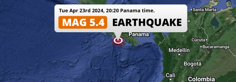
A shallow and significant Magnitude 5.4 earthquake struck in the North Pacific Ocean 100 kilometer from David, Panama in the evening of Tuesday April 23rd, 2024. Around 1.4 million people have been exposed to shaking. Another nearby country is Costa Rica.
Felt the earthquake? Share this article: 


Earthquake Summary
This earthquake hit under water in the North Pacific Ocean, 55 kilometers (34 mi) off the coast of Panama, 100 kilometer south of David in Chiriquí. The center of this earthquake had a very shallow depth of 10 km. Shallow earthquakes usually have a larger impact than earthquakes deep in the earth.
| Date and Time: | Apr 23, 2024 08:20PM (Panama Time) - Apr 24, 2024 01:20 Universal Time. |
|---|---|
| Location: | 100 km south of David, Chiriquí, Panama. Coordinates 7°31'40"N 82°22'29"W. |
| Map: | 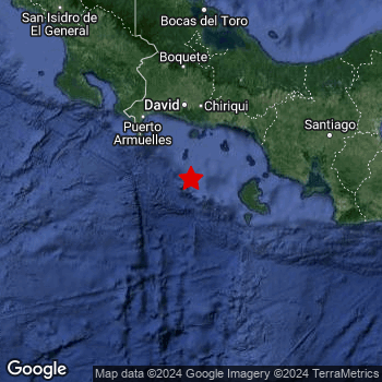 Map of area around epicenter. Click to open in Google Maps. |
| Magnitude: | MAG 5.4 Detected by 70 stations. Maximum Error Range ±0.037 . |
| Depth: | 10 km (6 mi) A very shallow depth. |
| Max. Intensity: | V
Moderate On the Modified Mercalli Scale. |
| Tsunami Risk: | Low tsunami risk Earthquakes under MAG-6.5 do not usually cause tsunami's. Always stay cautious - More info here. |
Minimal impact predicted
Based on scientific estimates by the US Geographic Survey (USGS), the risk of high fatalities for this earthquake is classified at level GREEN (low). They expect an 65% likelyhood of between 0 and 1 fatalities, and a 96% chance that the number of fatalities falls no higher than 10.
The USGS classifies the economic impact of this earthquake at level GREEN (low). They expect an 65% likelyhood of between 0 and 1 million US Dollars in economic damage and impact, and a 96% chance that the economic impact of this earthquake falls no higher than 10 million USD.
Roughly 1.4 million people exposed to shaking
An estimated 1.4 million have been exposed to shaking (An MMI or Modified Mercalli Intensity level II or higher) as a result of this earthquake according scientific estimates published by the USGS.
The highest earthquake impact level for this earthquake is IV, which corresponds with light shaking and likely no damage. Roughly 155,300 people are expected to be exposed to this level. Intensity level III was experienced by the majority of people (around 1.2 million). In their region, weak shaking and probably no damage can be expected.
People in 2 countries have been exposed to shaking. In Panama , around 1.1 million people, with impact levels up to IV (light shaking, likely no damage). In Costa Rica , around 290 thousand people.
| People | MMI Level | Shaking | Damage |
|---|---|---|---|
| 0 | I |
Not noticable | None |
| 87,090 | II |
Very weak | None |
| 1,160,000 | III |
Weak | Probably none |
| 155,300 | IV |
Light | Likely none |
| 0 | V |
Moderate | Very light |
| 0 | VI |
Strong | Light |
| 0 | VII |
Very Strong | Moderate |
| 0 | VIII |
Severe | Moderate to heavy |
| 0 | IX |
Violent | Heavy |
| 0 | X |
Extreme | Very heavy |
Nearby towns and cities
This earthquake struck within proximity of multiple countries. Panama and Costa Rica are both within 300km distance of its epicenter.
Located 95 kilometer (59 mi) south of the epicenter of this earthquake, Pedregal (Chiriquí, Panama) is the nearest significant population center. The intensity of shaking and damage in Pedregal is estimated to be around level IV on the Modified Mercalli Intensity scale (light shaking, likely no damage).
The table below provides an overview of all places in proximity of today's earthquake. Where available, the estimated intensity on the Modified Mercalli Intensity Scale in each place is included. Places where this information is omitted likely experienced little impact.
Overview of nearby places
| Distance | Place | Intensity (MMI) |
|---|---|---|
| 95 km (59 mi) N from epicenter |
Pedregal Chiriquí, Panama. |
IV
Light |
| 100 km (62 mi) N from epicenter |
David Chiriquí, Panama. |
IV
Light |
| 113 km (70 mi) NNW from epicenter |
La Concepción Chiriquí, Panama. |
III
Weak |
| 166 km (103 mi) ENE from epicenter |
Santiago de Veraguas Veraguas, Panama. |
III
Weak |
| 212 km (132 mi) N from epicenter |
Changuinola Bocas del Toro, Panama. |
|
| 248 km (154 mi) ENE from epicenter |
Penonomé Coclé, Panama. |
|
| 251 km (156 mi) NW from epicenter |
San Isidro San José, Costa Rica. |
|
| 283 km (176 mi) NNW from epicenter |
Limón Limón, Costa Rica. |
Earthquake Intensity Map
The graph below overlays a map of the region around the epicenter with earthquake intensity data provided by the US Geographic Survey. The highest intensity level detected for this earthquake is IV.

Shaking reported by 3 people in 2 countries
People that feel an earthquake may report their experience to the US Geographic Survey. Currently, 3 people have reported shaking in 2 places in 2 countries (Dominican Republic, Panama).We keep updating this article as more ground reports become available. You may report that you felt this earthquake here.
Places with most reports:
- Boquete, Chiriquí, Panama: 2 people.
- Los Llanos, San Pedro de Macorís, Dominican Republic: 1 person.
12 Aftershocks detected
After this earthquake struck, 12 smaller aftershocks occurred. A 4.4 magnitude earthquake hit 17 hrs later 13 km (8 mi) south-southwest of this earthquake.
This main shock was prefaced by 4 smaller foreshocks. Nearby this earthquake a foreshock struck 3 days earlier. It measured a magnitude of 3.1
Overview of foreshocks and aftershocks
| Classification | Magnitude | When | Where |
|---|---|---|---|
| Foreshock | M 2.7 |
3 days earlier Apr 21, 2024 02:21AM (Panama Time) | 99 km (62 mi) NNW from Main Shock. |
| Foreshock | M 3.1 |
3 days earlier Apr 21, 2024 04:50AM (Panama Time) | 83 km (51 mi) NNW from Main Shock. |
| Foreshock | M 2.9 |
2 days earlier Apr 21, 2024 07:21PM (Panama Time) | 63 km (39 mi) NNW from Main Shock. |
| Foreshock | M 3.0 |
14 hrs earlier Apr 23, 2024 06:26AM (Panama Time) | 96 km (60 mi) NNW from Main Shock. |
| Main Shock This Earthquake |
M 5.4 |
Apr 23, 2024 08:20PM (Panama Time) | - |
| Aftershock | M 4.4 |
15 mins later Apr 23, 2024 08:35PM (Panama Time) | 16 km (10 mi) SSW from Main Shock. |
| Aftershock | M 4.0 |
15 mins later Apr 23, 2024 08:35PM (Panama Time) | 43 km (27 mi) NW from Main Shock. |
| Aftershock | M 3.7 |
34 mins later Apr 23, 2024 08:54PM (Panama Time) | 21 km (13 mi) SSW from Main Shock. |
| Aftershock | M 3.1 |
41 mins later Apr 23, 2024 09:01PM (Panama Time) | 49 km (30 mi) NW from Main Shock. |
| Aftershock | M 4.4 |
50 mins later Apr 23, 2024 09:10PM (Panama Time) | 20 km (12 mi) SSW from Main Shock. |
| Aftershock | M 4.0 |
50 mins later Apr 23, 2024 09:10PM (Panama Time) | 33 km (20 mi) NW from Main Shock. |
| Aftershock | M 3.8 |
4 hrs later Apr 24, 2024 12:40AM (Panama Time) | 14 km (9 mi) SSW from Main Shock. |
| Aftershock | M 4.4 |
17 hrs later Apr 24, 2024 01:34PM (Panama Time) | 13 km (8 mi) SSW from Main Shock. |
| Aftershock | M 3.4 |
2 days later Apr 26, 2024 05:31AM (Panama Time) | 97 km (60 mi) NNW from Main Shock. |
| Aftershock | M 3.5 |
2 days later Apr 26, 2024 07:49AM (Panama Time) | 12 km (7 mi) S from Main Shock. |
| Aftershock | M 3.3 |
3 days later Apr 26, 2024 10:52AM (Panama Time) | 34 km (21 mi) SE from Main Shock. |
| Aftershock | M 3.1 |
3 days later Apr 26, 2024 07:11PM (Panama Time) | 67 km (42 mi) NNW from Main Shock. |
More earthquakes coming?
The risk of aftershocks decreases rapidly over time. Usually, aftershocks are at least one order of magnitude lower than a main shock.
The chance that a significant earthquake like this one is followed by an even larger earthquake is not so large. On average, scientists estimate a 94% chance that a major earthquake will not be followed by an even larger one. It is still adviced to be aware of this risk
Read: How to Stay Safe during an Earthquake (cdc.gov).Earthquakes like this happen often in the region
Earthquakes of this strength are very common in the region. This is the strongest earthquake to hit since August 3rd, 2023, when a 5.9 magnitude earthquake hit 212 km (131 mi) further south. An even stronger magnitude 6.7 earthquake struck on October 20th, 2022.
In total, 30 earthquakes with a magnitude of 5.4 or higher have been registered within 300km (186 mi) of this epicenter in the past 10 years. This comes down to an average of once every 4 months.
Low tsunami risk
Based on early data it appears this earthquake was not strong enough (lower than MAG-6.5) to be likely to cause destructive tsunami's. However this earthquake appeared to have hit at a shallow depth under sea, so stay cautious and monitor advice from local authorities.
Tsunami Risk Factors
| Factor | Under Sea? | MAG-6.5 or stronger? | Shallow depth? |
|---|---|---|---|
| Explanation | Almost all tsunami's are caused by earthquakes with their epicenter under sea or very near the sea. However stay cautious in coastal areas as earthquakes on land may cause landslides into sea, potentially still causing a local tsunami. | Under MAG 6.5: Very unlikely to cause a tsunami. MAG 6.5 to 7.5: Destructive tsunami's do occur, but are uncommon. Likely to observe small sea level changes. MAG 7.6+: Earthquakes with these magnitudes might produce destructive tsunami's. |
Most destructive tsunami's are caused by shallow earthquakes with a depth between 0 and 100km under the surface of the earth. Deeper tsunami's are unlikely to displace to ocean floor. |
| This Earthquake | This earthquake appears to have struck under the sea. | Not this earthquake. This earthquake had a magnitude of 5.4. Earthquakes of this strength are unlikely to trigger a tsunami. |
This earthquake occurred at a depth of of 10 km (6 mi). Earthquakes this shallow could trigger a tsunami. |
Sources
Last updated 04/05/24 00:28 (). As more information on this earthquake becomes available this article will be updated. This article is automatically composed based on data originating from multiple sources.
- US Geographic Society (USGS): Earthquake us6000mtc6
- European-Mediterranean Seismological Centre (EMSC): Earthquake 20240424_0000008
- Geonames.org: World Cities Database
- Google Maps: Static API
- Earthquakelist.org: Historic Earthquakes Database
Share this article:
