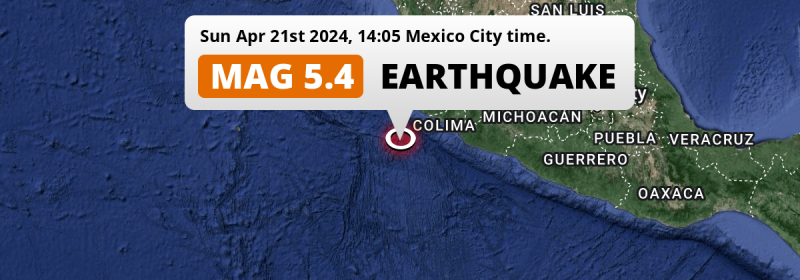
In the afternoon of Sunday April 21st, 2024, a shallow and significant M5.4 earthquake hit in the North Pacific Ocean 167 kilometer from Manzanillo, Mexico. Shaking may have been felt by a total of 1.1 million people.
Felt the earthquake? Share this article: 


Earthquake Summary
This earthquake hit under water in the North Pacific Ocean, 142 kilometers (88 mi) off the coast of Mexico, 167 kilometer southwest of Manzanillo in Colima. The center of this earthquake had a very shallow depth of 10 km. Shallow earthquakes usually have a larger impact than earthquakes deep in the earth.
| Date and Time: | Apr 21, 2024 14:05 (Mexico City Time) - Apr 21, 2024 19:05 Universal Time. |
|---|---|
| Location: | 167 km SW of Manzanillo, Colima, Mexico. Coordinates 18°13'60"N 105°37'40"W. |
| Map: | 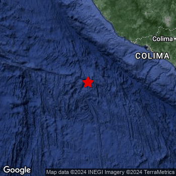 Map of area around epicenter. Click to open in Google Maps. |
| Magnitude: | MAG 5.4 Detected by 40 stations. Maximum Error Range ±0.049 . |
| Depth: | 10 km (6 mi) A very shallow depth. |
| Max. Intensity: | IV
Light On the Modified Mercalli Scale. |
| Tsunami Risk: | Low tsunami risk Earthquakes under MAG-6.5 do not usually cause tsunami's. Always stay cautious - More info here. |
Minimal impact predicted
Based on scientific estimates by the US Geographic Survey (USGS), the risk of high fatalities for this earthquake is classified at level GREEN (low). They expect an 65% likelyhood of between 0 and 1 fatalities, and a 96% chance that the number of fatalities falls no higher than 10.
The USGS classifies the economic impact of this earthquake at level GREEN (low). They expect an 65% likelyhood of between 0 and 1 million US Dollars in economic damage and impact, and a 96% chance that the economic impact of this earthquake falls no higher than 10 million USD.
Roughly 1.1 million people exposed to shaking
This earthquake may have been felt by around 1.1 million people. That is the expected population size of the area exposed to a level of shaking of II or higher on the Modified Mercalli scale according to the USGS.
An estimated 949,400 people were exposed to level III. At this level, weak shaking and probably no damage can be expected. All exposure to shaking was within the borders of Mexico .
| People | MMI Level | Shaking | Damage |
|---|---|---|---|
| 0 | I |
Not noticable | None |
| 146,300 | II |
Very weak | None |
| 949,400 | III |
Weak | Probably none |
| 0 | IV |
Light | Likely none |
| 0 | V |
Moderate | Very light |
| 0 | VI |
Strong | Light |
| 0 | VII |
Very Strong | Moderate |
| 0 | VIII |
Severe | Moderate to heavy |
| 0 | IX |
Violent | Heavy |
| 0 | X |
Extreme | Very heavy |
Nearby towns and cities
This earthquake may have been felt in Mexico . Located 158 kilometer (98 mi) southwest of the epicenter of this earthquake, Cihuatlán (Jalisco, Mexico) is the nearest significant population center. The intensity of shaking and damage in Cihuatlán is estimated to be around level III on the Modified Mercalli Intensity scale (weak shaking, probably no damage).
Multiple major population centers exist within 300km of the earthquake that struck today. Manzanillo is located 167 km to the north-east and experienced an intensity of III (weak shaking, probably no damage). Puerto Vallarta is located 268 km to the north (intensity unknown, possibly low). Colima is located 230 km to the east-northeast and experienced an intensity of III (weak shaking, probably no damage).
A complete list of nearby places is included below. Estimated intensity data (MMI) sourced from a shake-map published by the US Geographic Survey is shown where available (cities without data probably experienced little impact).
Overview of nearby places
| Distance | Place | Intensity (MMI) |
|---|---|---|
| 158 km (98 mi) NE from epicenter |
Cihuatlán Jalisco, Mexico. |
III
Weak |
| 167 km (104 mi) NE from epicenter |
Manzanillo Colima, Mexico. |
III
Weak |
| 192 km (119 mi) ENE from epicenter |
Ciudad de Armería Colima, Mexico. |
III
Weak |
| 199 km (124 mi) ENE from epicenter |
Tecomán Colima, Mexico. |
III
Weak |
| 216 km (134 mi) NE from epicenter |
Autlán de Navarro Jalisco, Mexico. |
III
Weak |
| 229 km (142 mi) NE from epicenter |
El Grullo Jalisco, Mexico. |
II
Weak |
| 230 km (143 mi) ENE from epicenter |
Ciudad de Villa de Álvarez Colima, Mexico. |
III
Weak |
| 230 km (143 mi) ENE from epicenter |
Colima Colima, Mexico. |
III
Weak |
| 262 km (163 mi) NNE from epicenter |
El Salto Jalisco, Mexico. |
|
| 268 km (167 mi) N from epicenter |
Puerto Vallarta Jalisco, Mexico. |
|
| 279 km (173 mi) ENE from epicenter |
Tuxpan Jalisco, Mexico. |
|
| 279 km (173 mi) NE from epicenter |
Zapotiltic Jalisco, Mexico. |
|
| 280 km (174 mi) NE from epicenter |
Ciudad Guzmán Jalisco, Mexico. |
|
| 280 km (174 mi) N from epicenter |
Ixtapa Jalisco, Mexico. |
|
| 280 km (174 mi) N from epicenter |
Mezcales Nayarit, Mexico. |
|
| 281 km (175 mi) NE from epicenter |
Sayula Jalisco, Mexico. |
|
| 284 km (176 mi) N from epicenter |
San José del Valle Jalisco, Mexico. |
|
| 297 km (185 mi) ENE from epicenter |
Tamazula de Gordiano Jalisco, Mexico. |
Earthquake Intensity Map
The graph below overlays a map of the region around the epicenter with earthquake intensity data provided by the US Geographic Survey. The highest intensity level detected for this earthquake is III.

Shaking reported by 1 person
People that feel an earthquake may report their experience to the US Geographic Survey. Currently, 1 person has reported shaking in one place in Mexico.We keep updating this article as more ground reports become available. You may report that you felt this earthquake here.
Places with most reports:
- Coatepec (San Bartolomé Coatepec), México, Mexico: 1 person.
8 Aftershocks detected
After this earthquake struck, 8 smaller aftershocks occurred. At a distance of 25 km (15 mi) west of this earthquake, an aftershock struck 11 hrs later. It measured a magnitude of 4.1
Before this earthquake struck, 4 smaller foreshocks occurred. Roughly 2 hrs before this earthquake, a foreshock measuring MAG-4.6 was detected nearby this earthquake.
Overview of foreshocks and aftershocks
| Classification | Magnitude | When | Where |
|---|---|---|---|
| Foreshock | M 4.5 |
3 hrs earlier Apr 21, 2024 11:33 (Mexico City Time) | 35 km (22 mi) SW from Main Shock. |
| Foreshock | M 4.6 |
2 hrs earlier Apr 21, 2024 11:41 (Mexico City Time) | 22 km (13 mi) SW from Main Shock. |
| Foreshock | M 3.7 |
1 hr earlier Apr 21, 2024 12:43 (Mexico City Time) | 15 km (9 mi) W from Main Shock. |
| Foreshock | M 3.8 |
32 mins earlier Apr 21, 2024 13:33 (Mexico City Time) | 12 km (8 mi) NW from Main Shock. |
| Main Shock This Earthquake |
M 5.4 |
Apr 21, 2024 14:05 (Mexico City Time) | - |
| Aftershock | M 4.1 |
21 mins later Apr 21, 2024 14:26 (Mexico City Time) | 19 km (12 mi) WNW from Main Shock. |
| Aftershock | M 3.8 |
1 hr later Apr 21, 2024 15:08 (Mexico City Time) | 21 km (13 mi) WNW from Main Shock. |
| Aftershock | M 4.0 |
10 hrs later Apr 22, 2024 00:31 (Mexico City Time) | 33 km (21 mi) W from Main Shock. |
| Aftershock | M 4.1 |
11 hrs later Apr 22, 2024 01:01 (Mexico City Time) | 25 km (15 mi) W from Main Shock. |
| Aftershock | M 3.7 |
11 hrs later Apr 22, 2024 01:20 (Mexico City Time) | 46 km (28 mi) W from Main Shock. |
| Aftershock | M 3.7 |
1 day later Apr 22, 2024 15:07 (Mexico City Time) | 24 km (15 mi) W from Main Shock. |
| Aftershock | M 3.9 |
1 day later Apr 22, 2024 15:46 (Mexico City Time) | 27 km (17 mi) NW from Main Shock. |
| Aftershock | M 3.7 |
1 day later Apr 22, 2024 15:51 (Mexico City Time) | 23 km (14 mi) NNW from Main Shock. |
More earthquakes coming?
Aftershocks are usually at least 1 order of magnitude less strong than main shocks. The more time passes, the smaller the chance and likely strength of any potential aftershocks.
The chance that a significant earthquake like this one is followed by an even larger earthquake is not so large. On average, scientists estimate a 94% chance that a major earthquake will not be followed by an even larger one. It is still adviced to be aware of this risk
Read: How to Stay Safe during an Earthquake (cdc.gov).Earthquakes like this happen often in the region
Earthquakes of this strength are very common in the region. This is the strongest earthquake to hit since September 8th, 2023, when a 5.8 magnitude earthquake hit 150 km (93 mi) further north-northeast. An even stronger magnitude 7.6 earthquake struck on September 19th, 2022.
In total, 27 earthquakes with a magnitude of 5.4 or higher have been registered within 300km (186 mi) of this epicenter in the past 10 years. This comes down to an average of once every 5 months.
Low tsunami risk
Based on early data it appears this earthquake was not strong enough (lower than MAG-6.5) to be likely to cause destructive tsunami's. However this earthquake appeared to have hit at a shallow depth under sea, so stay cautious and monitor advice from local authorities.
Tsunami Risk Factors
| Factor | Under Sea? | MAG-6.5 or stronger? | Shallow depth? |
|---|---|---|---|
| Explanation | Almost all tsunami's are caused by earthquakes with their epicenter under sea or very near the sea. However stay cautious in coastal areas as earthquakes on land may cause landslides into sea, potentially still causing a local tsunami. | Under MAG 6.5: Very unlikely to cause a tsunami. MAG 6.5 to 7.5: Destructive tsunami's do occur, but are uncommon. Likely to observe small sea level changes. MAG 7.6+: Earthquakes with these magnitudes might produce destructive tsunami's. |
Most destructive tsunami's are caused by shallow earthquakes with a depth between 0 and 100km under the surface of the earth. Deeper tsunami's are unlikely to displace to ocean floor. |
| This Earthquake | This earthquake appears to have struck under the sea. | Not this earthquake. This earthquake had a magnitude of 5.4. Earthquakes of this strength are unlikely to trigger a tsunami. |
This earthquake occurred at a depth of of 10 km (6 mi). Earthquakes this shallow could trigger a tsunami. |
Sources
Last updated 03/05/24 19:28 (). This article is automatically generated based on available data. We keep checking multiple sources for additional information. This article gets updated as new details on this earthquake become available.
- US Geographic Society (USGS): Earthquake us7000mdpx
- European-Mediterranean Seismological Centre (EMSC): Earthquake 20240421_0000211
- Geonames.org: World Cities Database
- Google Maps: Static API
- Earthquakelist.org: Historic Earthquakes Database
Share this article:
