Latest earthquakes near Türkiye today
Complete overview of the latest earthquakes near the country Türkiye, updated every minute. Did you feel an earthquake today in Türkiye? If an earthquake is happening right now near Türkiye (also known as Turkey), it will show up within minutes.
Recent Türkiye Earthquake News
These are the latest articles published related to earthquakes occurring near Türkiye. Check our Earthquake News section for a complete overview of articles written on earthquakes near Türkiye and elsewhere.
 Jun 7, 2026 01:02PM
Shallow M5.2 Earthquake struck on Sunday Afternoon near Athens in Greece.
Jun 7, 2026 01:02PM
Shallow M5.2 Earthquake struck on Sunday Afternoon near Athens in Greece.
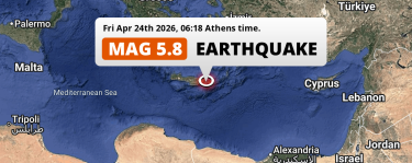 Apr 24, 2026 06:18AM
Shallow M5.7 Earthquake struck on Friday Morning near Irákleion in Greece.
Apr 24, 2026 06:18AM
Shallow M5.7 Earthquake struck on Friday Morning near Irákleion in Greece.
 Aug 10, 2025 07:53PM
On Sunday Evening a DAMAGING M6.1 Earthquake struck near Balıkesir in Türkiye.
Aug 10, 2025 07:53PM
On Sunday Evening a DAMAGING M6.1 Earthquake struck near Balıkesir in Türkiye.
Türkiye Earthquake Statistics
Average
A total of 3177 earthquakes with a magnitude of four or above have struck within 300 km (186 mi) of Türkiye in the past 10 years. This comes down to a yearly average of 317 earthquakes per year, or 26 per month. On average an earthquake will hit near Türkiye roughly every 1 days.
A relatively large number of earthquakes occurred near Türkiye in 2023. A total of 876 earthquakes (mag 4+) were detected within 300 km of Türkiye that year. The strongest had a 7.8 magnitude.

Magnitude Distribution
The table below visualizes the distribution of all earthquakes that occurred within 300km of Türkiye in the past 10 years. No earthquakes with a magnitude of 8 or above have occurred near Türkiye during this time. Usually, higher magnitudes are less common than lower magnitudes. Small earthquakes with a magnitude below 4 on the Richter scale have been omitted from this overview.
| Magnitude | Earthquakes | Percentage |
|---|---|---|
| Mag. 4 | 2980 | 93.8% |
| Mag. 5 | 180 | 5.67% |
| Mag. 6 | 14 | 0.44% |
| Mag. 7 | 3 | 0.09% |
| Mag. 8 | 0 | 0.0% |
| Mag. 9 | 0 | 0.0% |
| Mag. 10 | 0 | 0.0% |
Strongest earthquakes near Türkiye
The strongest recent earthquake of the past 10 years near Türkiye occurred on Feb 6, 2023 04:17 local time (Europe/Istanbul timezone). It had a magnitude of 7.8 and struck 38 kilometers (24 mi) west-northwest of Gaziantep, at a depth of 10 km. Discover more strong earthquakes near Türkiye in the list below.
In the table below you will find the strongest earthquakes that occurred near Türkiye in the past 10 years. You can use the tabs to find the heaviest historic earthquakes since the year 1900 or within a specific year or distance from Türkiye.
Earthquakes by region of Türkiye
Click the links below for earthquake reports for regions in Türkiye.
- Adana
- Adıyaman
- Afyonkarahisar
- Aksaray
- Amasya
- Ankara
- Antalya
- Ardahan (Արդահանի նահանգ)
- Artvin (Արդվինի նահանգ)
- Aydın (Επαρχία Αϊδινίου)
- Ağrı
- Balıkesir
- Bartın
- Batman
- Bayburt
- Bilecik
- Bingöl
- Bitlis (Բաղեշի նահանգ)
- Bolu
- Burdur
- Bursa
- Canakkale (Çanakkale)
- Denizli
- Diyarbakır
- Düzce
- Edirne
- Elazığ
- Erzincan
- Erzurum (Կարինի նահանգ)
- Eskişehir
- Gaziantep
- Giresun
- Gümüşhane
- Hakkâri
- Hatay
- Isparta
- Iğdır (Ցոլակերտի նահանգ)
- Kahramanmaraş
- Karabük
- Karaman
- Kars
- Kastamonu
- Kayseri
- Kilis
- Kocaeli
- Konya
- Kütahya
- Kırklareli
- Kırıkkale
- Kırşehir
- Malatya
- Manisa
- Mardin
- Mersin
- Muğla (Επαρχία Μούγλων)
- Muş (Մուշի նահանգ)
- Nevşehir
- Niğde
- Ordu
- Osmaniye
- Rize
- Sakarya
- Samsun
- Siirt
- Sinop
- Sivas
- Tekirdağ
- Tokat
- Trabzon
- Tunceli
- Uşak
- Van (Վանի նահանգ)
- Yalova
- Yozgat
- Zonguldak
- Çankırı
- Çorum
- İstanbul
- İzmir
- Şanlıurfa
- Şırnak
Frequently Asked Questions
These questions are commonly asked in relation to earthquakes occurring near Türkiye.
When was the last earthquake in Türkiye?
A 2 magnitude earthquake hit near Türkiye on the night of June 22, 2026 at 05:38 local time (Europe/Istanbul). The center of this earthquake was located 75km south-east of Denizli at a depth of 12km under land. Check the list on our website for any earthquakes occurring near Türkiye in the past hours.
What was the strongest earthquake near Türkiye?
A 7.8 magnitude earthquake hit near Türkiye on the night of February 6, 2023 at 04:17 local time (Europe/Istanbul). The center of this earthquake was located 38km west-northwest of Gaziantep at a depth of 10km under land. This is the strongest earthquake that occurred near Türkiye since the year 1900.
How often do earthquakes occur near Türkiye?
In the past 10 years, 3177 earthquakes with a magnitude of four or higher occurred within a 300 kilometer range from Türkiye. This averages to 318 earthquakes yearly, or one earthquake every 1 days.
