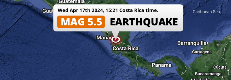
In the afternoon of Wednesday April 17th, 2024, a significant MAG-5.5 earthquake hit under land 150 kilometer from Managua in Nicaragua. Around 9 million people have been exposed to shaking. Another country near the epicenter is Costa Rica.
Felt the earthquake? Share this article: 


Earthquake Summary
The earthquake struck on land in Nicaragua, 150 kilometer (93 mi) south-east of Managua. The center of this earthquake had an intermediate depth of 154 km.
| Date and Time: | Apr 17, 2024 03:21PM (Costa Rica Time) - Apr 17, 2024 21:21 Universal Time. |
|---|---|
| Location: | 29 km NW of San José, Alajuela, Costa Rica. Coordinates 11°8'50"N 85°18'50"W. |
| Map: | 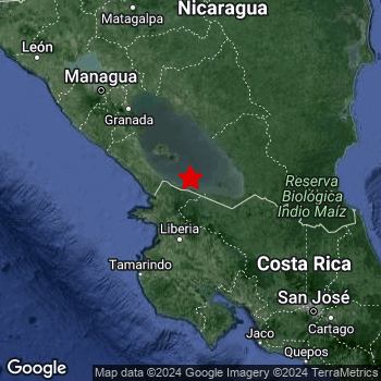 Map of area around epicenter. Click to open in Google Maps. |
| Magnitude: | MAG 5.5 Detected by 87 stations. Maximum Error Range ±0.033 . |
| Depth: | 154 km (96 mi) An intermediate depth. |
| Max. Intensity: | IV
Light On the Modified Mercalli Scale. |
| Tsunami Risk: | Tsunami very unlikely Tsunami's are usually caused by MAG-6.5+ earthquakes, less than 100km shallow, and with an epicenter under sea. Neither of this seems to be the case. Always stay cautious - More info here. |
Minimal impact predicted
Based on scientific estimates by the US Geographic Survey (USGS), the risk of high fatalities for this earthquake is classified at level GREEN (low). They expect an 65% likelyhood of between 0 and 1 fatalities, and a 96% chance that the number of fatalities falls no higher than 10.
The USGS classifies the economic impact of this earthquake at level GREEN (low). They expect an 65% likelyhood of between 0 and 1 million US Dollars in economic damage and impact, and a 96% chance that the economic impact of this earthquake falls no higher than 10 million USD.
Roughly 9 million people exposed to shaking
The USGS has published a report estimating the number of people exposed to this earthquake. Acoording to their analysis, roughly 9 million have been exposed to shaking at an MMI level of II or higher.
The highest earthquake impact level for this earthquake is IV, which corresponds with light shaking and likely no damage. Roughly 1,097,000 people are expected to be exposed to this level. Intensity level III was experienced by the majority of people (around 8 million). In their region, weak shaking and probably no damage can be expected.
People in 2 countries have been exposed to shaking. In Costa Rica , around 4.8 million people, with impact levels up to IV (light shaking, likely no damage). In Nicaragua , around 4.3 million people.
| People | MMI Level | Shaking | Damage |
|---|---|---|---|
| 0 | I |
Not noticable | None |
| 238,300 | II |
Very weak | None |
| 7,702,000 | III |
Weak | Probably none |
| 1,097,000 | IV |
Light | Likely none |
| 0 | V |
Moderate | Very light |
| 0 | VI |
Strong | Light |
| 0 | VII |
Very Strong | Moderate |
| 0 | VIII |
Severe | Moderate to heavy |
| 0 | IX |
Violent | Heavy |
| 0 | X |
Extreme | Very heavy |
Nearby towns and cities
2 countries can be found within 300km of the epicenter of this earthquake: Costa Rica and Nicaragua .
San José in Alajuela, Costa Rica is the nearest significant place from the epicenter. The earthquake occurred 29 kilometer (18 mi) northwest of San José. The intensity of shaking and damage in San José is estimated to be around level IV on the Modified Mercalli Intensity scale (light shaking, likely no damage).
Major cities near this earthquake: Managua is located 150 km to the northwest and experienced an intensity of III (weak shaking, probably no damage). San José is located 191 km to the south-east and experienced an intensity of III (weak shaking, probably no damage). Masaya is located 125 km to the northwest and experienced an intensity of III (weak shaking, probably no damage).
A complete list of nearby places is included below. Estimated intensity data (MMI) sourced from a shake-map published by the US Geographic Survey is shown where available (cities without data probably experienced little impact).
Overview of nearby places
| Distance | Place | Intensity (MMI) |
|---|---|---|
| 29 km (18 mi) SE from epicenter |
San José Alajuela, Costa Rica. |
IV
Light |
| 59 km (37 mi) SSW from epicenter |
Liberia Guanacaste, Costa Rica. |
IV
Light |
| 65 km (40 mi) WNW from epicenter |
Rivas Rivas, Nicaragua. |
IV
Light |
| 83 km (52 mi) SSE from epicenter |
Cañas Guanacaste, Costa Rica. |
IV
Light |
| 105 km (65 mi) NW from epicenter |
Nandaime Granada, Nicaragua. |
IV
Light |
| 107 km (66 mi) N from epicenter |
Juigalpa Chontales, Nicaragua. |
IV
Light |
| 111 km (69 mi) ENE from epicenter |
Nueva Guinea South Caribbean Coast, Nicaragua. |
IV
Light |
| 112 km (70 mi) S from epicenter |
Nicoya Guanacaste, Costa Rica. |
IV
Light |
| 112 km (70 mi) NW from epicenter |
Granada Granada, Nicaragua. |
III
Weak |
| 124 km (77 mi) NW from epicenter |
Masatepe Masaya, Nicaragua. |
III
Weak |
| 124 km (77 mi) NW from epicenter |
Jinotepe Carazo, Nicaragua. |
III
Weak |
| 125 km (78 mi) NW from epicenter |
Masaya Masaya, Nicaragua. |
III
Weak |
| 128 km (80 mi) NW from epicenter |
Diriamba Carazo, Nicaragua. |
III
Weak |
| 129 km (80 mi) NW from epicenter |
San Marcos Carazo, Nicaragua. |
III
Weak |
| 133 km (83 mi) SE from epicenter |
Quesada Alajuela, Costa Rica. |
III
Weak |
| 139 km (86 mi) N from epicenter |
Camoapa Boaco, Nicaragua. |
III
Weak |
| 140 km (87 mi) SSE from epicenter |
Puntarenas Puntarenas, Costa Rica. |
IV
Light |
| 142 km (88 mi) SSE from epicenter |
Chacarita Puntarenas, Costa Rica. |
III
Weak |
| 143 km (89 mi) NW from epicenter |
El Crucero Managua, Nicaragua. |
III
Weak |
| 145 km (90 mi) WNW from epicenter |
San Rafael del Sur Managua, Nicaragua. |
III
Weak |
| 145 km (90 mi) NW from epicenter |
Tipitapa Managua, Nicaragua. |
III
Weak |
| 147 km (91 mi) SSE from epicenter |
Esparza Puntarenas, Costa Rica. |
III
Weak |
| 150 km (93 mi) NW from epicenter |
Managua Managua, Nicaragua. |
III
Weak |
| 152 km (94 mi) NNW from epicenter |
Boaco Boaco, Nicaragua. |
III
Weak |
| 159 km (99 mi) NW from epicenter |
Ciudad Sandino Managua, Nicaragua. |
III
Weak |
| 164 km (102 mi) NE from epicenter |
Rama South Caribbean Coast, Nicaragua. |
III
Weak |
| 174 km (108 mi) SE from epicenter |
Alajuela Alajuela, Costa Rica. |
III
Weak |
| 181 km (112 mi) SE from epicenter |
Mercedes Norte Heredia, Costa Rica. |
III
Weak |
| 182 km (113 mi) SE from epicenter |
San Francisco Heredia, Costa Rica. |
III
Weak |
| 183 km (114 mi) SE from epicenter |
Heredia Heredia, Costa Rica. |
III
Weak |
| 184 km (114 mi) SE from epicenter |
San Rafael Abajo San José, Costa Rica. |
III
Weak |
| 184 km (114 mi) NW from epicenter |
Nagarote León, Nicaragua. |
III
Weak |
| 185 km (115 mi) SE from epicenter |
San Pablo Heredia, Costa Rica. |
III
Weak |
| 187 km (116 mi) SE from epicenter |
San Rafael San José, Costa Rica. |
III
Weak |
| 189 km (117 mi) SE from epicenter |
San Juan San José, Costa Rica. |
III
Weak |
| 191 km (119 mi) SE from epicenter |
Guadalupe San José, Costa Rica. |
III
Weak |
| 191 km (119 mi) SE from epicenter |
San Felipe San José, Costa Rica. |
III
Weak |
| 191 km (119 mi) SE from epicenter |
San Vicente San José, Costa Rica. |
III
Weak |
| 191 km (119 mi) SE from epicenter |
San Vicente de Moravia San José, Costa Rica. |
III
Weak |
| 191 km (119 mi) SE from epicenter |
San José San José, Costa Rica. |
III
Weak |
| 193 km (120 mi) SE from epicenter |
Purral San José, Costa Rica. |
III
Weak |
| 193 km (120 mi) SE from epicenter |
San Pedro San José, Costa Rica. |
III
Weak |
| 193 km (120 mi) SE from epicenter |
Ipís San José, Costa Rica. |
III
Weak |
| 194 km (121 mi) ENE from epicenter |
Bluefields South Caribbean Coast, Nicaragua. |
III
Weak |
| 196 km (122 mi) SE from epicenter |
Curridabat San José, Costa Rica. |
III
Weak |
| 196 km (122 mi) SE from epicenter |
Aserrí San José, Costa Rica. |
III
Weak |
| 197 km (122 mi) SE from epicenter |
San Miguel San José, Costa Rica. |
III
Weak |
| 197 km (122 mi) ESE from epicenter |
Guápiles Limón, Costa Rica. |
III
Weak |
| 199 km (124 mi) SE from epicenter |
San Diego Cartago, Costa Rica. |
III
Weak |
| 208 km (129 mi) NNW from epicenter |
Matagalpa Matagalpa, Nicaragua. |
III
Weak |
| 223 km (139 mi) NW from epicenter |
León León, Nicaragua. |
III
Weak |
| 229 km (142 mi) NNW from epicenter |
Jinotega Jinotega, Nicaragua. |
|
| 244 km (152 mi) NNW from epicenter |
Estelí Estelí, Nicaragua. |
|
| 257 km (160 mi) NW from epicenter |
Chinandega Chinandega, Nicaragua. |
|
| 293 km (182 mi) N from epicenter |
Siuna North Caribbean Coast, Nicaragua. |
|
| 294 km (183 mi) NNW from epicenter |
Somoto Madriz, Nicaragua. |
Earthquake Intensity Map
The maximum intensity (MMI Scale) caused by this earthquake is IV. The map below shows in which areas this earthquake was the most and least impactful. It is based on data from the US Geographic Survey.

Shaking reported by 80 people in 2 countries
People that feel an earthquake may report their experience to the US Geographic Survey. Currently, 80 people have reported shaking in 41 places in 2 countries (Nicaragua, Costa Rica).We keep updating this article as more ground reports become available. You may report that you felt this earthquake here.
Places with most reports:
- Sardinal, Guanacaste, Costa Rica: 7 people.
- Juntas, Guanacaste, Costa Rica: 5 people.
- Paquera, Puntarenas, Costa Rica: 5 people.
- Sámara, Guanacaste, Costa Rica: 5 people.
- San José, San José, Costa Rica: 5 people.
- Jacó, Puntarenas, Costa Rica: 4 people.
- Quepos, Puntarenas, Costa Rica: 4 people.
- Fortuna, Alajuela, Costa Rica: 3 people.
- Tigra, Alajuela, Costa Rica: 2 people.
- Hojancha, Guanacaste, Costa Rica: 2 people.
2 Aftershocks detected
Since this main shock, 2 smaller aftershocks were detected. A 3 magnitude earthquake hit 2 days later 90 km (56 mi) south-east of this earthquake.
Overview of foreshocks and aftershocks
| Classification | Magnitude | When | Where |
|---|---|---|---|
| Main Shock This Earthquake |
M 5.5 |
Apr 17, 2024 03:21PM (Costa Rica Time) | - |
| Aftershock | M 3.0 |
2 days later Apr 19, 2024 11:14AM (Costa Rica Time) | 90 km (56 mi) SE from Main Shock. |
| Aftershock | M 2.5 |
3 days later Apr 20, 2024 04:46AM (Costa Rica Time) | 97 km (60 mi) SW from Main Shock. |
More earthquakes coming?
Aftershocks are usually at least 1 order of magnitude less strong than main shocks. The more time passes, the smaller the chance and likely strength of any potential aftershocks.
In only six percent of cases, significant earthquakes are followed by a larger main shock, making the current earthquake a foreshock. While the chance of this happening is not so large, it is adviced to maintain cautiousness in the hours and days following a major earthquake.
Read: How to Stay Safe during an Earthquake (cdc.gov).Earthquakes like this happen often in the region
Earthquakes of this strength are very common in the region. This is the strongest earthquake to hit since March 17th, 2024, when a 5.6 magnitude earthquake hit 289 km (179 mi) further west-northwest. An even stronger magnitude 6.6 earthquake struck on April 21st, 2022.
In total, 21 earthquakes with a magnitude of 5.5 or higher have been registered within 300km (186 mi) of this epicenter in the past 10 years. This comes down to an average of once every 6 months.
Tsunami very unlikely
It is very unlikely that this eartquake will cause any tsunami's. The reported magnitude is lower than the MAG-6.5 strength required to cause any earthquakes. In addition, this earthquake was not very shallow and appears to have occurred under land. However always stay cautious and monitor advice from local authorities.
Tsunami Risk Factors
| Factor | Under Sea? | MAG-6.5 or stronger? | Shallow depth? |
|---|---|---|---|
| Explanation | Almost all tsunami's are caused by earthquakes with their epicenter under sea or very near the sea. However stay cautious in coastal areas as earthquakes on land may cause landslides into sea, potentially still causing a local tsunami. | Under MAG 6.5: Very unlikely to cause a tsunami. MAG 6.5 to 7.5: Destructive tsunami's do occur, but are uncommon. Likely to observe small sea level changes. MAG 7.6+: Earthquakes with these magnitudes might produce destructive tsunami's. |
Most destructive tsunami's are caused by shallow earthquakes with a depth between 0 and 100km under the surface of the earth. Deeper tsunami's are unlikely to displace to ocean floor. |
| This Earthquake | Not this earthquake. This earthquake appears to have struck on land far from any coast. |
Not this earthquake. This earthquake had a magnitude of 5.5. Earthquakes of this strength are unlikely to trigger a tsunami. |
Not this earthquake. This earthquake occurred at a depth of 154 km (96 mi). Earthquakes this deep in the earth are unlikely to trigger a tsunami. |
Sources
Last updated 03/05/24 23:08 (). As more information on this earthquake becomes available this article will be updated. This article is automatically composed based on data originating from multiple sources.
- US Geographic Society (USGS): Earthquake us7000mcrs
- European-Mediterranean Seismological Centre (EMSC): Earthquake 20240417_0000262
- Geonames.org: World Cities Database
- Google Maps: Static API
- Earthquakelist.org: Historic Earthquakes Database
Share this article:
