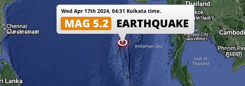
In the Andaman Or Burma Sea 40 kilometer from Port Blair, India, a significant MAG-5.2 earthquake occurred in the night of Wednesday April 17th, 2024.
Felt the earthquake? Share this article: 


Earthquake Summary
This earthquake hit under water in the Andaman Or Burma Sea, 31 kilometers (19 mi) off the coast of India, 40 kilometer south-east of Port Blair in Andaman and Nicobar. The center of this earthquake had a quite shallow depth of 54 km. Shallow earthquakes usually have a larger impact than earthquakes deep in the earth.
| Date and Time: | Apr 17, 2024 04:31 (Kolkata Time) - Apr 16, 2024 23:01 Universal Time. |
|---|---|
| Location: | 40 km SE of Port Blair, Andaman and Nicobar, India. Coordinates 11°23'16"N 92°58'57"E. |
| Map: | 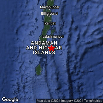 Map of area around epicenter. Click to open in Google Maps. |
| Magnitude: | MAG 5.2 Detected by 96 stations. Maximum Error Range ±0.059 . |
| Depth: | 54 km (34 mi) A quite shallow depth. |
| Tsunami Risk: | Low tsunami risk Earthquakes under MAG-6.5 do not usually cause tsunami's. Always stay cautious - More info here. |
Nearby towns and cities
This earthquake may have been felt in India . The closest significant population center near the earthquake is Port Blair in Andaman and Nicobar, India. Port Blair is located 40 kilometer (25 mi) south-east of the epicenter.
Overview of nearby places
| Distance | Place |
|---|---|
| 40 km (25 mi) NW from epicenter |
Port Blair Andaman and Nicobar, India. |
Shaking reported by 10 people
People that feel an earthquake may report their experience to the US Geographic Survey. Currently, 10 people have reported shaking in 2 places in India.We keep updating this article as more ground reports become available. You may report that you felt this earthquake here.
Places with most reports:
- Port Blair, Andaman and Nicobar Islands, India: 6 people.
- Bombūflat, Andaman and Nicobar Islands, India: 4 people.
Risk of aftershocks?
This earthquake did not have any significant foreshocks nor aftershocks occurring within 100km (62 mi) of its epicenter.
Earthquakes can create aftershocks. These are generally at least 1 magnitude lower than any main shock, and as time passes the chance and strength of aftershocks decreases.
The chance that a significant earthquake like this one is followed by an even larger earthquake is not so large. On average, scientists estimate a 94% chance that a major earthquake will not be followed by an even larger one. It is still adviced to be aware of this risk
Read: How to Stay Safe during an Earthquake (cdc.gov).Earthquakes like this happen often in the region
Earthquakes of this strength are very common in the region. This is the strongest earthquake to hit since August 2nd, 2023, when a 5.3 magnitude earthquake hit 250 km (155 mi) further south-southeast. An even stronger magnitude 6.1 earthquake struck on July 17th, 2020.
In total, 19 earthquakes with a magnitude of 5.2 or higher have been registered within 300km (186 mi) of this epicenter in the past 10 years. This comes down to an average of once every 6 months.
Low tsunami risk
Based on early data it appears this earthquake was not strong enough (lower than MAG-6.5) to be likely to cause destructive tsunami's. However this earthquake appeared to have hit at a shallow depth under sea, so stay cautious and monitor advice from local authorities.
Tsunami Risk Factors
| Factor | Under Sea? | MAG-6.5 or stronger? | Shallow depth? |
|---|---|---|---|
| Explanation | Almost all tsunami's are caused by earthquakes with their epicenter under sea or very near the sea. However stay cautious in coastal areas as earthquakes on land may cause landslides into sea, potentially still causing a local tsunami. | Under MAG 6.5: Very unlikely to cause a tsunami. MAG 6.5 to 7.5: Destructive tsunami's do occur, but are uncommon. Likely to observe small sea level changes. MAG 7.6+: Earthquakes with these magnitudes might produce destructive tsunami's. |
Most destructive tsunami's are caused by shallow earthquakes with a depth between 0 and 100km under the surface of the earth. Deeper tsunami's are unlikely to displace to ocean floor. |
| This Earthquake | This earthquake appears to have struck under the sea. | Not this earthquake. This earthquake had a magnitude of 5.2. Earthquakes of this strength are unlikely to trigger a tsunami. |
This earthquake occurred at a depth of of 54 km (34 mi). Earthquakes this shallow could trigger a tsunami. |
Sources
Last updated 04/05/24 01:08 (). As more information on this earthquake becomes available this article will be updated. This article is automatically composed based on data originating from multiple sources.
- US Geographic Society (USGS): Earthquake us7000mcjj
- European-Mediterranean Seismological Centre (EMSC): Earthquake 20240416_0000281
- Geonames.org: World Cities Database
- Google Maps: Static API
- Earthquakelist.org: Historic Earthquakes Database
Share this article:
