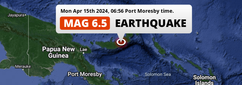
Under land 108 kilometer from Kimbe in Papua New Guinea, a strong MAG-6.5 earthquake occurred in the early morning of Monday April 15th, 2024. The USGS has indicated there is a potential risk at tsunami's following this earthquake.
Felt the earthquake? Share this article: 


Earthquake Summary
The earthquake struck on land in Papua New Guinea, 108 kilometer (67 mi) east-southeast of Kimbe in West New Britain. The center of this earthquake had a quite shallow depth of 49 km. Shallow earthquakes usually have a larger impact than earthquakes deep in the earth.
| Date and Time: | Apr 15, 2024 06:56 (Port Moresby Time) - Apr 14, 2024 20:56 Universal Time. |
|---|---|
| Location: | 108 km ESE of Kimbe, West New Britain, Papua New Guinea. Coordinates 5°48'13"S 151°4'60"E. |
| Map: | 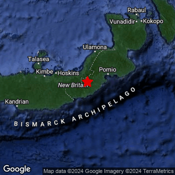 Map of area around epicenter. Click to open in Google Maps. |
| Magnitude: | MAG 6.5 |
| Depth: | 49 km (30 mi) A quite shallow depth. |
| Max. Intensity: | VII
Very Strong On the Modified Mercalli Scale. |
| Tsunami Risk: | Potential tsunami risk The USGS has indicated there is a potential risk at tsunami's following this earthquake. Always stay cautious - More info here. |
Potential tsunami risk
There is a potential tsunami risk in the aftermath of this earthquake, immediately evacuate to higher grounds away from coastal areas and monitor advice from local authorities. The US Geographic Survey organization has indicated a potential risk for tsunami's following this earthquake.
Tsunami Risk Factors
| Factor | Under Sea? | MAG-6.5 or stronger? | Shallow depth? |
|---|---|---|---|
| Explanation | Almost all tsunami's are caused by earthquakes with their epicenter under sea or very near the sea. However stay cautious in coastal areas as earthquakes on land may cause landslides into sea, potentially still causing a local tsunami. | Under MAG 6.5: Very unlikely to cause a tsunami. MAG 6.5 to 7.5: Destructive tsunami's do occur, but are uncommon. Likely to observe small sea level changes. MAG 7.6+: Earthquakes with these magnitudes might produce destructive tsunami's. |
Most destructive tsunami's are caused by shallow earthquakes with a depth between 0 and 100km under the surface of the earth. Deeper tsunami's are unlikely to displace to ocean floor. |
| This Earthquake | Not this earthquake. This earthquake appears to have struck on land far from any coast. |
This earthquake had a magnitude of 6.5. Earthquakes of this strength could trigger a tsunami. | This earthquake occurred at a depth of of 49 km (30 mi). Earthquakes this shallow could trigger a tsunami. |
Minimal impact predicted
Based on scientific estimates by the US Geographic Survey (USGS), the risk of high fatalities for this earthquake is classified at level GREEN (low). They expect an 65% likelyhood of between 0 and 1 fatalities, and a 96% chance that the number of fatalities falls no higher than 10.
The USGS classifies the economic impact of this earthquake at level GREEN (low). They expect an 65% likelyhood of between 0 and 1 million US Dollars in economic damage and impact, and a 96% chance that the economic impact of this earthquake falls no higher than 10 million USD.
Roughly 610 thousand people exposed to shaking
The USGS has published a report estimating the number of people exposed to this earthquake. Acoording to their analysis, roughly 610 thousand have been exposed to shaking at an MMI level of II or higher.
An estimated 54,490 people were exposed to level VI. At this level, strong shaking and probably light damage can be expected. The majority of people (roughly 440 thousand) live in an area exposed to level IV, where light shaking and likely no damage is expected. All exposure to shaking was within the borders of Papua New Guinea .
| People | MMI Level | Shaking | Damage |
|---|---|---|---|
| 0 | I |
Not noticable | None |
| 0 | II |
Very weak | None |
| 1,810 | III |
Weak | Probably none |
| 438,200 | IV |
Light | Likely none |
| 115,300 | V |
Moderate | Very light |
| 54,490 | VI |
Strong | Light |
| 0 | VII |
Very Strong | Moderate |
| 0 | VIII |
Severe | Moderate to heavy |
| 0 | IX |
Violent | Heavy |
| 0 | X |
Extreme | Very heavy |
Nearby towns and cities
This earthquake may have been felt in Papua New Guinea . Kimbe in West New Britain, Papua New Guinea is the nearest significant place from the epicenter. The earthquake occurred 108 kilometer (67 mi) east-southeast of Kimbe. The intensity of shaking and damage in Kimbe is estimated to be around level IV on the Modified Mercalli Intensity scale (light shaking, likely no damage).
A complete list of nearby places is included below. Estimated intensity data (MMI) sourced from a shake-map published by the US Geographic Survey is shown where available (cities without data probably experienced little impact).
Overview of nearby places
| Distance | Place | Intensity (MMI) |
|---|---|---|
| 108 km (67 mi) WNW from epicenter |
Kimbe West New Britain, Papua New Guinea. |
IV
Light |
| 209 km (130 mi) NE from epicenter |
Kokopo East New Britain, Papua New Guinea. |
IV
Light |
| 455 km (283 mi) SW from epicenter |
Popondetta Northern Province, Papua New Guinea. |
|
| 463 km (288 mi) WSW from epicenter |
Lae Morobe, Papua New Guinea. |
|
| 498 km (309 mi) E from epicenter |
Arawa Bougainville, Papua New Guinea. |
Earthquake Intensity Map
The intensity in shaking and damage by this earthquake is illustrated through the map below. The highest intensity measured for this earthquake is VI.

Shaking reported by 6 people
People that feel an earthquake may report their experience to the US Geographic Survey. Currently, 6 people have reported shaking in 2 places in Papua New Guinea.We keep updating this article as more ground reports become available. You may report that you felt this earthquake here.
Places with most reports:
- Port Moresby, National Capital District, Papua New Guinea: 4 people.
- Kimbe, West New Britain, Papua New Guinea: 2 people.
2 Aftershocks detected
Since this main shock, 2 smaller aftershocks were detected. A 4.4 magnitude earthquake hit 19 hrs later 85 km (53 mi) southwest of this earthquake.
Overview of foreshocks and aftershocks
| Classification | Magnitude | When | Where |
|---|---|---|---|
| Main Shock This Earthquake |
M 6.5 |
Apr 15, 2024 06:56 (Port Moresby Time) | - |
| Aftershock | M 4.4 |
19 hrs later Apr 16, 2024 01:42 (Port Moresby Time) | 87 km (54 mi) SW from Main Shock. |
| Aftershock | M 4.4 |
19 hrs later Apr 16, 2024 02:03 (Port Moresby Time) | 85 km (53 mi) SW from Main Shock. |
More earthquakes coming?
Earthquakes can create aftershocks. These are generally at least 1 magnitude lower than any main shock, and as time passes the chance and strength of aftershocks decreases.
It's always adviced to be cautious of the risk of a larger shock following any significant earthquake, however this risk is fairly small. There is a roughly 94 percent change that no larger main shock will follow in the days following this earthquake.
Read: How to Stay Safe during an Earthquake (cdc.gov).Earthquakes like this are common in the region
Earthquakes of this strength occur quite regularly in the region. This is the strongest earthquake to hit since March 1st, 2023, when a 6.6 magnitude earthquake hit 206 km (128 mi) further west-northwest. An even stronger magnitude 7.6 earthquake struck on May 14th, 2019.
In total, 12 earthquakes with a magnitude of 6.5 or higher have been registered within 300km (186 mi) of this epicenter in the past 10 years. This comes down to an average of once every 10 months.
Sources
Last updated 03/05/24 22:38 (). This article is automatically generated based on available data. We keep checking multiple sources for additional information. This article gets updated as new details on this earthquake become available.
- US Geographic Society (USGS): Earthquake us7000mc2t
- European-Mediterranean Seismological Centre (EMSC): Earthquake 20240414_0000232
- Geonames.org: World Cities Database
- Google Maps: Static API
- Earthquakelist.org: Historic Earthquakes Database
Share this article:
