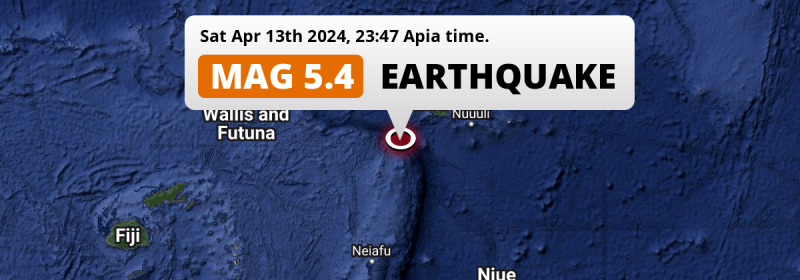
91 miles from Samoa, a shallow and significant MAG-5.3 earthquake occurred just before midnight of Saturday April 13th, 2024. American Samoa is also near its epicenter.
Felt the earthquake? Share this article: 


Earthquake Summary
This earthquake struck 91 miles (146 km) from Samoa The center of this earthquake had a very shallow depth of 10 km. Shallow earthquakes usually have a larger impact than earthquakes deep in the earth.
| Date and Time: | Apr 13, 2024 23:47 (Apia Time) - Apr 13, 2024 10:47 Universal Time. |
|---|---|
| Location: | 190 km SW of Apia, Tuamasaga, Samoa. Coordinates 15°0'37"S 173°2'30"W. |
| Map: | 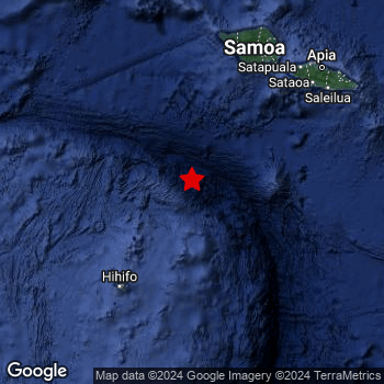 Map of area around epicenter. Click to open in Google Maps. |
| Magnitude: | MAG 5.3 Detected by 3 stations. Maximum Error Range ±0.03 . |
| Depth: | 10 km (6 mi) A very shallow depth. |
| Tsunami Risk: | Low tsunami risk Earthquakes under MAG-6.5 do not usually cause tsunami's. Always stay cautious - More info here. |
Nearby towns and cities
This earthquake struck within proximity of multiple countries. Samoa and American Samoa are both within 300km distance of its epicenter.
Located 190 kilometer (118 mi) southwest of the epicenter of this earthquake, Apia (Tuamasaga, Samoa) is the nearest significant population center.
Overview of nearby places
| Distance | Place |
|---|---|
| 190 km (118 mi) NE from epicenter |
Apia Tuamasaga, Samoa. |
| 264 km (164 mi) ENE from epicenter |
Pago Pago Eastern District, American Samoa. |
Shaking reported by 2 people
People that feel an earthquake may report their experience to the US Geographic Survey. Currently, 2 people have reported shaking in 2 places in Samoa.We keep updating this article as more ground reports become available. You may report that you felt this earthquake here.
Places with most reports:
- Apia, Apia Urban Area, Samoa: 1 person.
- Siusega, North West Upolu, Samoa: 1 person.
Aftershocks detected
In the days before this main shock, 1 smaller foreshock was detected. Nearby this earthquake a foreshock struck 8 hrs earlier. It measured a magnitude of 4.5
Overview of foreshocks and aftershocks
| Classification | Magnitude | When | Where |
|---|---|---|---|
| Foreshock | M 4.5 |
8 hrs earlier Apr 13, 2024 15:29 (Apia Time) | 85 km (53 mi) SSE from Main Shock. |
| Main Shock This Earthquake |
M 5.3 |
Apr 13, 2024 23:47 (Apia Time) | - |
More earthquakes coming?
The risk of aftershocks decreases rapidly over time. Usually, aftershocks are at least one order of magnitude lower than a main shock.
In only six percent of cases, significant earthquakes are followed by a larger main shock, making the current earthquake a foreshock. While the chance of this happening is not so large, it is adviced to maintain cautiousness in the hours and days following a major earthquake.
Read: How to Stay Safe during an Earthquake (cdc.gov).Earthquakes like this happen often in the region
Earthquakes of this strength are very common in the region. This is the strongest earthquake to hit since February 18th, 2024, when a 5.6 magnitude earthquake hit 207 km (128 mi) further southwest. An even stronger magnitude 7.6 earthquake struck on May 10th, 2023.
In total, 138 earthquakes with a magnitude of 5.3 or higher have been registered within 300km (186 mi) of this epicenter in the past 10 years. This comes down to an average of once every 26 days.
Low tsunami risk
Based on early data it appears this earthquake was not strong enough (lower than MAG-6.5) to be likely to cause destructive tsunami's. However this earthquake appeared to have hit at a shallow depth under sea, so stay cautious and monitor advice from local authorities.
Tsunami Risk Factors
| Factor | Under Sea? | MAG-6.5 or stronger? | Shallow depth? |
|---|---|---|---|
| Explanation | Almost all tsunami's are caused by earthquakes with their epicenter under sea or very near the sea. However stay cautious in coastal areas as earthquakes on land may cause landslides into sea, potentially still causing a local tsunami. | Under MAG 6.5: Very unlikely to cause a tsunami. MAG 6.5 to 7.5: Destructive tsunami's do occur, but are uncommon. Likely to observe small sea level changes. MAG 7.6+: Earthquakes with these magnitudes might produce destructive tsunami's. |
Most destructive tsunami's are caused by shallow earthquakes with a depth between 0 and 100km under the surface of the earth. Deeper tsunami's are unlikely to displace to ocean floor. |
| This Earthquake | This earthquake appears to have struck under the sea. | Not this earthquake. This earthquake had a magnitude of 5.3. Earthquakes of this strength are unlikely to trigger a tsunami. |
This earthquake occurred at a depth of of 10 km (6 mi). Earthquakes this shallow could trigger a tsunami. |
Sources
Last updated 02/05/24 12:28 (). This article contains currently available information about the earthquake and is automatically composed. We continue to update this article up to a few days after the earthquake occurred.
- US Geographic Society (USGS): Earthquake us7000mbw6
- European-Mediterranean Seismological Centre (EMSC): Earthquake 20240413_0000126
- Geonames.org: World Cities Database
- Google Maps: Static API
- Earthquakelist.org: Historic Earthquakes Database
Share this article:
