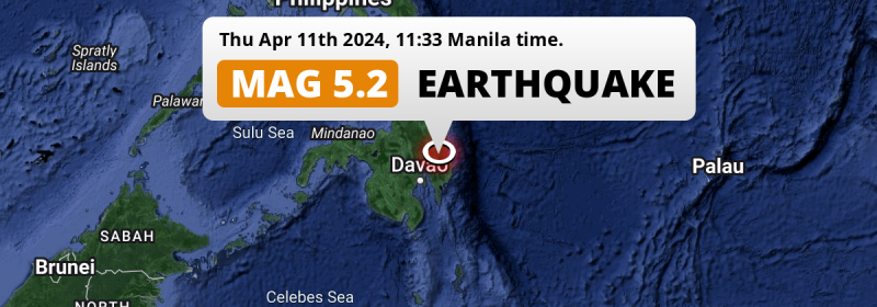
Around noon of Thursday April 11th, 2024, a shallow and significant MAG-5.2 earthquake hit under land 9 kilometer from Compostela in The Philippines.
Felt the earthquake? Share this article: 


Earthquake Summary
The earthquake struck on land in The Philippines, 9 kilometer (6 mi) east-southeast of Compostela in Davao. The center of this earthquake had a very shallow depth of 10 km. Shallow earthquakes usually have a larger impact than earthquakes deep in the earth.
| Date and Time: | Apr 11, 2024 11:33AM (Manila Time) - Apr 11, 2024 03:33 Universal Time. |
|---|---|
| Location: | 9 km ESE of Compostela, Davao, The Philippines. Coordinates 7°38'42"N 126°9'49"E. |
| Map: | 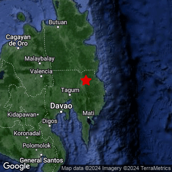 Map of area around epicenter. Click to open in Google Maps. |
| Magnitude: | MAG 5.2 Detected by 20 stations. Maximum Error Range ±0.069 . |
| Depth: | 10 km (6 mi) A very shallow depth. |
| Tsunami Risk: | Tsunami very unlikely While this was a shallow earthquake, it appears to have occurred under land with a magnitude not strong enough to cause tsunami's. Always stay cautious - More info here. |
Nearby towns and cities
This earthquake may have been felt in The Philippines . The closest significant population center near the earthquake is Compostela in Davao, The Philippines. Compostela is located 9 kilometer (6 mi) east-southeast of the epicenter.
Multiple large cities are in proximity of today's earthquake. Davao is located 88 km to the southwest. Budta is located 196 km to the west-southwest. Malingao is located 194 km to the west-southwest.
A complete list of nearby places is included below.
Overview of nearby places
| Distance | Place |
|---|---|
| 9 km (6 mi) WNW from epicenter |
Compostela Davao, The Philippines. |
| 22 km (14 mi) NNW from epicenter |
Monkayo Davao, The Philippines. |
| 22 km (14 mi) W from epicenter |
Nabunturan Davao, The Philippines. |
| 24 km (15 mi) SW from epicenter |
San Mariano Davao, The Philippines. |
| 38 km (24 mi) W from epicenter |
New Corella Davao, The Philippines. |
| 45 km (28 mi) WSW from epicenter |
Magugpo Poblacion Davao, The Philippines. |
| 46 km (29 mi) NNW from epicenter |
Trento Caraga, The Philippines. |
| 53 km (33 mi) NNW from epicenter |
Veruela Caraga, The Philippines. |
| 54 km (34 mi) WSW from epicenter |
Cabayangan Davao, The Philippines. |
| 61 km (38 mi) NNW from epicenter |
Bunawan Caraga, The Philippines. |
| 63 km (39 mi) SE from epicenter |
Manay Davao, The Philippines. |
| 65 km (40 mi) SW from epicenter |
Panabo Davao, The Philippines. |
| 66 km (41 mi) NNE from epicenter |
Bislig Caraga, The Philippines. |
| 77 km (48 mi) S from epicenter |
Mati Davao, The Philippines. |
| 81 km (50 mi) SW from epicenter |
Samal Davao, The Philippines. |
| 85 km (53 mi) S from epicenter |
Lupon Davao, The Philippines. |
| 88 km (55 mi) SW from epicenter |
Davao Davao, The Philippines. |
| 99 km (62 mi) NNW from epicenter |
Talacogon Caraga, The Philippines. |
| 102 km (63 mi) NNW from epicenter |
San Francisco Caraga, The Philippines. |
| 110 km (68 mi) NNW from epicenter |
Bah-Bah Caraga, The Philippines. |
| 118 km (73 mi) W from epicenter |
Quezon Northern Mindanao, The Philippines. |
| 121 km (75 mi) WNW from epicenter |
NIA Valencia Northern Mindanao, The Philippines. |
| 128 km (80 mi) WNW from epicenter |
Malaybalay Northern Mindanao, The Philippines. |
| 128 km (80 mi) W from epicenter |
Don Carlos Northern Mindanao, The Philippines. |
| 128 km (80 mi) W from epicenter |
Maramag Northern Mindanao, The Philippines. |
| 131 km (81 mi) NNW from epicenter |
Bayugan Caraga, The Philippines. |
| 134 km (83 mi) SW from epicenter |
Digos Davao, The Philippines. |
| 138 km (86 mi) WSW from epicenter |
Kidapawan Soccsksargen, The Philippines. |
| 142 km (88 mi) SW from epicenter |
Bansalan Davao, The Philippines. |
| 150 km (93 mi) SSW from epicenter |
Malita Davao, The Philippines. |
| 159 km (99 mi) WSW from epicenter |
Kabacan Soccsksargen, The Philippines. |
| 159 km (99 mi) N from epicenter |
Tandag Caraga, The Philippines. |
| 160 km (99 mi) NNW from epicenter |
Butuan Caraga, The Philippines. |
| 162 km (101 mi) NNW from epicenter |
Libertad Caraga, The Philippines. |
| 170 km (106 mi) NNW from epicenter |
Buenavista Caraga, The Philippines. |
| 175 km (109 mi) NW from epicenter |
Mariano Northern Mindanao, The Philippines. |
| 180 km (112 mi) SSW from epicenter |
Maluñgun Soccsksargen, The Philippines. |
| 182 km (113 mi) WNW from epicenter |
Bugo Northern Mindanao, The Philippines. |
| 191 km (119 mi) WNW from epicenter |
Cagayan de Oro Northern Mindanao, The Philippines. |
| 193 km (120 mi) SW from epicenter |
Koronadal Soccsksargen, The Philippines. |
| 194 km (121 mi) WSW from epicenter |
Malingao Soccsksargen, The Philippines. |
| 195 km (121 mi) WSW from epicenter |
Tacurong Soccsksargen, The Philippines. |
| 196 km (122 mi) WSW from epicenter |
Budta Rehiyong Autonomo sa Muslim na Mindanao, The Philippines. |
| 197 km (122 mi) SSW from epicenter |
Alabel Soccsksargen, The Philippines. |
| 199 km (124 mi) SW from epicenter |
Polomolok Soccsksargen, The Philippines. |
| 203 km (126 mi) SSW from epicenter |
General Santos Soccsksargen, The Philippines. |
| 206 km (128 mi) WNW from epicenter |
Iligan City Soccsksargen, The Philippines. |
| 211 km (131 mi) W from epicenter |
Marawi City Rehiyong Autonomo sa Muslim na Mindanao, The Philippines. |
| 217 km (135 mi) WSW from epicenter |
Cotabato Rehiyong Autonomo sa Muslim na Mindanao, The Philippines. |
| 221 km (137 mi) WNW from epicenter |
Iligan Northern Mindanao, The Philippines. |
| 222 km (138 mi) WNW from epicenter |
Mantampay Northern Mindanao, The Philippines. |
| 297 km (185 mi) W from epicenter |
Muricay Zamboanga Peninsula, The Philippines. |
| 298 km (185 mi) NW from epicenter |
Jagna Central Visayas, The Philippines. |
Shaking reported by 19 people
People that feel an earthquake may report their experience to the US Geographic Survey. Currently, 19 people have reported shaking in 9 places, all within Philippines.We keep updating this article as more ground reports become available. You may report that you felt this earthquake here.
Places with most reports:
- Digos, Southern Mindanao, Philippines: 6 people.
- Canocotan, Southern Mindanao, Philippines: 4 people.
- Dumaguete, Central Visayas, Philippines: 2 people.
- Davao, Southern Mindanao, Philippines: 2 people.
- Rosario, Caraga, Philippines: 1 person.
- Bantacan, Southern Mindanao, Philippines: 1 person.
- Compostela, Southern Mindanao, Philippines: 1 person.
- Mawab, Southern Mindanao, Philippines: 1 person.
- New Sibonga, Southern Mindanao, Philippines: 1 person.
7 Aftershocks detected
After this earthquake struck, 7 smaller aftershocks occurred. Just 18 hrs after this main shock, an earthquake measuring MAG-3.6 was detected 11 km (7 mi) south-southwest of this earthquake.
This main shock was prefaced by 3 smaller foreshocks. A 3.5 magnitude earthquake hit 2 days earlier nearby.
Overview of foreshocks and aftershocks
| Classification | Magnitude | When | Where |
|---|---|---|---|
| Foreshock | M 3.3 |
2 days earlier Apr 9, 2024 05:26AM (Manila Time) | 33 km (20 mi) E from Main Shock. |
| Foreshock | M 3.1 |
2 days earlier Apr 9, 2024 06:19PM (Manila Time) | 93 km (58 mi) NE from Main Shock. |
| Foreshock | M 3.5 |
2 days earlier Apr 9, 2024 06:25PM (Manila Time) | 76 km (47 mi) NE from Main Shock. |
| Main Shock This Earthquake |
M 5.2 |
Apr 11, 2024 11:33AM (Manila Time) | - |
| Aftershock | M 3.3 |
32 mins later Apr 11, 2024 12:05PM (Manila Time) | 40 km (25 mi) NNE from Main Shock. |
| Aftershock | M 3.2 |
1 hr later Apr 11, 2024 12:44PM (Manila Time) | 15 km (9 mi) WSW from Main Shock. |
| Aftershock | M 3.5 |
2 hrs later Apr 11, 2024 01:22PM (Manila Time) | 13 km (8 mi) SSW from Main Shock. |
| Aftershock | M 3.0 |
13 hrs later Apr 12, 2024 12:13AM (Manila Time) | 11 km (7 mi) SSW from Main Shock. |
| Aftershock | M 3.2 |
14 hrs later Apr 12, 2024 01:08AM (Manila Time) | 100 km (62 mi) NE from Main Shock. |
| Aftershock | M 3.6 |
18 hrs later Apr 12, 2024 05:09AM (Manila Time) | 11 km (7 mi) SSW from Main Shock. |
| Aftershock | M 3.0 |
1 day later Apr 12, 2024 02:39PM (Manila Time) | 68 km (42 mi) NE from Main Shock. |
More earthquakes coming?
The risk of aftershocks decreases rapidly over time. Usually, aftershocks are at least one order of magnitude lower than a main shock.
The chance that a significant earthquake like this one is followed by an even larger earthquake is not so large. On average, scientists estimate a 94% chance that a major earthquake will not be followed by an even larger one. It is still adviced to be aware of this risk
Read: How to Stay Safe during an Earthquake (cdc.gov).Earthquakes like this happen often in the region
Earthquakes of this strength are very common in the region. This is the strongest earthquake to hit since March 8th, 2024, when a 6 magnitude earthquake hit 221 km (137 mi) further south-southeast. An even stronger magnitude 7.6 earthquake struck on December 2nd, 2023.
In total, 193 earthquakes with a magnitude of 5.2 or higher have been registered within 300km (186 mi) of this epicenter in the past 10 years. This comes down to an average of once every 19 days.
Tsunami very unlikely
While MAG-6.5+ earthquakes may cause tsunami's, it appears that the epicenter of this earthquake hit under land. In addition, the reported depth is deeper than 100km, making the risk of a tsunami even less likely. However always stay cautious and monitor advice from local authorities.
Tsunami Risk Factors
| Factor | Under Sea? | MAG-6.5 or stronger? | Shallow depth? |
|---|---|---|---|
| Explanation | Almost all tsunami's are caused by earthquakes with their epicenter under sea or very near the sea. However stay cautious in coastal areas as earthquakes on land may cause landslides into sea, potentially still causing a local tsunami. | Under MAG 6.5: Very unlikely to cause a tsunami. MAG 6.5 to 7.5: Destructive tsunami's do occur, but are uncommon. Likely to observe small sea level changes. MAG 7.6+: Earthquakes with these magnitudes might produce destructive tsunami's. |
Most destructive tsunami's are caused by shallow earthquakes with a depth between 0 and 100km under the surface of the earth. Deeper tsunami's are unlikely to displace to ocean floor. |
| This Earthquake | Not this earthquake. This earthquake appears to have struck on land far from any coast. |
Not this earthquake. This earthquake had a magnitude of 5.2. Earthquakes of this strength are unlikely to trigger a tsunami. |
This earthquake occurred at a depth of of 10 km (6 mi). Earthquakes this shallow could trigger a tsunami. |
Sources
Last updated 04/05/24 00:38 (). This article contains currently available information about the earthquake and is automatically composed. We continue to update this article up to a few days after the earthquake occurred.
- US Geographic Society (USGS): Earthquake us7000mbbc
- European-Mediterranean Seismological Centre (EMSC): Earthquake 20240411_0000032
- Geonames.org: World Cities Database
- Google Maps: Static API
- Earthquakelist.org: Historic Earthquakes Database
Share this article:
