Under land 41 kilometer from Kuqa in China, a shallow and significant MAG-5.4 earthquake occurred in the evening of Wednesday April 10th, 2024. Earthquakes like this can cause significant economic damage but are usually unlikely to result on large numbers of fatalities.
Felt the earthquake? Share this article: 


Earthquake Summary
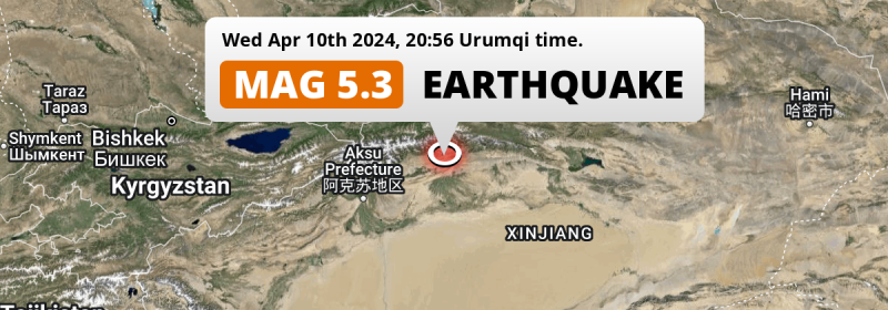
The earthquake struck on land in China, 41 kilometer (25 mi) northwest of Kuqa in Xinjiang. The center of this earthquake had a very shallow depth of 7 km. Shallow earthquakes usually have a larger impact than earthquakes deep in the earth.
| Date and Time: | Apr 10, 2024 20:56 (Urumqi Time) - Apr 10, 2024 14:56 Universal Time. |
|---|---|
| Location: | 41 km NW of Kuqa, Xinjiang, China. Coordinates 42°0'41"N 82°38'30"E. |
| Map: | 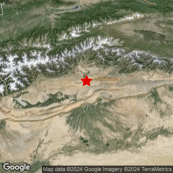 Map of area around epicenter. Click to open in Google Maps. |
| Magnitude: | MAG 5.4 Detected by 14 stations. Maximum Error Range ±0.083 . |
| Depth: | 7 km (4 mi) A very shallow depth. |
| Max. Intensity: | VII
Very Strong On the Modified Mercalli Scale. |
| Tsunami Risk: | Tsunami very unlikely While this was a shallow earthquake, it appears to have occurred under land with a magnitude not strong enough to cause tsunami's. Always stay cautious - More info here. |
Significant economic impact
Based on scientific estimates by the US Geographic Survey (USGS), the risk of high fatalities for this earthquake is classified at level GREEN (low). They expect an 65% likelyhood of between 0 and 1 fatalities, and a 96% chance that the number of fatalities falls no higher than 10.
The USGS classifies the economic impact of this earthquake at level YELLOW (significant). They expect an 35% likelyhood of between 1 and 10 million US Dollars in economic damage and impact, and a 90% chance that the economic impact of this earthquake falls no higher than 100 million USD.
Roughly 2.9 million people exposed to shaking
This earthquake may have been felt by around 2.9 million people. That is the expected population size of the area exposed to a level of shaking of II or higher on the Modified Mercalli scale according to the USGS.
Strong shaking and probably light damage may have been experienced by an estimated 4,140 people. At VI, it is the highest MMI level this earthquake has caused. Intensity level III was experienced by the majority of people (around 1.8 million). In their region, weak shaking and probably no damage can be expected.
People in 2 countries have been exposed to shaking. In China , around 2.9 million people, with impact levels up to VI (strong shaking, probably light damage). In Kazakhstan, shaking was experienced too.
| People | MMI Level | Shaking | Damage |
|---|---|---|---|
| 0 | I |
Not noticable | None |
| 950 | II |
Very weak | None |
| 1,812,000 | III |
Weak | Probably none |
| 1,104,000 | IV |
Light | Likely none |
| 21,260 | V |
Moderate | Very light |
| 4,140 | VI |
Strong | Light |
| 0 | VII |
Very Strong | Moderate |
| 0 | VIII |
Severe | Moderate to heavy |
| 0 | IX |
Violent | Heavy |
| 0 | X |
Extreme | Very heavy |
Nearby towns and cities
This earthquake may have been felt in China . Located 41 kilometer (25 mi) northwest of the epicenter of this earthquake, Kuqa (Xinjiang, China) is the nearest significant population center. The intensity of shaking and damage in Kuqa is estimated to be around level IV on the Modified Mercalli Intensity scale (light shaking, likely no damage).
Multiple major population centers exist within 300km of the earthquake that struck today. Kuqa is located 41 km to the south-east and experienced an intensity of IV (light shaking, likely no damage). Aksu is located 217 km to the west-southwest (intensity unknown, possibly low). Korla is located 292 km to the east (intensity unknown, possibly low).
The table below provides an overview of all places in proximity of today's earthquake. Where available, the estimated intensity on the Modified Mercalli Intensity Scale in each place is included. Places where this information is omitted likely experienced little impact.
Overview of nearby places
| Distance | Place | Intensity (MMI) |
|---|---|---|
| 41 km (25 mi) SE from epicenter |
Kuqa Xinjiang, China. |
IV
Light |
| 165 km (103 mi) NNE from epicenter |
Xinyuan Xinjiang, China. |
III
Weak |
| 192 km (119 mi) NNW from epicenter |
Kax Xinjiang, China. |
III
Weak |
| 198 km (123 mi) NNW from epicenter |
Baytokay Xinjiang, China. |
III
Weak |
| 200 km (124 mi) SW from epicenter |
Aral Xinjiang, China. |
III
Weak |
| 200 km (124 mi) NNW from epicenter |
Samuyuzi Xinjiang, China. |
III
Weak |
| 204 km (127 mi) NNW from epicenter |
Weiwu'eryuqiwen Xinjiang, China. |
III
Weak |
| 209 km (130 mi) NNW from epicenter |
Yengitam Xinjiang, China. |
III
Weak |
| 216 km (134 mi) NNW from epicenter |
Onyar Xinjiang, China. |
|
| 217 km (135 mi) WSW from epicenter |
Aksu Xinjiang, China. |
|
| 218 km (135 mi) NNW from epicenter |
Arewusitang Xinjiang, China. |
|
| 223 km (139 mi) NNW from epicenter |
Yuqunweng Xinjiang, China. |
|
| 227 km (141 mi) NNW from epicenter |
Awuliya Xinjiang, China. |
|
| 235 km (146 mi) NNW from epicenter |
Yili Xinjiang, China. |
|
| 235 km (146 mi) NNW from epicenter |
Hudiyuzi Xinjiang, China. |
|
| 236 km (147 mi) NNW from epicenter |
Qapqal Xinjiang, China. |
|
| 236 km (147 mi) NNW from epicenter |
Taxkowrük Xinjiang, China. |
|
| 236 km (147 mi) NNW from epicenter |
Jelilyüzi Xinjiang, China. |
|
| 243 km (151 mi) NNW from epicenter |
Panjim Xinjiang, China. |
|
| 244 km (152 mi) NNW from epicenter |
Dadamtu Xinjiang, China. |
|
| 245 km (152 mi) NNW from epicenter |
Bayandai Xinjiang, China. |
|
| 269 km (167 mi) NNW from epicenter |
Huocheng Xinjiang, China. |
|
| 292 km (181 mi) E from epicenter |
Korla Xinjiang, China. |
Earthquake Intensity Map
The maximum intensity (MMI Scale) caused by this earthquake is VII. The map below shows in which areas this earthquake was the most and least impactful. It is based on data from the US Geographic Survey.

2 Aftershocks detected
After this earthquake struck, 2 smaller aftershocks occurred. At a distance of 5 km (2.9 mi) south-southeast of this earthquake, an aftershock struck 4 hrs later. It measured a magnitude of 4.6
In the days before this main shock, 6 smaller foreshocks were detected. Roughly 4 hrs before this earthquake, a foreshock measuring MAG-5 was detected nearby this earthquake.
Overview of foreshocks and aftershocks
| Classification | Magnitude | When | Where |
|---|---|---|---|
| Foreshock | M 3.0 |
3 days earlier Apr 7, 2024 21:41 (Urumqi Time) | 81 km (50 mi) NE from Main Shock. |
| Foreshock | M 5.0 |
3 days earlier Apr 8, 2024 02:47 (Urumqi Time) | 44 km (27 mi) WSW from Main Shock. |
| Foreshock | M 4.5 |
3 days earlier Apr 8, 2024 05:16 (Urumqi Time) | 33 km (20 mi) WSW from Main Shock. |
| Foreshock | M 4.0 |
3 days earlier Apr 8, 2024 05:20 (Urumqi Time) | 35 km (22 mi) SW from Main Shock. |
| Foreshock | M 4.3 |
1 day earlier Apr 9, 2024 10:10 (Urumqi Time) | 81 km (50 mi) ENE from Main Shock. |
| Foreshock | M 5.0 |
4 hrs earlier Apr 10, 2024 16:57 (Urumqi Time) | 22 km (14 mi) SW from Main Shock. |
| Main Shock This Earthquake |
M 5.4 |
Apr 10, 2024 20:56 (Urumqi Time) | - |
| Aftershock | M 4.6 |
4 hrs later Apr 11, 2024 00:53 (Urumqi Time) | 5 km (2.9 mi) SSE from Main Shock. |
| Aftershock | M 4.4 |
10 hrs later Apr 11, 2024 06:42 (Urumqi Time) | 21 km (13 mi) SSE from Main Shock. |
More earthquakes coming?
The risk of aftershocks decreases rapidly over time. Usually, aftershocks are at least one order of magnitude lower than a main shock.
It's always adviced to be cautious of the risk of a larger shock following any significant earthquake, however this risk is fairly small. There is a roughly 94 percent change that no larger main shock will follow in the days following this earthquake.
Read: How to Stay Safe during an Earthquake (cdc.gov).Earthquakes like this are common in the region
Earthquakes of this strength occur quite regularly in the region. This is the strongest earthquake to hit since January 29th, 2023, when a 5.7 magnitude earthquake hit 223 km (139 mi) further south. An even stronger magnitude 6.3 earthquake struck on August 8th, 2017.
In total, 4 earthquakes with a magnitude of 5.4 or higher have been registered within 300km (186 mi) of this epicenter in the past 10 years. This comes down to an average of once every 3 years.
Tsunami very unlikely
While MAG-6.5+ earthquakes may cause tsunami's, it appears that the epicenter of this earthquake hit under land. In addition, the reported depth is deeper than 100km, making the risk of a tsunami even less likely. However always stay cautious and monitor advice from local authorities.
Tsunami Risk Factors
| Factor | Under Sea? | MAG-6.5 or stronger? | Shallow depth? |
|---|---|---|---|
| Explanation | Almost all tsunami's are caused by earthquakes with their epicenter under sea or very near the sea. However stay cautious in coastal areas as earthquakes on land may cause landslides into sea, potentially still causing a local tsunami. | Under MAG 6.5: Very unlikely to cause a tsunami. MAG 6.5 to 7.5: Destructive tsunami's do occur, but are uncommon. Likely to observe small sea level changes. MAG 7.6+: Earthquakes with these magnitudes might produce destructive tsunami's. |
Most destructive tsunami's are caused by shallow earthquakes with a depth between 0 and 100km under the surface of the earth. Deeper tsunami's are unlikely to displace to ocean floor. |
| This Earthquake | Not this earthquake. This earthquake appears to have struck on land far from any coast. |
Not this earthquake. This earthquake had a magnitude of 5.4. Earthquakes of this strength are unlikely to trigger a tsunami. |
This earthquake occurred at a depth of of 7 km (4 mi). Earthquakes this shallow could trigger a tsunami. |
Sources
Last updated 03/05/24 17:38 (). This article contains currently available information about the earthquake and is automatically composed. We continue to update this article up to a few days after the earthquake occurred.
- US Geographic Society (USGS): Earthquake us7000mb76
- European-Mediterranean Seismological Centre (EMSC): Earthquake 20240410_0000165
- Geonames.org: World Cities Database
- Google Maps: Static API
- Earthquakelist.org: Historic Earthquakes Database
Share this article:
