A Magnitude 4.9 aftershock struck under land 103 kilometer from Mount Hagen in Papua New Guinea in the early morning of Monday April 8th, 2024.
Felt the earthquake? Share this article: 


Earthquake Summary
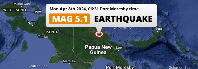
The earthquake struck on land in Papua New Guinea, 103 kilometer (64 mi) north of Mount Hagen in Western Highlands. The center of this earthquake had an intermediate depth of 91 km.
| Date and Time: | Apr 8, 2024 06:31 (Port Moresby Time) - Apr 7, 2024 20:31 Universal Time. |
|---|---|
| Location: | 103 km north of Mount Hagen, Western Highlands, Papua New Guinea. Coordinates 4°56'5"S 144°16'16"E. |
| Map: | 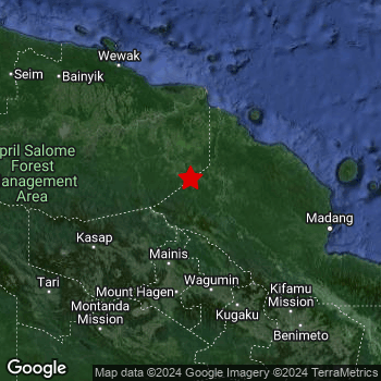 Map of area around epicenter. Click to open in Google Maps. |
| Magnitude: | MAG 4.9 Detected by 154 stations. Maximum Error Range ±0.045 . |
| Depth: | 91 km (57 mi) An intermediate depth. |
| Tsunami Risk: | Tsunami very unlikely While this was a shallow earthquake, it appears to have occurred under land with a magnitude not strong enough to cause tsunami's. Always stay cautious - More info here. |
Nearby towns and cities
This earthquake may have been felt in Papua New Guinea . Located 103 kilometer (64 mi) north of the epicenter of this earthquake, Mount Hagen (Western Highlands, Papua New Guinea) is the nearest significant population center.
An overview of nearby towns and cities is available in the overview below.
Overview of nearby places
| Distance | Place |
|---|---|
| 103 km (64 mi) S from epicenter |
Mount Hagen Western Highlands, Papua New Guinea. |
| 151 km (94 mi) SSW from epicenter |
Mendi Southern Highlands, Papua New Guinea. |
| 170 km (106 mi) NNW from epicenter |
Wewak East Sepik, Papua New Guinea. |
| 171 km (106 mi) E from epicenter |
Madang Madang, Papua New Guinea. |
| 178 km (111 mi) SE from epicenter |
Goroka Eastern Highlands, Papua New Guinea. |
Shaking reported by 1 person
People that feel an earthquake may report their experience to the US Geographic Survey. Currently, 1 person has reported shaking in one place in Papua New Guinea.We keep updating this article as more ground reports become available. You may report that you felt this earthquake here.
Places with most reports:
- Mount Hagen, Western Highlands, Papua New Guinea: 1 person.
This is likely an aftershock
This earthquake was an aftershock. A larger mag. 5.1 earthquake struck 12 km (7 mi) north-east in advance of this 4.9 earthquake around 10 sec earlier.
Overview of foreshocks and aftershocks
| Classification | Magnitude | When | Where |
|---|---|---|---|
| Main Shock | M 5.1 |
Apr 8, 2024 06:31 (Port Moresby Time) | - |
| Aftershock This Earthquake |
M 4.9 |
10 sec later Apr 8, 2024 06:31 (Port Moresby Time) | 12 km (7 mi) SW from Main Shock. |
| Aftershock | M 4.1 |
2 days later Apr 10, 2024 14:36 (Port Moresby Time) | 44 km (27 mi) NE from Main Shock. |
More earthquakes coming?
The risk of aftershocks decreases rapidly over time. Usually, aftershocks are at least one order of magnitude lower than a main shock.
In only six percent of cases, significant earthquakes are followed by a larger main shock, making the current earthquake a foreshock. While the chance of this happening is not so large, it is adviced to maintain cautiousness in the hours and days following a major earthquake.
Read: How to Stay Safe during an Earthquake (cdc.gov).Earthquakes like this happen often in the region
Earthquakes of this strength are very common in the region. In total, 339 earthquakes with a magnitude of 4.9 or higher have been registered within 300km (186 mi) of this epicenter in the past 10 years. This comes down to an average of once every 11 days.
Tsunami very unlikely
While MAG-6.5+ earthquakes may cause tsunami's, it appears that the epicenter of this earthquake hit under land. In addition, the reported depth is deeper than 100km, making the risk of a tsunami even less likely. However always stay cautious and monitor advice from local authorities.
Tsunami Risk Factors
| Factor | Under Sea? | MAG-6.5 or stronger? | Shallow depth? |
|---|---|---|---|
| Explanation | Almost all tsunami's are caused by earthquakes with their epicenter under sea or very near the sea. However stay cautious in coastal areas as earthquakes on land may cause landslides into sea, potentially still causing a local tsunami. | Under MAG 6.5: Very unlikely to cause a tsunami. MAG 6.5 to 7.5: Destructive tsunami's do occur, but are uncommon. Likely to observe small sea level changes. MAG 7.6+: Earthquakes with these magnitudes might produce destructive tsunami's. |
Most destructive tsunami's are caused by shallow earthquakes with a depth between 0 and 100km under the surface of the earth. Deeper tsunami's are unlikely to displace to ocean floor. |
| This Earthquake | Not this earthquake. This earthquake appears to have struck on land far from any coast. |
Not this earthquake. This earthquake had a magnitude of 4.9. Earthquakes of this strength are unlikely to trigger a tsunami. |
This earthquake occurred at a depth of of 91 km (57 mi). Earthquakes this shallow could trigger a tsunami. |
Sources
Last updated 04/05/24 00:18 (). As more information on this earthquake becomes available this article will be updated. This article is automatically composed based on data originating from multiple sources.
- US Geographic Society (USGS): Earthquake us7000manr
- Geonames.org: World Cities Database
- Google Maps: Static API
- Earthquakelist.org: Historic Earthquakes Database
Share this article:
