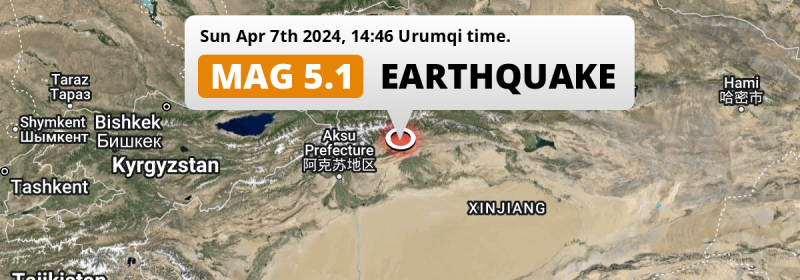
A shallow and significant Magnitude 5.1 earthquake struck under land 58 kilometer from Kuqa in China in the afternoon of Sunday April 7th, 2024.
Felt the earthquake? Share this article: 


Earthquake Summary
The earthquake struck on land in China, 58 kilometer (36 mi) west-northwest of Kuqa in Xinjiang. The center of this earthquake had a very shallow depth of 10 km. Shallow earthquakes usually have a larger impact than earthquakes deep in the earth.
| Date and Time: | Apr 7, 2024 14:46 (Urumqi Time) - Apr 7, 2024 08:46 Universal Time. |
|---|---|
| Location: | 58 km WNW of Kuqa, Xinjiang, China. Coordinates 41°53'44"N 82°16'8"E. |
| Map: | 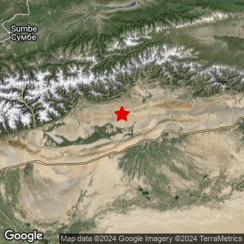 Map of area around epicenter. Click to open in Google Maps. |
| Magnitude: | MAG 5.1 Detected by 212 stations. Maximum Error Range ±0.039 . |
| Depth: | 10 km (6 mi) A very shallow depth. |
| Tsunami Risk: | Tsunami very unlikely While this was a shallow earthquake, it appears to have occurred under land with a magnitude not strong enough to cause tsunami's. Always stay cautious - More info here. |
Nearby towns and cities
This earthquake may have been felt in China . Kuqa in Xinjiang, China is the nearest significant place from the epicenter. The earthquake occurred 58 kilometer (36 mi) west-northwest of Kuqa.
Major cities near this earthquake: Aksu is located 184 km to the west-southwest. Kuqa is located 58 km to the east-southeast. Aral is located 172 km to the south-southwest.
The table below provides an overview of all places in proximity of today's earthquake.
Overview of nearby places
| Distance | Place |
|---|---|
| 58 km (36 mi) ESE from epicenter |
Kuqa Xinjiang, China. |
| 172 km (107 mi) SSW from epicenter |
Aral Xinjiang, China. |
| 184 km (114 mi) WSW from epicenter |
Aksu Xinjiang, China. |
| 188 km (117 mi) NNE from epicenter |
Xinyuan Xinjiang, China. |
| 197 km (122 mi) N from epicenter |
Kax Xinjiang, China. |
| 202 km (126 mi) NNW from epicenter |
Baytokay Xinjiang, China. |
| 205 km (127 mi) N from epicenter |
Samuyuzi Xinjiang, China. |
| 210 km (130 mi) N from epicenter |
Weiwu'eryuqiwen Xinjiang, China. |
| 212 km (132 mi) NNW from epicenter |
Yengitam Xinjiang, China. |
| 220 km (137 mi) NNW from epicenter |
Arewusitang Xinjiang, China. |
| 221 km (137 mi) N from epicenter |
Onyar Xinjiang, China. |
| 226 km (140 mi) NNW from epicenter |
Yuqunweng Xinjiang, China. |
| 231 km (144 mi) NNW from epicenter |
Awuliya Xinjiang, China. |
| 233 km (145 mi) NNW from epicenter |
Qapqal Xinjiang, China. |
| 235 km (146 mi) NNW from epicenter |
Yili Xinjiang, China. |
| 235 km (146 mi) NNW from epicenter |
Taxkowrük Xinjiang, China. |
| 236 km (147 mi) NNW from epicenter |
Hudiyuzi Xinjiang, China. |
| 239 km (149 mi) NNW from epicenter |
Jelilyüzi Xinjiang, China. |
| 244 km (152 mi) NNW from epicenter |
Dadamtu Xinjiang, China. |
| 245 km (152 mi) NNW from epicenter |
Bayandai Xinjiang, China. |
| 245 km (152 mi) NNW from epicenter |
Panjim Xinjiang, China. |
| 265 km (165 mi) NNW from epicenter |
Huocheng Xinjiang, China. |
Shaking reported by 1 person
People that feel an earthquake may report their experience to the US Geographic Survey. Currently, 1 person has reported shaking in one place in Kazakhstan.We keep updating this article as more ground reports become available. You may report that you felt this earthquake here.
Places with most reports:
- Almaty, Almaty, Kazakhstan: 1 person.
6 Aftershocks detected
Since this main shock, 6 smaller aftershocks were detected. Just 12 hrs after this main shock, an earthquake measuring MAG-5 was detected 11 km (7 mi) west-southwest of this earthquake.
Before this earthquake struck, 1 smaller foreshock occurred. A 4.6 magnitude earthquake hit 2 mins earlier nearby.
Overview of foreshocks and aftershocks
| Classification | Magnitude | When | Where |
|---|---|---|---|
| Foreshock | M 4.6 |
2 mins earlier Apr 7, 2024 14:44 (Urumqi Time) | 11 km (7 mi) S from Main Shock. |
| Main Shock This Earthquake |
M 5.1 |
Apr 7, 2024 14:46 (Urumqi Time) | - |
| Aftershock | M 4.3 |
59 mins later Apr 7, 2024 15:45 (Urumqi Time) | 20 km (12 mi) ESE from Main Shock. |
| Aftershock | M 4.5 |
2 hrs later Apr 7, 2024 17:03 (Urumqi Time) | 6 km (4 mi) ENE from Main Shock. |
| Aftershock | M 4.3 |
6 hrs later Apr 7, 2024 20:20 (Urumqi Time) | 26 km (16 mi) SE from Main Shock. |
| Aftershock | M 5.0 |
12 hrs later Apr 8, 2024 02:47 (Urumqi Time) | 11 km (7 mi) WSW from Main Shock. |
| Aftershock | M 4.5 |
15 hrs later Apr 8, 2024 05:16 (Urumqi Time) | 2.4 km (1.5 mi) SE from Main Shock. |
| Aftershock | M 4.0 |
15 hrs later Apr 8, 2024 05:20 (Urumqi Time) | 17 km (10 mi) SSE from Main Shock. |
More earthquakes coming?
Aftershocks are usually at least 1 order of magnitude less strong than main shocks. The more time passes, the smaller the chance and likely strength of any potential aftershocks.
In only six percent of cases, significant earthquakes are followed by a larger main shock, making the current earthquake a foreshock. While the chance of this happening is not so large, it is adviced to maintain cautiousness in the hours and days following a major earthquake.
Read: How to Stay Safe during an Earthquake (cdc.gov).Earthquakes like this are common in the region
Earthquakes of this strength occur quite regularly in the region. This is the strongest earthquake to hit since January 25th, 2024, when a 5.3 magnitude earthquake hit 292 km (181 mi) further west-southwest. An even stronger magnitude 6.3 earthquake struck on August 8th, 2017.
In total, 11 earthquakes with a magnitude of 5.1 or higher have been registered within 300km (186 mi) of this epicenter in the past 10 years. This comes down to an average of once every year.
Tsunami very unlikely
While MAG-6.5+ earthquakes may cause tsunami's, it appears that the epicenter of this earthquake hit under land. In addition, the reported depth is deeper than 100km, making the risk of a tsunami even less likely. However always stay cautious and monitor advice from local authorities.
Tsunami Risk Factors
| Factor | Under Sea? | MAG-6.5 or stronger? | Shallow depth? |
|---|---|---|---|
| Explanation | Almost all tsunami's are caused by earthquakes with their epicenter under sea or very near the sea. However stay cautious in coastal areas as earthquakes on land may cause landslides into sea, potentially still causing a local tsunami. | Under MAG 6.5: Very unlikely to cause a tsunami. MAG 6.5 to 7.5: Destructive tsunami's do occur, but are uncommon. Likely to observe small sea level changes. MAG 7.6+: Earthquakes with these magnitudes might produce destructive tsunami's. |
Most destructive tsunami's are caused by shallow earthquakes with a depth between 0 and 100km under the surface of the earth. Deeper tsunami's are unlikely to displace to ocean floor. |
| This Earthquake | Not this earthquake. This earthquake appears to have struck on land far from any coast. |
Not this earthquake. This earthquake had a magnitude of 5.1. Earthquakes of this strength are unlikely to trigger a tsunami. |
This earthquake occurred at a depth of of 10 km (6 mi). Earthquakes this shallow could trigger a tsunami. |
Sources
Last updated 04/05/24 01:38 (). This article contains currently available information about the earthquake and is automatically composed. We continue to update this article up to a few days after the earthquake occurred.
- US Geographic Society (USGS): Earthquake us7000makt
- European-Mediterranean Seismological Centre (EMSC): Earthquake 20240407_0000099
- Geonames.org: World Cities Database
- Google Maps: Static API
- Earthquakelist.org: Historic Earthquakes Database
Share this article:
