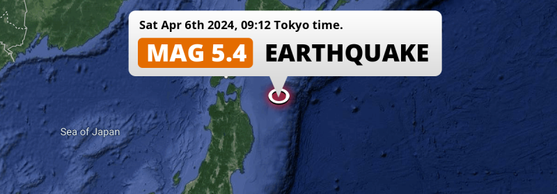
In the North Pacific Ocean 151 kilometer from Hachinohe, Japan, a shallow and significant Magnitude 5.4 earthquake occurred in the morning of Saturday April 6th, 2024. Roughly 2.1 million people may have felt this earthquake.
Felt the earthquake? Share this article: 


Earthquake Summary
This earthquake hit under water in the North Pacific Ocean, 117 kilometers (72 mi) off the coast of Japan, 151 kilometer east-northeast of Hachinohe in Aomori. The center of this earthquake had a quite shallow depth of 26 km. Shallow earthquakes usually have a larger impact than earthquakes deep in the earth.
| Date and Time: | Apr 6, 2024 09:12 (Tokyo Time) - Apr 6, 2024 00:12 Universal Time. |
|---|---|
| Location: | 151 km ENE of Hachinohe, Aomori, Japan. Coordinates 40°52'39"N 143°13'33"E. |
| Map: | 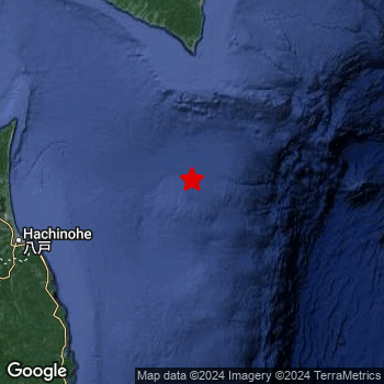 Map of area around epicenter. Click to open in Google Maps. |
| Magnitude: | MAG 5.4 Detected by 19 stations. Maximum Error Range ±0.071 . |
| Depth: | 26 km (16 mi) A quite shallow depth. |
| Max. Intensity: | III
Weak On the Modified Mercalli Scale. |
| Tsunami Risk: | Low tsunami risk Earthquakes under MAG-6.5 do not usually cause tsunami's. Always stay cautious - More info here. |
Minimal impact predicted
Based on scientific estimates by the US Geographic Survey (USGS), the risk of high fatalities for this earthquake is classified at level GREEN (low). They expect an 65% likelyhood of between 0 and 1 fatalities, and a 96% chance that the number of fatalities falls no higher than 10.
The USGS classifies the economic impact of this earthquake at level GREEN (low). They expect an 65% likelyhood of between 0 and 1 million US Dollars in economic damage and impact, and a 96% chance that the economic impact of this earthquake falls no higher than 10 million USD.
Roughly 2.1 million people exposed to shaking
The USGS has published a report estimating the number of people exposed to this earthquake. Acoording to their analysis, roughly 2.1 million have been exposed to shaking at an MMI level of II or higher.
An estimated 739,600 people were exposed to level III. At this level, weak shaking and probably no damage can be expected. The majority of people (roughly 1.4 million) live in an area exposed to level II, where very weak shaking and no damage is expected. All exposure to shaking was within the borders of Japan .
| People | MMI Level | Shaking | Damage |
|---|---|---|---|
| 0 | I |
Not noticable | None |
| 1,383,000 | II |
Very weak | None |
| 739,600 | III |
Weak | Probably none |
| 0 | IV |
Light | Likely none |
| 0 | V |
Moderate | Very light |
| 0 | VI |
Strong | Light |
| 0 | VII |
Very Strong | Moderate |
| 0 | VIII |
Severe | Moderate to heavy |
| 0 | IX |
Violent | Heavy |
| 0 | X |
Extreme | Very heavy |
Nearby towns and cities
This earthquake may have been felt in Japan . Located 151 kilometer (94 mi) east-northeast of the epicenter of this earthquake, Hachinohe (Aomori, Japan) is the nearest significant population center. The intensity of shaking and damage in Hachinohe is estimated to be around level III on the Modified Mercalli Intensity scale (weak shaking, probably no damage).
Multiple large cities are in proximity of today's earthquake. Sapporo is located 289 km to the north-northwest (intensity unknown, possibly low). Hachinohe is located 151 km to the west-southwest and experienced an intensity of III (weak shaking, probably no damage). Aomori is located 210 km to the west (intensity unknown, possibly low).
An overview of nearby towns and cities is available in the overview below. If places don't have intensity data available, it likely means the experienced impact in those places was fairly small.
Overview of nearby places
| Distance | Place | Intensity (MMI) |
|---|---|---|
| 151 km (94 mi) WSW from epicenter |
Hachinohe Aomori, Japan. |
III
Weak |
| 156 km (97 mi) W from epicenter |
Misawa Aomori, Japan. |
III
Weak |
| 174 km (108 mi) WNW from epicenter |
Mutsu Aomori, Japan. |
III
Weak |
| 175 km (109 mi) SW from epicenter |
Miyako Iwate, Japan. |
II
Weak |
| 177 km (110 mi) NNW from epicenter |
Shizunai-furukawachō Hokkaido, Japan. |
III
Weak |
| 191 km (119 mi) SW from epicenter |
Yamada Iwate, Japan. |
III
Weak |
| 210 km (130 mi) W from epicenter |
Aomori Aomori, Japan. |
|
| 212 km (132 mi) SSW from epicenter |
Kamaishi Iwate, Japan. |
II
Weak |
| 219 km (136 mi) SW from epicenter |
Morioka Iwate, Japan. |
II
Weak |
| 220 km (137 mi) WSW from epicenter |
Hanawa Akita, Japan. |
|
| 223 km (139 mi) W from epicenter |
Namioka Aomori, Japan. |
|
| 224 km (139 mi) W from epicenter |
Kuroishi Aomori, Japan. |
|
| 225 km (140 mi) SW from epicenter |
Tōno Iwate, Japan. |
II
Weak |
| 227 km (141 mi) N from epicenter |
Obihiro Hokkaido, Japan. |
|
| 231 km (144 mi) SW from epicenter |
Shizukuishi Iwate, Japan. |
II
Weak |
| 231 km (144 mi) WNW from epicenter |
Hakodate Hokkaido, Japan. |
|
| 234 km (145 mi) W from epicenter |
Goshogawara Aomori, Japan. |
|
| 234 km (145 mi) W from epicenter |
Hirosaki Aomori, Japan. |
|
| 235 km (146 mi) N from epicenter |
Otofuke Hokkaido, Japan. |
|
| 235 km (146 mi) WSW from epicenter |
Ōdate Akita, Japan. |
|
| 237 km (147 mi) NW from epicenter |
Tomakomai Hokkaido, Japan. |
II
Weak |
| 238 km (148 mi) SSW from epicenter |
Ōfunato Iwate, Japan. |
II
Weak |
| 240 km (149 mi) WNW from epicenter |
Kamiiso Hokkaido, Japan. |
|
| 240 km (149 mi) W from epicenter |
Shimokizukuri Aomori, Japan. |
|
| 240 km (149 mi) WNW from epicenter |
Honchō Hokkaido, Japan. |
|
| 243 km (151 mi) NW from epicenter |
Shiraoi Hokkaido, Japan. |
II
Weak |
| 244 km (152 mi) SW from epicenter |
Hanamaki Iwate, Japan. |
II
Weak |
| 245 km (152 mi) NW from epicenter |
Muroran Hokkaido, Japan. |
II
Weak |
| 252 km (157 mi) NNW from epicenter |
Chitose Hokkaido, Japan. |
|
| 252 km (157 mi) WSW from epicenter |
Takanosu Akita, Japan. |
|
| 252 km (157 mi) NNE from epicenter |
Kushiro Hokkaido, Japan. |
|
| 252 km (157 mi) SW from epicenter |
Kitakami Iwate, Japan. |
II
Weak |
| 259 km (161 mi) SW from epicenter |
Kanegasaki Iwate, Japan. |
II
Weak |
| 263 km (163 mi) SW from epicenter |
Mizusawa Iwate, Japan. |
II
Weak |
| 264 km (164 mi) NW from epicenter |
Date Hokkaido, Japan. |
|
| 271 km (168 mi) NNW from epicenter |
Kitahiroshima Hokkaido, Japan. |
|
| 280 km (174 mi) WSW from epicenter |
Noshiro Akita, Japan. |
|
| 282 km (175 mi) SW from epicenter |
Ōmagari Akita, Japan. |
|
| 282 km (175 mi) SW from epicenter |
Ichinoseki Iwate, Japan. |
|
| 284 km (176 mi) NNW from epicenter |
Shimo-furano Hokkaido, Japan. |
|
| 284 km (176 mi) NNW from epicenter |
Ebetsu Hokkaido, Japan. |
|
| 285 km (177 mi) NNW from epicenter |
Iwamizawa Hokkaido, Japan. |
|
| 286 km (178 mi) SW from epicenter |
Yokote Akita, Japan. |
|
| 289 km (180 mi) NNW from epicenter |
Sapporo Hokkaido, Japan. |
|
| 294 km (183 mi) WSW from epicenter |
Akita Akita, Japan. |
|
| 295 km (183 mi) NNW from epicenter |
Bibai Hokkaido, Japan. |
|
| 296 km (184 mi) NNW from epicenter |
Tōbetsu Hokkaido, Japan. |
|
| 297 km (185 mi) WSW from epicenter |
Tennō Akita, Japan. |
Earthquake Intensity Map
The graph below overlays a map of the region around the epicenter with earthquake intensity data provided by the US Geographic Survey. The highest intensity level detected for this earthquake is III.

Risk of aftershocks?
We have not yet detected any foreshocks or aftershocks (MAG-2.5 or higher) within 100km (62 mi) of this earthquake.
Aftershocks are usually at least 1 order of magnitude less strong than main shocks. The more time passes, the smaller the chance and likely strength of any potential aftershocks.
In only six percent of cases, significant earthquakes are followed by a larger main shock, making the current earthquake a foreshock. While the chance of this happening is not so large, it is adviced to maintain cautiousness in the hours and days following a major earthquake.
Read: How to Stay Safe during an Earthquake (cdc.gov).Earthquakes like this happen often in the region
Earthquakes of this strength are very common in the region. This is the strongest earthquake to hit since April 1st, 2024, when a 5.9 magnitude earthquake hit 153 km (95 mi) further west-southwest. An even stronger magnitude 6.8 earthquake struck on May 12th, 2015.
In total, 63 earthquakes with a magnitude of 5.4 or higher have been registered within 300km (186 mi) of this epicenter in the past 10 years. This comes down to an average of once every 2 months.
Low tsunami risk
Based on early data it appears this earthquake was not strong enough (lower than MAG-6.5) to be likely to cause destructive tsunami's. However this earthquake appeared to have hit at a shallow depth under sea, so stay cautious and monitor advice from local authorities.
Tsunami Risk Factors
| Factor | Under Sea? | MAG-6.5 or stronger? | Shallow depth? |
|---|---|---|---|
| Explanation | Almost all tsunami's are caused by earthquakes with their epicenter under sea or very near the sea. However stay cautious in coastal areas as earthquakes on land may cause landslides into sea, potentially still causing a local tsunami. | Under MAG 6.5: Very unlikely to cause a tsunami. MAG 6.5 to 7.5: Destructive tsunami's do occur, but are uncommon. Likely to observe small sea level changes. MAG 7.6+: Earthquakes with these magnitudes might produce destructive tsunami's. |
Most destructive tsunami's are caused by shallow earthquakes with a depth between 0 and 100km under the surface of the earth. Deeper tsunami's are unlikely to displace to ocean floor. |
| This Earthquake | This earthquake appears to have struck under the sea. | Not this earthquake. This earthquake had a magnitude of 5.4. Earthquakes of this strength are unlikely to trigger a tsunami. |
This earthquake occurred at a depth of of 26 km (16 mi). Earthquakes this shallow could trigger a tsunami. |
Sources
Last updated 01/05/24 02:28 (). As more information on this earthquake becomes available this article will be updated. This article is automatically composed based on data originating from multiple sources.
- US Geographic Society (USGS): Earthquake us7000mac0
- European-Mediterranean Seismological Centre (EMSC): Earthquake 20240406_0000001
- Geonames.org: World Cities Database
- Google Maps: Static API
- Earthquakelist.org: Historic Earthquakes Database
Share this article:
