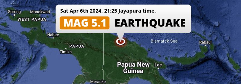
In the evening of Saturday April 6th, 2024, a significant M5.0 earthquake hit under land 97 kilometer from Wewak in Papua New Guinea. Another country near the epicenter is Indonesia.
Felt the earthquake? Share this article: 


Earthquake Summary
The earthquake struck on land in Papua New Guinea, 97 kilometer (60 mi) southwest of Wewak in East Sepik. The center of this earthquake had a quite shallow depth of 63 km. Shallow earthquakes usually have a larger impact than earthquakes deep in the earth.
| Date and Time: | Apr 6, 2024 22:25 (Port Moresby Time) - Apr 6, 2024 12:25 Universal Time. |
|---|---|
| Location: | 97 km SW of Wewak, East Sepik, Papua New Guinea. Coordinates 4°1'41"S 142°54'11"E. |
| Map: | 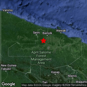 Map of area around epicenter. Click to open in Google Maps. |
| Magnitude: | MAG 5.0 Detected by 101 stations. Maximum Error Range ±0.056 . |
| Depth: | 63 km (39 mi) A quite shallow depth. |
| Tsunami Risk: | Tsunami very unlikely While this was a shallow earthquake, it appears to have occurred under land with a magnitude not strong enough to cause tsunami's. Always stay cautious - More info here. |
Nearby towns and cities
Papua New Guinea and Indonesia are both located within 300km distance of the epicenter of the earthquake.
The closest significant population center near the earthquake is Wewak in East Sepik, Papua New Guinea. Wewak is located 97 kilometer (60 mi) southwest of the epicenter.
An overview of nearby towns and cities is available in the overview below.
Overview of nearby places
| Distance | Place |
|---|---|
| 97 km (60 mi) NE from epicenter |
Wewak East Sepik, Papua New Guinea. |
| 250 km (155 mi) SSE from epicenter |
Mendi Southern Highlands, Papua New Guinea. |
| 251 km (156 mi) SE from epicenter |
Mount Hagen Western Highlands, Papua New Guinea. |
| 294 km (183 mi) NW from epicenter |
Jayapura Papua, Indonesia. |
| 298 km (185 mi) WNW from epicenter |
Abepura Papua, Indonesia. |
Shaking reported by 1 person
People that feel an earthquake may report their experience to the US Geographic Survey. Currently, 1 person has reported shaking in one place in Papua New Guinea.We keep updating this article as more ground reports become available. You may report that you felt this earthquake here.
Places with most reports:
- Mount Hagen, Western Highlands, Papua New Guinea: 1 person.
Aftershocks detected
Since this main shock, 1 smaller aftershock was detected. A 4.4 magnitude earthquake hit 2 days later 27 km (17 mi) east-southeast of this earthquake.
This main shock was prefaced by 1 smaller foreshock. Roughly 1 day before this earthquake, a foreshock measuring MAG-4.3 was detected nearby this earthquake.
Overview of foreshocks and aftershocks
| Classification | Magnitude | When | Where |
|---|---|---|---|
| Foreshock | M 4.3 |
1 day earlier Apr 5, 2024 16:16 (Port Moresby Time) | 45 km (28 mi) ESE from Main Shock. |
| Main Shock This Earthquake |
M 5.0 |
Apr 6, 2024 22:25 (Port Moresby Time) | - |
| Aftershock | M 4.4 |
2 days later Apr 9, 2024 01:34 (Port Moresby Time) | 27 km (17 mi) ESE from Main Shock. |
More earthquakes coming?
Aftershocks are usually at least 1 order of magnitude less strong than main shocks. The more time passes, the smaller the chance and likely strength of any potential aftershocks.
In only six percent of cases, significant earthquakes are followed by a larger main shock, making the current earthquake a foreshock. While the chance of this happening is not so large, it is adviced to maintain cautiousness in the hours and days following a major earthquake.
Read: How to Stay Safe during an Earthquake (cdc.gov).Earthquakes like this happen often in the region
Earthquakes of this strength are very common in the region. This is the strongest earthquake to hit since March 24th, 2024, when a 5.2 magnitude earthquake hit 26 km (16 mi) further east. An even stronger magnitude 7.5 earthquake struck on February 25th, 2018.
In total, 189 earthquakes with a magnitude of 5 or higher have been registered within 300km (186 mi) of this epicenter in the past 10 years. This comes down to an average of once every 19 days.
Tsunami very unlikely
While MAG-6.5+ earthquakes may cause tsunami's, it appears that the epicenter of this earthquake hit under land. In addition, the reported depth is deeper than 100km, making the risk of a tsunami even less likely. However always stay cautious and monitor advice from local authorities.
Tsunami Risk Factors
| Factor | Under Sea? | MAG-6.5 or stronger? | Shallow depth? |
|---|---|---|---|
| Explanation | Almost all tsunami's are caused by earthquakes with their epicenter under sea or very near the sea. However stay cautious in coastal areas as earthquakes on land may cause landslides into sea, potentially still causing a local tsunami. | Under MAG 6.5: Very unlikely to cause a tsunami. MAG 6.5 to 7.5: Destructive tsunami's do occur, but are uncommon. Likely to observe small sea level changes. MAG 7.6+: Earthquakes with these magnitudes might produce destructive tsunami's. |
Most destructive tsunami's are caused by shallow earthquakes with a depth between 0 and 100km under the surface of the earth. Deeper tsunami's are unlikely to displace to ocean floor. |
| This Earthquake | Not this earthquake. This earthquake appears to have struck on land far from any coast. |
Not this earthquake. This earthquake had a magnitude of 5. Earthquakes of this strength are unlikely to trigger a tsunami. |
This earthquake occurred at a depth of of 63 km (39 mi). Earthquakes this shallow could trigger a tsunami. |
Sources
Last updated 04/05/24 02:58 (). This article contains currently available information about the earthquake and is automatically composed. We continue to update this article up to a few days after the earthquake occurred.
- US Geographic Society (USGS): Earthquake us7000mag1
- European-Mediterranean Seismological Centre (EMSC): Earthquake 20240406_0000142
- Geonames.org: World Cities Database
- Google Maps: Static API
- Earthquakelist.org: Historic Earthquakes Database
Share this article:
