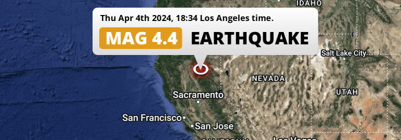
Under land 35 miles from Chico in The United States, a shallow Magnitude 4.4 earthquake occurred in the evening of Thursday April 4th, 2024. Around 4.2 million people have been exposed to shaking.
Felt the earthquake? Share this article: 


Earthquake Summary
The earthquake struck on land in The United States, 35 miles (57 km) north-east of Chico in California. The center of this earthquake had a very shallow depth of 5 km. Shallow earthquakes usually have a larger impact than earthquakes deep in the earth.
| Date and Time: | Apr 4, 2024 06:34PM (Los Angeles Time) - Apr 5, 2024 01:34 Universal Time. |
|---|---|
| Location: | 35 mi NE of Chico, California, The United States. Coordinates 40°2'24"N 121°18'2"W. |
| Map: | 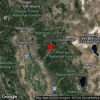 Map of area around epicenter. Click to open in Google Maps. |
| Magnitude: | MAG 4.4 Detected by 6 stations. Maximum Error Range ±0.3 . |
| Depth: | 5 mi (8 km) A very shallow depth. |
| Max. Intensity: | V
Moderate On the Modified Mercalli Scale. |
| Tsunami Risk: | Tsunami very unlikely While this was a shallow earthquake, it appears to have occurred under land with a magnitude not strong enough to cause tsunami's. Always stay cautious - More info here. |
Minimal impact predicted
Based on scientific estimates by the US Geographic Survey (USGS), the risk of high fatalities for this earthquake is classified at level GREEN (low). They expect an 65% likelyhood of between 0 and 1 fatalities, and a 96% chance that the number of fatalities falls no higher than 10.
The USGS classifies the economic impact of this earthquake at level GREEN (low). They expect an 65% likelyhood of between 0 and 1 million US Dollars in economic damage and impact, and a 96% chance that the economic impact of this earthquake falls no higher than 10 million USD.
Roughly 4.2 million people exposed to shaking
The USGS has published a report estimating the number of people exposed to this earthquake. Acoording to their analysis, roughly 4.2 million have been exposed to shaking at an MMI level of II or higher.
An estimated 22,160 people were exposed to level IV. At this level, light shaking and likely no damage can be expected. Intensity level II was experienced by the majority of people (around 3.4 million). In their region, very weak shaking and no damage can be expected.
| People | MMI Level | Shaking | Damage |
|---|---|---|---|
| 911,700 | I |
Not noticable | None |
| 3,423,000 | II |
Very weak | None |
| 775,900 | III |
Weak | Probably none |
| 22,160 | IV |
Light | Likely none |
| 0 | V |
Moderate | Very light |
| 0 | VI |
Strong | Light |
| 0 | VII |
Very Strong | Moderate |
| 0 | VIII |
Severe | Moderate to heavy |
| 0 | IX |
Violent | Heavy |
| 0 | X |
Extreme | Very heavy |
Nearby towns and cities
This earthquake may have been felt in The United States . Located 26 miles (42 km) north-east of the epicenter of this earthquake, Paradise (California, The United States) is the nearest significant population center. The intensity of shaking and damage in Paradise is estimated to be around level III on the Modified Mercalli Intensity scale (weak shaking, probably no damage).
Multiple major population centers exist within 300km of the earthquake that struck today. San Francisco is located 168 mi to the south-southwest (intensity unknown, possibly low). Sacramento is located 101 mi to the south and experienced an intensity of III (weak shaking, probably no damage). Chico is located 35 mi to the southwest and experienced an intensity of III (weak shaking, probably no damage).
The table below provides an overview of all places in proximity of today's earthquake. Where available, the estimated intensity on the Modified Mercalli Intensity Scale in each place is included. Places where this information is omitted likely experienced little impact.
Overview of nearby places
| Distance | Place | Intensity (MMI) |
|---|---|---|
| 26 mi (42 km) SW from epicenter |
Paradise California, The United States. |
III
Weak |
| 35 mi (57 km) SW from epicenter |
Chico California, The United States. |
III
Weak |
| 39 mi (62 km) SSW from epicenter |
Oroville California, The United States. |
III
Weak |
| 43 mi (69 km) NE from epicenter |
Susanville California, The United States. |
III
Weak |
| 65 mi (104 km) SSW from epicenter |
Yuba City California, The United States. |
III
Weak |
| 65 mi (104 km) S from epicenter |
Linda California, The United States. |
III
Weak |
| 66 mi (107 km) SSW from epicenter |
South Yuba City California, The United States. |
III
Weak |
| 69 mi (111 km) WNW from epicenter |
Redding California, The United States. |
II
Weak |
| 77 mi (124 km) SE from epicenter |
Truckee California, The United States. |
II
Weak |
| 80 mi (128 km) S from epicenter |
Lincoln California, The United States. |
II
Weak |
| 86 mi (139 km) ESE from epicenter |
Sun Valley Nevada, The United States. |
II
Weak |
| 86 mi (139 km) ESE from epicenter |
Reno Nevada, The United States. |
II
Weak |
| 86 mi (139 km) S from epicenter |
Rocklin California, The United States. |
II
Weak |
| 88 mi (142 km) S from epicenter |
Granite Bay California, The United States. |
II
Weak |
| 89 mi (143 km) S from epicenter |
Roseville California, The United States. |
II
Weak |
| 89 mi (144 km) ESE from epicenter |
Sparks Nevada, The United States. |
II
Weak |
| 92 mi (148 km) S from epicenter |
Citrus Heights California, The United States. |
II
Weak |
| 92 mi (148 km) S from epicenter |
Antelope California, The United States. |
II
Weak |
| 94 mi (151 km) S from epicenter |
Foothill Farms California, The United States. |
II
Weak |
| 94 mi (151 km) S from epicenter |
North Highlands California, The United States. |
II
Weak |
| 94 mi (152 km) S from epicenter |
Orangevale California, The United States. |
III
Weak |
| 94 mi (152 km) S from epicenter |
El Dorado Hills California, The United States. |
II
Weak |
| 94 mi (152 km) S from epicenter |
Folsom California, The United States. |
III
Weak |
| 96 mi (155 km) S from epicenter |
Fair Oaks California, The United States. |
II
Weak |
| 98 mi (157 km) SSW from epicenter |
Woodland California, The United States. |
III
Weak |
| 98 mi (158 km) S from epicenter |
Carmichael California, The United States. |
II
Weak |
| 99 mi (160 km) S from epicenter |
Arden-Arcade California, The United States. |
II
Weak |
| 100 mi (161 km) S from epicenter |
Rancho Cordova California, The United States. |
II
Weak |
| 101 mi (163 km) S from epicenter |
West Sacramento California, The United States. |
III
Weak |
| 101 mi (163 km) S from epicenter |
Sacramento California, The United States. |
III
Weak |
| 102 mi (164 km) SE from epicenter |
Carson City Nevada, The United States. |
II
Weak |
| 103 mi (166 km) S from epicenter |
Rosemont California, The United States. |
II
Weak |
| 106 mi (171 km) SSW from epicenter |
Davis California, The United States. |
II
Weak |
| 107 mi (172 km) S from epicenter |
Florin California, The United States. |
II
Weak |
| 109 mi (175 km) S from epicenter |
Vineyard California, The United States. |
II
Weak |
| 112 mi (180 km) S from epicenter |
Laguna California, The United States. |
II
Weak |
| 112 mi (181 km) S from epicenter |
Elk Grove California, The United States. |
II
Weak |
| 122 mi (196 km) SSW from epicenter |
Vacaville California, The United States. |
II
Weak |
| 130 mi (209 km) SSW from epicenter |
Fairfield California, The United States. |
I
Not felt |
| 132 mi (212 km) SSW from epicenter |
Napa California, The United States. |
I
Not felt |
| 134 mi (216 km) SW from epicenter |
Santa Rosa California, The United States. |
I
Not felt |
| 143 mi (230 km) S from epicenter |
Antioch California, The United States. |
|
| 144 mi (231 km) SSW from epicenter |
Vallejo California, The United States. |
|
| 144 mi (232 km) S from epicenter |
Stockton California, The United States. |
|
| 148 mi (238 km) SSW from epicenter |
Concord California, The United States. |
|
| 158 mi (255 km) SSW from epicenter |
Berkeley California, The United States. |
|
| 163 mi (262 km) SSW from epicenter |
Oakland California, The United States. |
|
| 167 mi (268 km) S from epicenter |
Modesto California, The United States. |
|
| 168 mi (270 km) SSW from epicenter |
San Francisco California, The United States. |
|
| 169 mi (272 km) SSW from epicenter |
Hayward California, The United States. |
|
| 176 mi (283 km) SSW from epicenter |
Fremont California, The United States. |
|
| 178 mi (286 km) NNW from epicenter |
Medford Oregon, The United States. |
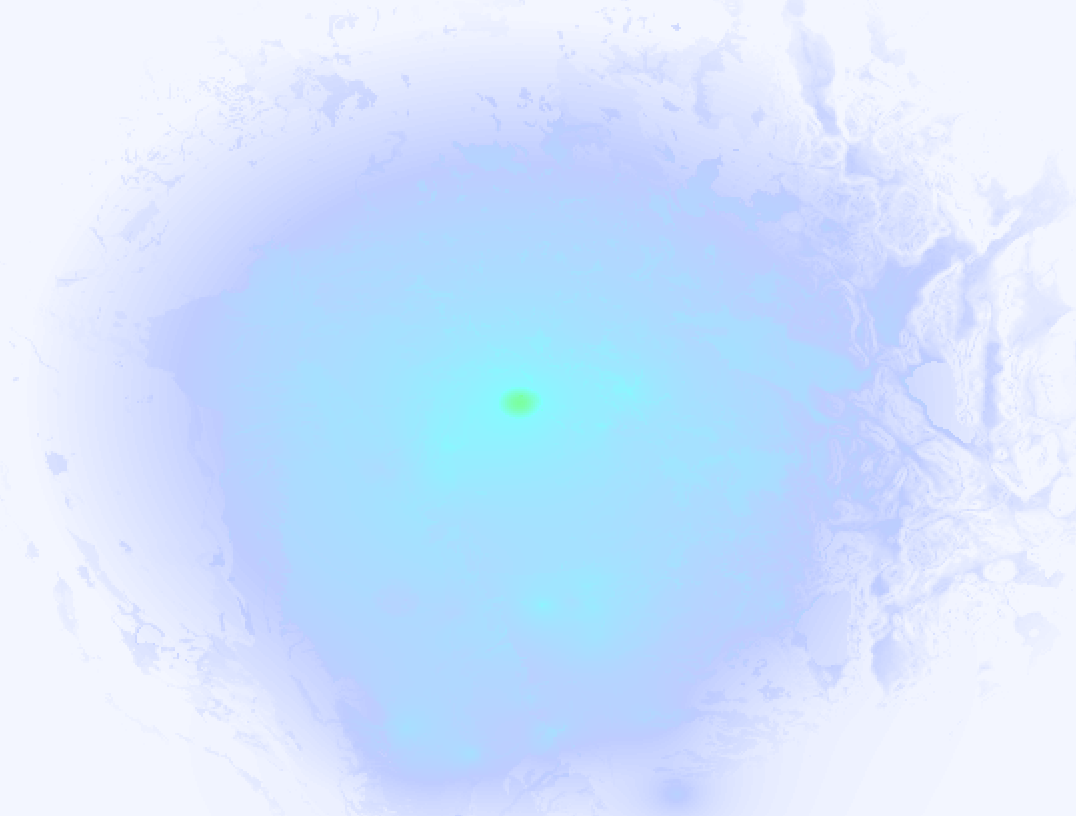
Earthquake Intensity Map
The graph below overlays a map of the region around the epicenter with earthquake intensity data provided by the US Geographic Survey. The highest intensity level detected for this earthquake is V.
4 Aftershocks detected
This main shock was followed by 4 smaller aftershocks. Just 9 hrs after this main shock, an earthquake measuring MAG-2.9 was detected 0.1 mi (0.1 km) east-northeast of this earthquake.
Before this earthquake struck, 1 smaller foreshock occurred. Nearby this earthquake a foreshock struck 25 sec earlier. It measured a magnitude of 4.1
Overview of foreshocks and aftershocks
| Classification | Magnitude | When | Where |
|---|---|---|---|
| Foreshock | M 4.1 |
25 sec earlier Apr 4, 2024 06:34PM (Los Angeles Time) | 0.9 mi (1.5 km) WSW from Main Shock. |
| Main Shock This Earthquake |
M 4.4 |
Apr 4, 2024 06:34PM (Los Angeles Time) | - |
| Aftershock | M 2.7 |
29 mins later Apr 4, 2024 07:03PM (Los Angeles Time) | 0.2 mi (0.4 km) SE from Main Shock. |
| Aftershock | M 2.6 |
9 hrs later Apr 5, 2024 03:26AM (Los Angeles Time) | 0.2 mi (0.4 km) ENE from Main Shock. |
| Aftershock | M 2.9 |
9 hrs later Apr 5, 2024 03:46AM (Los Angeles Time) | 0.1 mi (0.1 km) ENE from Main Shock. |
| Aftershock | M 2.5 |
3 days later Apr 7, 2024 06:26PM (Los Angeles Time) | 0.1 mi (0.2 km) SE from Main Shock. |
More earthquakes coming?
The risk of aftershocks decreases rapidly over time. Usually, aftershocks are at least one order of magnitude lower than a main shock.
In only six percent of cases, significant earthquakes are followed by a larger main shock, making the current earthquake a foreshock. While the chance of this happening is not so large, it is adviced to maintain cautiousness in the hours and days following a major earthquake.
Read: How to Stay Safe during an Earthquake (cdc.gov).Earthquakes like this happen often in the region
Earthquakes of this strength are very common in the region. This is the strongest earthquake to hit since October 16th, 2023, when a 4.8 magnitude earthquake hit 147 mi (236 km) further west. An even stronger magnitude 6.4 earthquake struck on December 20th, 2022.
In total, 65 earthquakes with a magnitude of 4.4 or higher have been registered within 300km (186 mi) of this epicenter in the past 10 years. This comes down to an average of once every 2 months.
Tsunami very unlikely
While MAG-6.5+ earthquakes may cause tsunami's, it appears that the epicenter of this earthquake hit under land. In addition, the reported depth is deeper than 100km, making the risk of a tsunami even less likely. However always stay cautious and monitor advice from local authorities.
Tsunami Risk Factors
| Factor | Under Sea? | MAG-6.5 or stronger? | Shallow depth? |
|---|---|---|---|
| Explanation | Almost all tsunami's are caused by earthquakes with their epicenter under sea or very near the sea. However stay cautious in coastal areas as earthquakes on land may cause landslides into sea, potentially still causing a local tsunami. | Under MAG 6.5: Very unlikely to cause a tsunami. MAG 6.5 to 7.5: Destructive tsunami's do occur, but are uncommon. Likely to observe small sea level changes. MAG 7.6+: Earthquakes with these magnitudes might produce destructive tsunami's. |
Most destructive tsunami's are caused by shallow earthquakes with a depth between 0 and 100km under the surface of the earth. Deeper tsunami's are unlikely to displace to ocean floor. |
| This Earthquake | Not this earthquake. This earthquake appears to have struck on land far from any coast. |
Not this earthquake. This earthquake had a magnitude of 4.4. Earthquakes of this strength are unlikely to trigger a tsunami. |
This earthquake occurred at a depth of of 5 mi (8 km). Earthquakes this shallow could trigger a tsunami. |
Sources
Last updated 04/05/24 02:18 (). This article is automatically generated based on available data. We keep checking multiple sources for additional information. This article gets updated as new details on this earthquake become available.
- US Geographic Society (USGS): Earthquake nc71133194
- European-Mediterranean Seismological Centre (EMSC): Earthquake 20240405_0000073
- Geonames.org: World Cities Database
- Google Maps: Static API
- Earthquakelist.org: Historic Earthquakes Database
Share this article:
