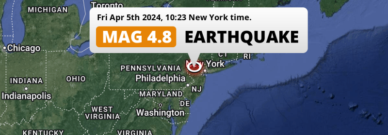
Under land 40 miles from New York City in The United States, an unusually powerful M4.8 earthquake occurred in the morning of Friday April 5th, 2024. The earthquake struck near a very densely populated region. The USGS has indicated there is a potential risk at tsunami's following this earthquake.
Felt the earthquake? Share this article: 


Earthquake Summary
The earthquake struck on land in The United States, 40 miles (64 km) west of New York City in New York. The center of this earthquake had a very shallow depth of 2 km. Shallow earthquakes usually have a larger impact than earthquakes deep in the earth.
| Date and Time: | Apr 5, 2024 10:23AM (New York Time) - Apr 5, 2024 14:23 Universal Time. |
|---|---|
| Location: | 40 mi west of New York City, New York, The United States. Coordinates 40°41'47"N 74°45'35"W. |
| Map: | 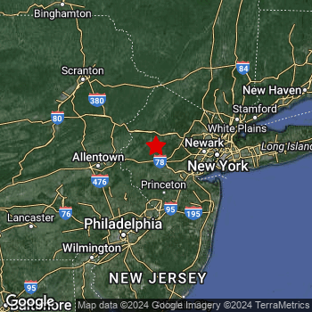 Map of area around epicenter. Click to open in Google Maps. |
| Magnitude: | MAG 4.8 Detected by 20 stations. Maximum Error Range ±0.027 . |
| Depth: | 2 mi (3 km) A very shallow depth. |
| Max. Intensity: | VII
Very Strong On the Modified Mercalli Scale. |
| Tsunami Risk: | Potential tsunami risk The USGS has indicated there is a potential risk at tsunami's following this earthquake. Always stay cautious - More info here. |
Potential tsunami risk
There is a potential tsunami risk in the aftermath of this earthquake, immediately evacuate to higher grounds away from coastal areas and monitor advice from local authorities. The US Geographic Survey organization has indicated a potential risk for tsunami's following this earthquake.
Tsunami Risk Factors
| Factor | Under Sea? | MAG-6.5 or stronger? | Shallow depth? |
|---|---|---|---|
| Explanation | Almost all tsunami's are caused by earthquakes with their epicenter under sea or very near the sea. However stay cautious in coastal areas as earthquakes on land may cause landslides into sea, potentially still causing a local tsunami. | Under MAG 6.5: Very unlikely to cause a tsunami. MAG 6.5 to 7.5: Destructive tsunami's do occur, but are uncommon. Likely to observe small sea level changes. MAG 7.6+: Earthquakes with these magnitudes might produce destructive tsunami's. |
Most destructive tsunami's are caused by shallow earthquakes with a depth between 0 and 100km under the surface of the earth. Deeper tsunami's are unlikely to displace to ocean floor. |
| This Earthquake | Not this earthquake. This earthquake appears to have struck on land far from any coast. |
Not this earthquake. This earthquake had a magnitude of 4.8. Earthquakes of this strength are unlikely to trigger a tsunami. |
This earthquake occurred at a depth of of 2 mi (3 km). Earthquakes this shallow could trigger a tsunami. |
Minimal impact predicted
Based on scientific estimates by the US Geographic Survey (USGS), the risk of high fatalities for this earthquake is classified at level GREEN (low). They expect an 69% likelyhood of between 0 and 1 fatalities, and a 98% chance that the number of fatalities falls no higher than 10.
The USGS classifies the economic impact of this earthquake at level GREEN (low). They expect an 98% likelyhood of between 0 and 1 million US Dollars in economic damage and impact.
Roughly 43 million people exposed to shaking
An estimated 43 million have been exposed to shaking (An MMI or Modified Mercalli Intensity level II or higher) as a result of this earthquake according scientific estimates published by the USGS.
An estimated 10,560 people were exposed to level VI. At this level, strong shaking and probably light damage can be expected. Intensity level III was experienced by the majority of people (around 22 million). In their region, weak shaking and probably no damage can be expected.
| People | MMI Level | Shaking | Damage |
|---|---|---|---|
| 0 | I |
Not noticable | None |
| 3,172,000 | II |
Very weak | None |
| 22,120,000 | III |
Weak | Probably none |
| 17,260,000 | IV |
Light | Likely none |
| 210,700 | V |
Moderate | Very light |
| 10,560 | VI |
Strong | Light |
| 0 | VII |
Very Strong | Moderate |
| 0 | VIII |
Severe | Moderate to heavy |
| 0 | IX |
Violent | Heavy |
| 0 | X |
Extreme | Very heavy |
Nearby towns and cities
This earthquake may have been felt in The United States . Located 9 miles (14 km) northwest of the epicenter of this earthquake, Bridgewater (New Jersey, The United States) is the nearest significant population center. The intensity of shaking and damage in Bridgewater is estimated to be around level V on the Modified Mercalli Intensity scale (moderate shaking, very light damage).
Multiple major population centers exist within 300km of the earthquake that struck today. New York City is located 40 mi to the east and experienced an intensity of III (weak shaking, probably no damage). Brooklyn is located 43 mi to the east and experienced an intensity of IV (light shaking, likely no damage). Queens is located 48 mi to the east and experienced an intensity of IV (light shaking, likely no damage).
A complete list of nearby places is included below. Estimated intensity data (MMI) sourced from a shake-map published by the US Geographic Survey is shown where available (cities without data probably experienced little impact).
Overview of nearby places
| Distance | Place | Intensity (MMI) |
|---|---|---|
| 9 mi (14 km) SE from epicenter |
Bridgewater New Jersey, The United States. |
V
Moderate |
| 11 mi (18 km) E from epicenter |
Basking Ridge New Jersey, The United States. |
IV
Light |
| 14 mi (23 km) ESE from epicenter |
Warren Township New Jersey, The United States. |
IV
Light |
| 14 mi (23 km) NE from epicenter |
Randolph New Jersey, The United States. |
IV
Light |
| 16 mi (26 km) ENE from epicenter |
Morristown New Jersey, The United States. |
IV
Light |
| 17 mi (27 km) NE from epicenter |
Dover New Jersey, The United States. |
IV
Light |
| 17 mi (27 km) SSE from epicenter |
Hillsborough New Jersey, The United States. |
IV
Light |
| 18 mi (29 km) ESE from epicenter |
North Plainfield New Jersey, The United States. |
IV
Light |
| 19 mi (31 km) ESE from epicenter |
Plainfield New Jersey, The United States. |
IV
Light |
| 20 mi (32 km) ESE from epicenter |
South Plainfield New Jersey, The United States. |
IV
Light |
| 20 mi (32 km) E from epicenter |
Scotch Plains New Jersey, The United States. |
IV
Light |
| 21 mi (33 km) ENE from epicenter |
Parsippany New Jersey, The United States. |
IV
Light |
| 22 mi (35 km) E from epicenter |
Westfield New Jersey, The United States. |
IV
Light |
| 22 mi (35 km) ESE from epicenter |
Edison New Jersey, The United States. |
IV
Light |
| 22 mi (35 km) SE from epicenter |
New Brunswick New Jersey, The United States. |
IV
Light |
| 24 mi (38 km) SE from epicenter |
Piscataway New Jersey, The United States. |
IV
Light |
| 26 mi (42 km) SE from epicenter |
East Brunswick New Jersey, The United States. |
IV
Light |
| 26 mi (42 km) E from epicenter |
Union New Jersey, The United States. |
IV
Light |
| 27 mi (43 km) SE from epicenter |
Sayreville New Jersey, The United States. |
IV
Light |
| 27 mi (44 km) E from epicenter |
Irvington New Jersey, The United States. |
IV
Light |
| 28 mi (45 km) ENE from epicenter |
West Orange New Jersey, The United States. |
IV
Light |
| 29 mi (46 km) E from epicenter |
Elizabeth New Jersey, The United States. |
IV
Light |
| 29 mi (47 km) ESE from epicenter |
Perth Amboy New Jersey, The United States. |
IV
Light |
| 29 mi (47 km) E from epicenter |
East Orange New Jersey, The United States. |
IV
Light |
| 30 mi (48 km) ENE from epicenter |
Wayne New Jersey, The United States. |
IV
Light |
| 31 mi (50 km) E from epicenter |
Newark New Jersey, The United States. |
IV
Light |
| 32 mi (52 km) W from epicenter |
Bethlehem Pennsylvania, The United States. |
III
Weak |
| 33 mi (53 km) ENE from epicenter |
Clifton New Jersey, The United States. |
IV
Light |
| 33 mi (53 km) S from epicenter |
Trenton New Jersey, The United States. |
IV
Light |
| 34 mi (54 km) ESE from epicenter |
Staten Island New York, The United States. |
IV
Light |
| 34 mi (55 km) ENE from epicenter |
Paterson New Jersey, The United States. |
IV
Light |
| 36 mi (58 km) E from epicenter |
Jersey City New Jersey, The United States. |
IV
Light |
| 39 mi (62 km) W from epicenter |
Allentown Pennsylvania, The United States. |
III
Weak |
| 39 mi (63 km) E from epicenter |
Sunset Park New York, The United States. |
IV
Light |
| 40 mi (64 km) E from epicenter |
New York City New York, The United States. |
III
Weak |
| 40 mi (65 km) E from epicenter |
Borough Park New York, The United States. |
IV
Light |
| 42 mi (68 km) E from epicenter |
Gravesend New York, The United States. |
IV
Light |
| 42 mi (68 km) E from epicenter |
Manhattan New York, The United States. |
III
Weak |
| 43 mi (69 km) E from epicenter |
Brooklyn New York, The United States. |
IV
Light |
| 43 mi (70 km) E from epicenter |
Harlem New York, The United States. |
IV
Light |
| 43 mi (70 km) E from epicenter |
East Harlem New York, The United States. |
IV
Light |
| 43 mi (70 km) E from epicenter |
Sheepshead Bay New York, The United States. |
IV
Light |
| 43 mi (70 km) E from epicenter |
East Flatbush New York, The United States. |
IV
Light |
| 43 mi (70 km) E from epicenter |
Astoria New York, The United States. |
IV
Light |
| 44 mi (71 km) ENE from epicenter |
Washington Heights New York, The United States. |
IV
Light |
| 46 mi (74 km) E from epicenter |
East New York New York, The United States. |
IV
Light |
| 48 mi (77 km) ENE from epicenter |
Yonkers New York, The United States. |
IV
Light |
| 48 mi (77 km) ENE from epicenter |
The Bronx New York, The United States. |
IV
Light |
| 48 mi (78 km) E from epicenter |
Queens New York, The United States. |
IV
Light |
| 50 mi (80 km) E from epicenter |
Jamaica New York, The United States. |
IV
Light |
| 56 mi (90 km) SSW from epicenter |
Philadelphia Pennsylvania, The United States. |
III
Weak |
| 68 mi (110 km) ENE from epicenter |
Stamford Connecticut, The United States. |
III
Weak |
| 78 mi (125 km) SSW from epicenter |
Wilmington Delaware, The United States. |
III
Weak |
| 138 mi (222 km) SW from epicenter |
Baltimore Maryland, The United States. |
III
Weak |
| 149 mi (239 km) NE from epicenter |
Springfield Massachusetts, The United States. |
III
Weak |
| 173 mi (279 km) SW from epicenter |
Washington Washington, D.C., The United States. |
II
Weak |
| 175 mi (281 km) ENE from epicenter |
Coventry Rhode Island, The United States. |
|
| 176 mi (284 km) SW from epicenter |
Arlington Virginia, The United States. |
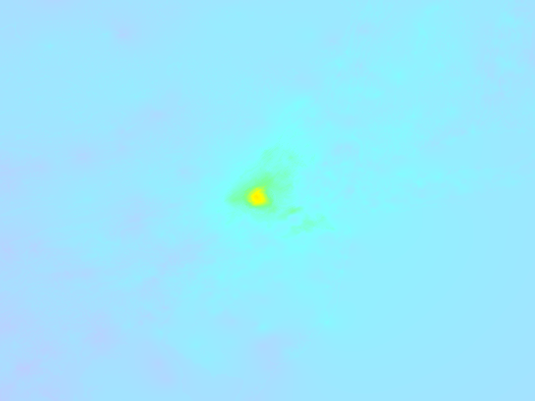
Earthquake Intensity Map
The graph below overlays a map of the region around the epicenter with earthquake intensity data provided by the US Geographic Survey. The highest intensity level detected for this earthquake is VI.
Shaking reported by 168 people in 4 countries
People that feel an earthquake may report their experience to the US Geographic Survey. Currently, 168 people have reported shaking in 60 places in 4 countries (Bahamas, Bermuda, Canada, Jamaica).We keep updating this article as more ground reports become available. You may report that you felt this earthquake here.
Places with most reports:
- Montreal, Québec, Canada: 19 people.
- Chatham-Douglastown, New Brunswick, Canada: 17 people.
- Beloeil, Québec, Canada: 14 people.
- Ottawa, Ontario, Canada: 13 people.
- Hamilton, Ontario, Canada: 10 people.
- Toronto, Ontario, Canada: 7 people.
- Kanata, Ontario, Canada: 6 people.
- Oka-Kanesatake, Québec, Canada: 6 people.
- Saint Catharines-Niagara, Ontario, Canada: 5 people.
- Fredericton, New Brunswick, Canada: 4 people.
2 Aftershocks detected
After this earthquake struck, 2 smaller aftershocks occurred. At a distance of 0.8 mi (1.3 km) east-southeast of this earthquake, an aftershock struck 8 hrs later. It measured a magnitude of 3.7
Overview of foreshocks and aftershocks
| Classification | Magnitude | When | Where |
|---|---|---|---|
| Main Shock This Earthquake |
M 4.8 |
Apr 5, 2024 10:23AM (New York Time) | - |
| Aftershock | M 2.6 |
7 mins later Apr 5, 2024 10:29AM (New York Time) | 0.6 mi (0.9 km) SW from Main Shock. |
| Aftershock | M 3.7 |
8 hrs later Apr 5, 2024 05:59PM (New York Time) | 0.8 mi (1.3 km) ESE from Main Shock. |
More earthquakes coming?
Earthquakes can create aftershocks. These are generally at least 1 magnitude lower than any main shock, and as time passes the chance and strength of aftershocks decreases.
In only six percent of cases, significant earthquakes are followed by a larger main shock, making the current earthquake a foreshock. While the chance of this happening is not so large, it is adviced to maintain cautiousness in the hours and days following a major earthquake.
Read: How to Stay Safe during an Earthquake (cdc.gov).This is an unusually powerful earthquake
No earthquake of this strength has struck this region for a long time. Our data goes back 10 years, and no earthquakes measuring a magnitude of 4.8 or higher have been detected within 300 km (186 mi) of this epicenter.
Sources
Last updated 04/05/24 01:18 (). This article contains currently available information about the earthquake and is automatically composed. We continue to update this article up to a few days after the earthquake occurred.
- US Geographic Society (USGS): Earthquake us7000ma74
- European-Mediterranean Seismological Centre (EMSC): Earthquake 20240405_0000185
- Geonames.org: World Cities Database
- Google Maps: Static API
- Earthquakelist.org: Historic Earthquakes Database
Share this article:
