1 miles from India, a shallow and significant MAG-5.0 earthquake occurred in the evening of Thursday April 4th, 2024. Another country near the epicenter is Pakistan.
Felt the earthquake? Share this article: 


Earthquake Summary
This earthquake struck 1 miles (1 km) from India The center of this earthquake had a very shallow depth of 10 km. Shallow earthquakes usually have a larger impact than earthquakes deep in the earth.
| Date and Time: | Apr 4, 2024 21:34 (Kolkata Time) - Apr 4, 2024 16:04 Universal Time. |
|---|---|
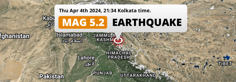
| Location: | 37 km SSW of Padam, Ladakh, India. Coordinates 33°8'33"N 76°47'48"E. |
| Map: |  Map of area around epicenter. Click to open in Google Maps. |
| Magnitude: | MAG 5.0 Detected by 18 stations. Maximum Error Range ±0.073 . |
| Depth: | 10 km (6 mi) A very shallow depth. |
| Tsunami Risk: | Low tsunami risk Earthquakes under MAG-6.5 do not usually cause tsunami's. Always stay cautious - More info here. |
Nearby towns and cities
This earthquake struck within proximity of multiple countries. India and Pakistan are both within 300km distance of its epicenter.
The closest significant population center near the earthquake is Padam in Ladakh, India. Padam is located 37 kilometer (23 mi) south-southwest of the epicenter.
Major cities near this earthquake: Lahore is located 290 km to the southwest. Ludhiāna is located 263 km to the south-southwest. Gujranwala is located 268 km to the west-southwest.
An overview of nearby towns and cities is available in the overview below.
Overview of nearby places
| Distance | Place |
|---|---|
| 37 km (23 mi) NNE from epicenter |
Padam Ladakh, India. |
| 90 km (56 mi) SW from epicenter |
Chamba Himachal Pradesh, India. |
| 98 km (61 mi) W from epicenter |
Kishtwār Jammu and Kashmir, India. |
| 112 km (70 mi) SSW from epicenter |
Dharamsala Himachal Pradesh, India. |
| 116 km (72 mi) W from epicenter |
Doda Jammu and Kashmir, India. |
| 135 km (84 mi) SSE from epicenter |
Kulu Himachal Pradesh, India. |
| 135 km (84 mi) NNE from epicenter |
Leh Ladakh, India. |
| 144 km (89 mi) SW from epicenter |
Pathānkot Punjab, India. |
| 147 km (91 mi) SW from epicenter |
Kathua Jammu and Kashmir, India. |
| 157 km (98 mi) W from epicenter |
Udhampur Jammu and Kashmir, India. |
| 159 km (99 mi) SSW from epicenter |
Talwāra Punjab, India. |
| 160 km (99 mi) S from epicenter |
Mandi Himachal Pradesh, India. |
| 164 km (102 mi) S from epicenter |
Hamīrpur Himachal Pradesh, India. |
| 166 km (103 mi) WNW from epicenter |
Anantnag Jammu and Kashmir, India. |
| 167 km (104 mi) SW from epicenter |
Dīnānagar Punjab, India. |
| 169 km (105 mi) WSW from epicenter |
Sāmba Jammu and Kashmir, India. |
| 172 km (107 mi) SW from epicenter |
Mukeriān Punjab, India. |
| 173 km (107 mi) WNW from epicenter |
Bijbehara Jammu and Kashmir, India. |
| 179 km (111 mi) S from epicenter |
Sundarnagar Himachal Pradesh, India. |
| 182 km (113 mi) WSW from epicenter |
Shakargarh Punjab, Pakistan. |
| 186 km (116 mi) WSW from epicenter |
Jammu Jammu and Kashmir, India. |
| 194 km (121 mi) SW from epicenter |
Fazilpur Punjab, Pakistan. |
| 197 km (122 mi) SSW from epicenter |
Hoshiārpur Punjab, India. |
| 199 km (124 mi) S from epicenter |
Nangal Punjab, India. |
| 211 km (131 mi) SW from epicenter |
Batāla Punjab, India. |
| 212 km (132 mi) WNW from epicenter |
Srinagar Jammu and Kashmir, India. |
| 214 km (133 mi) WSW from epicenter |
Narowal Punjab, Pakistan. |
| 220 km (137 mi) WNW from epicenter |
Soyībug Jammu and Kashmir, India. |
| 224 km (139 mi) WSW from epicenter |
Sialkot Punjab, Pakistan. |
| 229 km (142 mi) S from epicenter |
Shimla Himachal Pradesh, India. |
| 232 km (144 mi) SSW from epicenter |
Jalandhar Punjab, India. |
| 234 km (145 mi) SSW from epicenter |
Phagwāra Punjab, India. |
| 237 km (147 mi) SW from epicenter |
Kapūrthala Punjab, India. |
| 246 km (153 mi) WSW from epicenter |
Daska Kalan Punjab, Pakistan. |
| 247 km (153 mi) SW from epicenter |
Amritsar Punjab, India. |
| 248 km (154 mi) WSW from epicenter |
Jalalpur Jattan Punjab, Pakistan. |
| 254 km (158 mi) W from epicenter |
Bhimber Azad Kashmir, Pakistan. |
| 262 km (163 mi) WSW from epicenter |
Gujrat Punjab, Pakistan. |
| 262 km (163 mi) WSW from epicenter |
Wazirabad Punjab, Pakistan. |
| 263 km (163 mi) SSW from epicenter |
Ludhiāna Punjab, India. |
| 268 km (167 mi) S from epicenter |
Chandīgarh Chandigarh, India. |
| 268 km (167 mi) WSW from epicenter |
Gujranwala Punjab, Pakistan. |
| 272 km (169 mi) S from epicenter |
Panchkula Haryana, India. |
| 272 km (169 mi) W from epicenter |
Kotli Azad Kashmir, Pakistan. |
| 274 km (170 mi) S from epicenter |
Mohali Punjab, India. |
| 274 km (170 mi) WSW from epicenter |
Kamoke Punjab, Pakistan. |
| 276 km (171 mi) S from epicenter |
Khanna Punjab, India. |
| 281 km (175 mi) WSW from epicenter |
Muridke Punjab, Pakistan. |
| 283 km (176 mi) W from epicenter |
New Mirpur Azad Kashmir, Pakistan. |
| 287 km (178 mi) W from epicenter |
Jhelum Punjab, Pakistan. |
| 290 km (180 mi) SW from epicenter |
Lahore Punjab, Pakistan. |
Shaking reported by 19 people
People that feel an earthquake may report their experience to the US Geographic Survey. Currently, 19 people have reported shaking in 12 places, all within India.We keep updating this article as more ground reports become available. You may report that you felt this earthquake here.
Places with most reports:
- Manali, Himachal Pradesh, India: 5 people.
- Dharamshala, Himachal Pradesh, India: 4 people.
- Chamba, Himachal Pradesh, India: 1 person.
- Hamīrpur, Himachal Pradesh, India: 1 person.
- Jogindarnagar, Himachal Pradesh, India: 1 person.
- Anantnag, Jammu and Kashmir, India: 1 person.
- Banihal, Jammu and Kashmir, India: 1 person.
- Leh, Jammu and Kashmir, India: 1 person.
- Maisūru, Karnataka, India: 1 person.
- Adampur, Punjab, India: 1 person.
10 Aftershocks detected
Since this main shock, 10 smaller aftershocks were detected. Just 2 days after this main shock, an earthquake measuring MAG-4.3 was detected 7 km (4 mi) southwest of this earthquake.
In the days before this main shock, 1 smaller foreshock was detected. Roughly 3 days before this earthquake, a foreshock measuring MAG-3.5 was detected nearby this earthquake.
Overview of foreshocks and aftershocks
| Classification | Magnitude | When | Where |
|---|---|---|---|
| Foreshock | M 3.5 |
3 days earlier Apr 1, 2024 22:37 (Kolkata Time) | 49 km (31 mi) SSW from Main Shock. |
| Main Shock This Earthquake |
M 5.0 |
Apr 4, 2024 21:34 (Kolkata Time) | - |
| Aftershock | M 3.2 |
2 hrs later Apr 4, 2024 23:08 (Kolkata Time) | 28 km (18 mi) NNW from Main Shock. |
| Aftershock | M 2.9 |
4 hrs later Apr 5, 2024 01:24 (Kolkata Time) | 21 km (13 mi) NNW from Main Shock. |
| Aftershock | M 3.2 |
5 hrs later Apr 5, 2024 02:09 (Kolkata Time) | 27 km (17 mi) NNW from Main Shock. |
| Aftershock | M 2.9 |
9 hrs later Apr 5, 2024 06:56 (Kolkata Time) | 23 km (14 mi) NW from Main Shock. |
| Aftershock | M 3.8 |
20 hrs later Apr 5, 2024 17:20 (Kolkata Time) | 27 km (17 mi) NNW from Main Shock. |
| Aftershock | M 3.2 |
1 day later Apr 5, 2024 23:01 (Kolkata Time) | 27 km (17 mi) NW from Main Shock. |
| Aftershock | M 3.5 |
2 days later Apr 6, 2024 10:17 (Kolkata Time) | 24 km (15 mi) NNW from Main Shock. |
| Aftershock | M 4.3 |
2 days later Apr 6, 2024 14:53 (Kolkata Time) | 7 km (4 mi) SW from Main Shock. |
| Aftershock | M 3.4 |
2 days later Apr 6, 2024 22:55 (Kolkata Time) | 17 km (10 mi) N from Main Shock. |
| Aftershock | M 3.5 |
2 days later Apr 7, 2024 02:47 (Kolkata Time) | 25 km (16 mi) NNW from Main Shock. |
More earthquakes coming?
Earthquakes can create aftershocks. These are generally at least 1 magnitude lower than any main shock, and as time passes the chance and strength of aftershocks decreases.
In only six percent of cases, significant earthquakes are followed by a larger main shock, making the current earthquake a foreshock. While the chance of this happening is not so large, it is adviced to maintain cautiousness in the hours and days following a major earthquake.
Read: How to Stay Safe during an Earthquake (cdc.gov).Earthquakes like this are common in the region
Earthquakes of this strength occur quite regularly in the region. This is the strongest earthquake to hit since December 18th, 2023, when a 5.1 magnitude earthquake hit 6 km (4 mi) further north-east. An even stronger magnitude 5.4 earthquake struck on September 24th, 2019.
In total, 11 earthquakes with a magnitude of 5 or higher have been registered within 300km (186 mi) of this epicenter in the past 10 years. This comes down to an average of once every year.
Low tsunami risk
Based on early data it appears this earthquake was not strong enough (lower than MAG-6.5) to be likely to cause destructive tsunami's. However this earthquake appeared to have hit at a shallow depth under sea, so stay cautious and monitor advice from local authorities.
Tsunami Risk Factors
| Factor | Under Sea? | MAG-6.5 or stronger? | Shallow depth? |
|---|---|---|---|
| Explanation | Almost all tsunami's are caused by earthquakes with their epicenter under sea or very near the sea. However stay cautious in coastal areas as earthquakes on land may cause landslides into sea, potentially still causing a local tsunami. | Under MAG 6.5: Very unlikely to cause a tsunami. MAG 6.5 to 7.5: Destructive tsunami's do occur, but are uncommon. Likely to observe small sea level changes. MAG 7.6+: Earthquakes with these magnitudes might produce destructive tsunami's. |
Most destructive tsunami's are caused by shallow earthquakes with a depth between 0 and 100km under the surface of the earth. Deeper tsunami's are unlikely to displace to ocean floor. |
| This Earthquake | This earthquake appears to have struck under the sea. | Not this earthquake. This earthquake had a magnitude of 5. Earthquakes of this strength are unlikely to trigger a tsunami. |
This earthquake occurred at a depth of of 10 km (6 mi). Earthquakes this shallow could trigger a tsunami. |
Sources
Last updated 02/05/24 01:48 (). This article contains currently available information about the earthquake and is automatically composed. We continue to update this article up to a few days after the earthquake occurred.
- US Geographic Society (USGS): Earthquake us7000m9w5
- European-Mediterranean Seismological Centre (EMSC): Earthquake 20240404_0000219
- Geonames.org: World Cities Database
- Google Maps: Static API
- Earthquakelist.org: Historic Earthquakes Database
Share this article:
