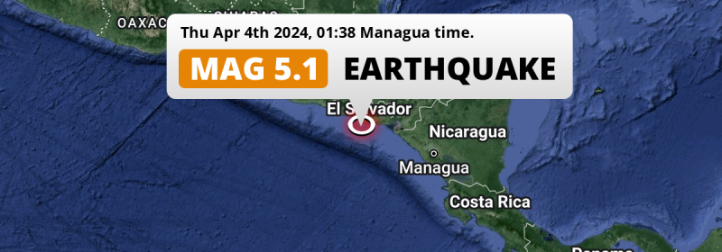
A significant MAG-5.1 earthquake struck in the North Pacific Ocean 94 kilometer from San Salvador, El Salvador in the night of Thursday April 4th, 2024. Other nearby countries are Honduras, Guatemala and Nicaragua.
Felt the earthquake? Share this article: 


Earthquake Summary
This earthquake hit under water in the North Pacific Ocean, 40 kilometers (25 mi) off the coast of El Salvador, 94 kilometer south-southeast of San Salvador. The center of this earthquake had a quite shallow depth of 55 km. Shallow earthquakes usually have a larger impact than earthquakes deep in the earth.
| Date and Time: | Apr 4, 2024 01:38AM (El Salvador Time) - Apr 4, 2024 07:38 Universal Time. |
|---|---|
| Location: | 94 km SSE of San Salvador, El Salvador. Coordinates 12°53'44"N 88°53'12"W. |
| Map: | 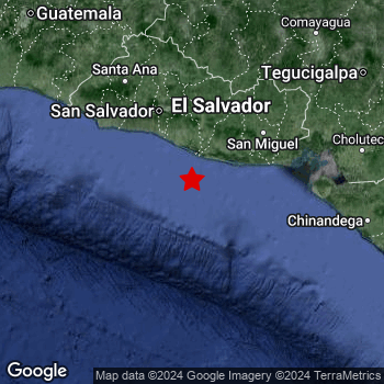 Map of area around epicenter. Click to open in Google Maps. |
| Magnitude: | MAG 5.1 Detected by 32 stations. Maximum Error Range ±0.055 . |
| Depth: | 55 km (34 mi) A quite shallow depth. |
| Tsunami Risk: | Low tsunami risk Earthquakes under MAG-6.5 do not usually cause tsunami's. Always stay cautious - More info here. |
Nearby towns and cities
4 countries can be found within 300km of the epicenter of this earthquake: El Salvador , Honduras , Guatemala and Nicaragua .
Located 56 kilometer (35 mi) southwest of the epicenter of this earthquake, Puerto El Triunfo (Usulután, El Salvador) is the nearest significant population center.
Multiple major population centers exist within 300km of the earthquake that struck today. San Salvador is located 94 km to the north-northwest. Tegucigalpa is located 224 km to the north-east. Guatemala City is located 262 km to the northwest.
A complete list of nearby places is included below.
Overview of nearby places
| Distance | Place |
|---|---|
| 56 km (35 mi) NE from epicenter |
Puerto El Triunfo Usulután, El Salvador. |
| 67 km (42 mi) N from epicenter |
Zacatecoluca La Paz, El Salvador. |
| 69 km (43 mi) NE from epicenter |
Usulután Usulután, El Salvador. |
| 79 km (49 mi) NE from epicenter |
San Rafael Oriente San Miguel, El Salvador. |
| 80 km (50 mi) NE from epicenter |
Santiago de María Usulután, El Salvador. |
| 81 km (50 mi) NW from epicenter |
La Libertad La Libertad, El Salvador. |
| 83 km (52 mi) N from epicenter |
San Vicente San Vicente, El Salvador. |
| 91 km (57 mi) N from epicenter |
Cojutepeque Cuscatlán, El Salvador. |
| 91 km (57 mi) NNW from epicenter |
San Marcos San Salvador, El Salvador. |
| 93 km (58 mi) NNW from epicenter |
Ilopango San Salvador, El Salvador. |
| 94 km (58 mi) NNW from epicenter |
Antiguo Cuscatlán La Libertad, El Salvador. |
| 94 km (58 mi) NNW from epicenter |
San Salvador San Salvador, El Salvador. |
| 95 km (59 mi) NNW from epicenter |
Soyapango San Salvador, El Salvador. |
| 97 km (60 mi) NNW from epicenter |
Delgado San Salvador, El Salvador. |
| 97 km (60 mi) NNW from epicenter |
Santa Tecla La Libertad, El Salvador. |
| 98 km (61 mi) NNW from epicenter |
Cuscatancingo San Salvador, El Salvador. |
| 98 km (61 mi) NNW from epicenter |
Mejicanos San Salvador, El Salvador. |
| 99 km (62 mi) N from epicenter |
San Martín Cuscatlán, El Salvador. |
| 99 km (62 mi) NNW from epicenter |
Ayutuxtepeque San Salvador, El Salvador. |
| 100 km (62 mi) NE from epicenter |
San Miguel San Miguel, El Salvador. |
| 106 km (66 mi) NNW from epicenter |
Apopa San Salvador, El Salvador. |
| 111 km (69 mi) NNE from epicenter |
Sensuntepeque Cabañas, El Salvador. |
| 112 km (70 mi) NNW from epicenter |
Quezaltepeque La Libertad, El Salvador. |
| 123 km (76 mi) NNW from epicenter |
Aguilares San Salvador, El Salvador. |
| 123 km (76 mi) NE from epicenter |
San Francisco Morazán, El Salvador. |
| 123 km (76 mi) ENE from epicenter |
La Unión La Unión, El Salvador. |
| 127 km (79 mi) NW from epicenter |
Izalco Sonsonate, El Salvador. |
| 127 km (79 mi) N from epicenter |
Chalatenango Chalatenango, El Salvador. |
| 128 km (80 mi) NW from epicenter |
Acajutla Sonsonate, El Salvador. |
| 129 km (80 mi) NW from epicenter |
Sonsonate Sonsonate, El Salvador. |
| 129 km (80 mi) NW from epicenter |
Sonzacate Sonsonate, El Salvador. |
| 142 km (88 mi) NNW from epicenter |
Santa Ana Santa Ana, El Salvador. |
| 149 km (93 mi) NW from epicenter |
Chalchuapa Santa Ana, El Salvador. |
| 154 km (96 mi) NW from epicenter |
Ahuachapán Ahuachapán, El Salvador. |
| 167 km (104 mi) ENE from epicenter |
San Lorenzo Valle, Honduras. |
| 171 km (106 mi) NNW from epicenter |
Metapán Santa Ana, El Salvador. |
| 188 km (117 mi) E from epicenter |
El Viejo Chinandega, Nicaragua. |
| 189 km (117 mi) ENE from epicenter |
Ciudad Choluteca Choluteca, Honduras. |
| 190 km (118 mi) NW from epicenter |
Jutiapa Jutiapa, Guatemala. |
| 192 km (119 mi) NNW from epicenter |
Esquipulas Chiquimula, Guatemala. |
| 193 km (120 mi) E from epicenter |
Chinandega Chinandega, Nicaragua. |
| 205 km (127 mi) NE from epicenter |
La Paz La Paz, Honduras. |
| 208 km (129 mi) N from epicenter |
Santa Rosa de Copán Copán, Honduras. |
| 219 km (136 mi) NE from epicenter |
Comayagua Comayagua, Honduras. |
| 224 km (139 mi) NE from epicenter |
Tegucigalpa Francisco Morazán, Honduras. |
| 224 km (139 mi) ESE from epicenter |
León León, Nicaragua. |
| 224 km (139 mi) NW from epicenter |
Barberena Santa Rosa, Guatemala. |
| 227 km (141 mi) NNW from epicenter |
Jalapa Jalapa, Guatemala. |
| 236 km (147 mi) NNE from epicenter |
Santa Bárbara Santa Bárbara, Honduras. |
| 241 km (150 mi) NNW from epicenter |
Zacapa Zacapa, Guatemala. |
| 251 km (156 mi) NW from epicenter |
Villa Canales Guatemala, Guatemala. |
| 254 km (158 mi) NW from epicenter |
Petapa Guatemala, Guatemala. |
| 254 km (158 mi) NW from epicenter |
Sanarate El Progreso, Guatemala. |
| 258 km (160 mi) NW from epicenter |
Villa Nueva Guatemala, Guatemala. |
| 258 km (160 mi) ENE from epicenter |
Somoto Madriz, Nicaragua. |
| 258 km (160 mi) NW from epicenter |
Escuintla Escuintla, Guatemala. |
| 262 km (163 mi) NW from epicenter |
Guatemala City Guatemala, Guatemala. |
| 266 km (165 mi) NW from epicenter |
Chinautla Guatemala, Guatemala. |
| 268 km (167 mi) NW from epicenter |
Mixco Guatemala, Guatemala. |
| 272 km (169 mi) NW from epicenter |
Antigua Guatemala Sacatepéquez, Guatemala. |
| 274 km (170 mi) ENE from epicenter |
Ocotal Nueva Segovia, Nicaragua. |
| 275 km (171 mi) E from epicenter |
Estelí Estelí, Nicaragua. |
| 278 km (173 mi) NW from epicenter |
San Juan Sacatepéquez Guatemala, Guatemala. |
| 279 km (173 mi) ENE from epicenter |
Danlí El Paraíso, Honduras. |
| 286 km (178 mi) NNE from epicenter |
Villanueva Cortés, Honduras. |
| 287 km (178 mi) N from epicenter |
Morales Izabal, Guatemala. |
| 287 km (178 mi) NW from epicenter |
Chimaltenango Chimaltenango, Guatemala. |
| 290 km (180 mi) NNW from epicenter |
Panzos Alta Verapaz, Guatemala. |
| 290 km (180 mi) NNW from epicenter |
Salamá Baja Verapaz, Guatemala. |
| 298 km (185 mi) ESE from epicenter |
Managua Managua, Nicaragua. |
Shaking reported by 3 people
People that feel an earthquake may report their experience to the US Geographic Survey. Currently, 3 people have reported shaking in 3 places, all within El Salvador.We keep updating this article as more ground reports become available. You may report that you felt this earthquake here.
Places with most reports:
- Antiguo Cuscatlán, La Libertad, El Salvador: 1 person.
- San Luis la Herradura, La Paz, El Salvador: 1 person.
- San Salvador, San Salvador, El Salvador: 1 person.
4 Aftershocks detected
After this earthquake struck, 4 smaller aftershocks occurred. A 3.2 magnitude earthquake hit 2 days later 49 km (30 mi) south-southeast of this earthquake.
In the days before this main shock, 4 smaller foreshocks were detected. A 3.6 magnitude earthquake hit 8 hrs earlier nearby.
Overview of foreshocks and aftershocks
| Classification | Magnitude | When | Where |
|---|---|---|---|
| Foreshock | M 3.1 |
3 days earlier Apr 1, 2024 04:33AM (El Salvador Time) | 59 km (37 mi) E from Main Shock. |
| Foreshock | M 2.5 |
2 days earlier Apr 2, 2024 01:22AM (El Salvador Time) | 19 km (12 mi) SE from Main Shock. |
| Foreshock | M 3.6 |
8 hrs earlier Apr 3, 2024 06:05PM (El Salvador Time) | 19 km (12 mi) W from Main Shock. |
| Foreshock | M 2.8 |
4 hrs earlier Apr 3, 2024 09:15PM (El Salvador Time) | 37 km (23 mi) SE from Main Shock. |
| Main Shock This Earthquake |
M 5.1 |
Apr 4, 2024 01:38AM (El Salvador Time) | - |
| Aftershock | M 2.8 |
7 hrs later Apr 4, 2024 08:08AM (El Salvador Time) | 26 km (16 mi) S from Main Shock. |
| Aftershock | M 2.6 |
9 hrs later Apr 4, 2024 10:46AM (El Salvador Time) | 73 km (45 mi) ESE from Main Shock. |
| Aftershock | M 3.1 |
2 days later Apr 6, 2024 04:59AM (El Salvador Time) | 34 km (21 mi) N from Main Shock. |
| Aftershock | M 3.2 |
2 days later Apr 6, 2024 06:30AM (El Salvador Time) | 49 km (30 mi) SSE from Main Shock. |
More earthquakes coming?
The risk of aftershocks decreases rapidly over time. Usually, aftershocks are at least one order of magnitude lower than a main shock.
It's always adviced to be cautious of the risk of a larger shock following any significant earthquake, however this risk is fairly small. There is a roughly 94 percent change that no larger main shock will follow in the days following this earthquake.
Read: How to Stay Safe during an Earthquake (cdc.gov).Earthquakes like this happen often in the region
Earthquakes of this strength are very common in the region. This is the strongest earthquake to hit since March 17th, 2024, when a 5.6 magnitude earthquake hit 146 km (91 mi) further east-southeast. An even stronger magnitude 7.3 earthquake struck on October 14th, 2014.
In total, 102 earthquakes with a magnitude of 5.1 or higher have been registered within 300km (186 mi) of this epicenter in the past 10 years. This comes down to an average of once every month.
Low tsunami risk
Based on early data it appears this earthquake was not strong enough (lower than MAG-6.5) to be likely to cause destructive tsunami's. However this earthquake appeared to have hit at a shallow depth under sea, so stay cautious and monitor advice from local authorities.
Tsunami Risk Factors
| Factor | Under Sea? | MAG-6.5 or stronger? | Shallow depth? |
|---|---|---|---|
| Explanation | Almost all tsunami's are caused by earthquakes with their epicenter under sea or very near the sea. However stay cautious in coastal areas as earthquakes on land may cause landslides into sea, potentially still causing a local tsunami. | Under MAG 6.5: Very unlikely to cause a tsunami. MAG 6.5 to 7.5: Destructive tsunami's do occur, but are uncommon. Likely to observe small sea level changes. MAG 7.6+: Earthquakes with these magnitudes might produce destructive tsunami's. |
Most destructive tsunami's are caused by shallow earthquakes with a depth between 0 and 100km under the surface of the earth. Deeper tsunami's are unlikely to displace to ocean floor. |
| This Earthquake | This earthquake appears to have struck under the sea. | Not this earthquake. This earthquake had a magnitude of 5.1. Earthquakes of this strength are unlikely to trigger a tsunami. |
This earthquake occurred at a depth of of 55 km (34 mi). Earthquakes this shallow could trigger a tsunami. |
Sources
Last updated 02/05/24 11:28 (). This article is automatically generated based on available data. We keep checking multiple sources for additional information. This article gets updated as new details on this earthquake become available.
- US Geographic Society (USGS): Earthquake us7000m9u3
- European-Mediterranean Seismological Centre (EMSC): Earthquake 20240404_0000099
- Geonames.org: World Cities Database
- Google Maps: Static API
- Earthquakelist.org: Historic Earthquakes Database
Share this article:
