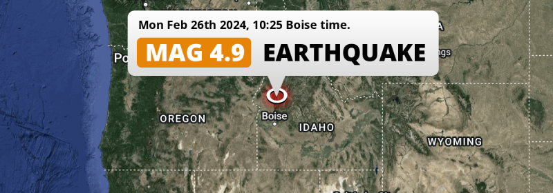
A shallow MAG-4.9 earthquake struck under land 54 miles from Boise in The United States in the morning of Monday February 26th, 2024. Shaking may have been felt by a total of 1.1 million people.
Felt the earthquake? Share this article: 


Earthquake Summary
The earthquake struck on land in The United States, 54 miles (87 km) north of Boise in Idaho. The center of this earthquake had a very shallow depth of 8 km. Shallow earthquakes usually have a larger impact than earthquakes deep in the earth.
| Date and Time: | Feb 26, 2024 10:25AM (Boise Time) - Feb 26, 2024 17:25 Universal Time. |
|---|---|
| Location: | 54 mi north of Boise, Idaho, The United States. Coordinates 44°23'27"N 116°6'39"W. |
| Map: | 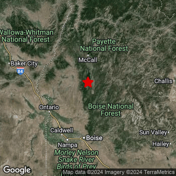 Map of area around epicenter. Click to open in Google Maps. |
| Magnitude: | MAG 4.9 Detected by 6 stations. Maximum Error Range ±0.3 . |
| Depth: | 8 mi (12 km) A very shallow depth. |
| Max. Intensity: | VI
Strong On the Modified Mercalli Scale. |
| Tsunami Risk: | Tsunami very unlikely While this was a shallow earthquake, it appears to have occurred under land with a magnitude not strong enough to cause tsunami's. Always stay cautious - More info here. |
Minimal impact predicted
Based on scientific estimates by the US Geographic Survey (USGS), the risk of high fatalities for this earthquake is classified at level GREEN (low). They expect an 69% likelyhood of between 0 and 1 fatalities, and a 98% chance that the number of fatalities falls no higher than 10.
The USGS classifies the economic impact of this earthquake at level GREEN (low). They expect an 65% likelyhood of between 0 and 1 million US Dollars in economic damage and impact, and a 96% chance that the economic impact of this earthquake falls no higher than 10 million USD.
Roughly 1.1 million people exposed to shaking
An estimated 1.1 million have been exposed to shaking (An MMI or Modified Mercalli Intensity level II or higher) as a result of this earthquake according scientific estimates published by the USGS.
Moderate shaking and very light damage may have been experienced by an estimated 940 people. At V, it is the highest MMI level this earthquake has caused. Intensity level II was experienced by the majority of people (around 0.8 million). In their region, very weak shaking and no damage can be expected.
| People | MMI Level | Shaking | Damage |
|---|---|---|---|
| 5,840 | I |
Not noticable | None |
| 848,100 | II |
Very weak | None |
| 264,900 | III |
Weak | Probably none |
| 6,400 | IV |
Light | Likely none |
| 940 | V |
Moderate | Very light |
| 0 | VI |
Strong | Light |
| 0 | VII |
Very Strong | Moderate |
| 0 | VIII |
Severe | Moderate to heavy |
| 0 | IX |
Violent | Heavy |
| 0 | X |
Extreme | Very heavy |
Nearby towns and cities
This earthquake may have been felt in The United States . Eagle in Idaho, The United States is the nearest significant place from the epicenter. The earthquake occurred 50 miles (80 km) north-northeast of Eagle. Eagle experienced an earthquake intensity (MMI Scale) of roughly III. That level implies weak shaking and probably no damage.
The table below provides an overview of all places in proximity of today's earthquake. Where available, the estimated intensity on the Modified Mercalli Intensity Scale in each place is included. Places where this information is omitted likely experienced little impact.
Overview of nearby places
| Distance | Place | Intensity (MMI) |
|---|---|---|
| 50 mi (80 km) SSW from epicenter |
Eagle Idaho, The United States. |
III
Weak |
| 54 mi (87 km) S from epicenter |
Boise Idaho, The United States. |
III
Weak |
| 55 mi (89 km) SSW from epicenter |
Meridian Idaho, The United States. |
II
Weak |
| 58 mi (93 km) SSW from epicenter |
Caldwell Idaho, The United States. |
II
Weak |
| 63 mi (101 km) SSW from epicenter |
Nampa Idaho, The United States. |
II
Weak |
| 64 mi (103 km) SSW from epicenter |
Kuna Idaho, The United States. |
II
Weak |
| 144 mi (231 km) NNW from epicenter |
Lewiston Orchards Idaho, The United States. |
|
| 147 mi (236 km) NNW from epicenter |
Lewiston Idaho, The United States. |
|
| 151 mi (243 km) SE from epicenter |
Twin Falls Idaho, The United States. |
|
| 158 mi (254 km) NW from epicenter |
Pendleton Oregon, The United States. |
|
| 158 mi (255 km) NW from epicenter |
Walla Walla Washington, The United States. |
II
Weak |
| 167 mi (269 km) NNW from epicenter |
Moscow Idaho, The United States. |
|
| 170 mi (273 km) NNW from epicenter |
Pullman Washington, The United States. |
|
| 185 mi (297 km) WNW from epicenter |
Hermiston Oregon, The United States. |
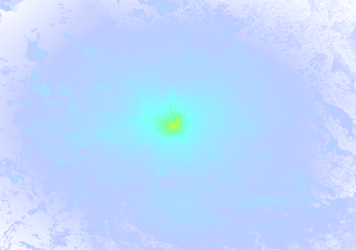
Earthquake Intensity Map
The intensity in shaking and damage by this earthquake is illustrated through the map below. The highest intensity measured for this earthquake is VI.
7 Aftershocks detected
This main shock was followed by 7 smaller aftershocks. A 3 magnitude earthquake hit 2 days later 2.9 mi (5 km) south of this earthquake.
Overview of foreshocks and aftershocks
| Classification | Magnitude | When | Where |
|---|---|---|---|
| Main Shock This Earthquake |
M 4.9 |
Feb 26, 2024 10:25AM (Boise Time) | - |
| Aftershock | M 2.8 |
20 mins later Feb 26, 2024 10:46AM (Boise Time) | 2.7 mi (4 km) SSW from Main Shock. |
| Aftershock | M 2.8 |
2 hrs later Feb 26, 2024 12:00PM (Boise Time) | 1.6 mi (2.6 km) SSW from Main Shock. |
| Aftershock | M 2.5 |
7 hrs later Feb 26, 2024 05:01PM (Boise Time) | 1.9 mi (3 km) S from Main Shock. |
| Aftershock | M 3.0 |
19 hrs later Feb 27, 2024 05:54AM (Boise Time) | 2.6 mi (4 km) SSW from Main Shock. |
| Aftershock | M 3.0 |
2 days later Feb 28, 2024 05:53PM (Boise Time) | 2.9 mi (5 km) S from Main Shock. |
| Aftershock | M 2.6 |
2 days later Feb 28, 2024 06:57PM (Boise Time) | 2.1 mi (3 km) SW from Main Shock. |
| Aftershock | M 2.5 |
3 days later Feb 29, 2024 07:21AM (Boise Time) | 46 mi (74 km) E from Main Shock. |
More earthquakes coming?
Earthquakes can create aftershocks. These are generally at least 1 magnitude lower than any main shock, and as time passes the chance and strength of aftershocks decreases.
In only six percent of cases, significant earthquakes are followed by a larger main shock, making the current earthquake a foreshock. While the chance of this happening is not so large, it is adviced to maintain cautiousness in the hours and days following a major earthquake.
Read: How to Stay Safe during an Earthquake (cdc.gov).This is the strongest earthquake in 4 years
Earthquakes of this strength are not so common in the region, but it's not the first time. This is the strongest earthquake to hit since March 31st, 2020, when a 6.5 magnitude earthquake hit 49 mi (79 km) further east. That was also the heaviest earthquake to hit the region in the past 10 years.
In total, 2 earthquakes with a magnitude of 4.9 or higher have been registered within 300km (186 mi) of this epicenter in the past 10 years. This comes down to an average of once every 5 years.
Tsunami very unlikely
While MAG-6.5+ earthquakes may cause tsunami's, it appears that the epicenter of this earthquake hit under land. In addition, the reported depth is deeper than 100km, making the risk of a tsunami even less likely. However always stay cautious and monitor advice from local authorities.
Tsunami Risk Factors
| Factor | Under Sea? | MAG-6.5 or stronger? | Shallow depth? |
|---|---|---|---|
| Explanation | Almost all tsunami's are caused by earthquakes with their epicenter under sea or very near the sea. However stay cautious in coastal areas as earthquakes on land may cause landslides into sea, potentially still causing a local tsunami. | Under MAG 6.5: Very unlikely to cause a tsunami. MAG 6.5 to 7.5: Destructive tsunami's do occur, but are uncommon. Likely to observe small sea level changes. MAG 7.6+: Earthquakes with these magnitudes might produce destructive tsunami's. |
Most destructive tsunami's are caused by shallow earthquakes with a depth between 0 and 100km under the surface of the earth. Deeper tsunami's are unlikely to displace to ocean floor. |
| This Earthquake | Not this earthquake. This earthquake appears to have struck on land far from any coast. |
Not this earthquake. This earthquake had a magnitude of 4.9. Earthquakes of this strength are unlikely to trigger a tsunami. |
This earthquake occurred at a depth of of 8 mi (12 km). Earthquakes this shallow could trigger a tsunami. |
Sources
Last updated 26/04/24 06:08 (). This article is automatically generated based on available data. We keep checking multiple sources for additional information. This article gets updated as new details on this earthquake become available.
- US Geographic Society (USGS): Earthquake us7000m1pd
- European-Mediterranean Seismological Centre (EMSC): Earthquake 20240226_0000174
- Geonames.org: World Cities Database
- Google Maps: Static API
- Earthquakelist.org: Historic Earthquakes Database
Share this article:
