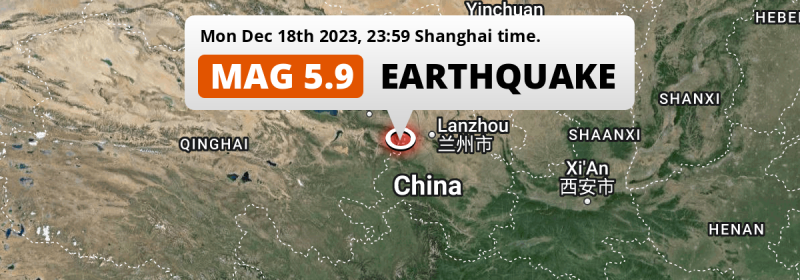
Under land 39 kilometer from Linxia Chengguanzhen in China, a DESTRUCTIVE and significant M5.9 earthquake occurred just before midnight of Monday December 18th, 2023. The earthquake struck near a very densely populated region. Earthquakes like this pose a high risk at damage and significant risk to cause loss of life.
Felt the earthquake? Share this article: 


Earthquake Summary
The earthquake struck on land in China, 39 kilometer (24 mi) west-northwest of Linxia Chengguanzhen in Gansu. The center of this earthquake had a very shallow depth of 12 km. Shallow earthquakes usually have a larger impact than earthquakes deep in the earth.
| Date and Time: | Dec 18, 2023 23:59 (Shanghai Time) - Dec 18, 2023 15:59 Universal Time. |
|---|---|
| Location: | 39 km WNW of Linxia Chengguanzhen, Gansu, China. Coordinates 35°44'19"N 102°48'54"E. |
| Map: | 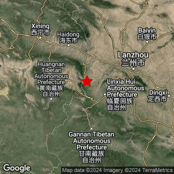 Map of area around epicenter. Click to open in Google Maps. |
| Magnitude: | MAG 5.9 Detected by 35 stations. Maximum Error Range ±0.052 . |
| Depth: | 12 km (7 mi) A very shallow depth. |
| Max. Intensity: | VIII
Severe On the Modified Mercalli Scale. |
| Tsunami Risk: | Tsunami very unlikely While this was a shallow earthquake, it appears to have occurred under land with a magnitude not strong enough to cause tsunami's. Always stay cautious - More info here. |
Significant impact predicted
The US Geographic Survey (USGS) describes the impact of this earthquake as follows:
At least 117 people killed and 784 injured in Gansu; 34 people killed, 198 injured and 13 missing in Qinghai. At least 15,000 houses destroyed and 207,000 damaged, communication, power and water outages occurred and rockfalls blocked roads in the Gansu-Qinghai area. A liquefaction induced landslide occurred in Minhe.
Based on scientific estimates by the USGS, the risk of high fatalities for this earthquake is classified at level YELLOW (significant). They expect an 38% likelyhood of between 1 and 10 fatalities, and a 91% chance that the number of fatalities falls no higher than 100.
The USGS classifies the economic impact of this earthquake at level RED (high). They expect an 35% likelyhood of between 1,000 and 10,000 million US Dollars in economic damage and impact, and a 92% chance that the economic impact of this earthquake falls between 10 and 100,000 million USD.
Roughly 17 million people exposed to shaking
This earthquake may have been felt by around 17 million people. That is the expected population size of the area exposed to a level of shaking of II or higher on the Modified Mercalli scale according to the USGS.
The highest earthquake impact level for this earthquake is VII, which corresponds with very strong shaking and likely moderate damage. Roughly 110,700 people are expected to be exposed to this level. Intensity level IV was experienced by the majority of people (around 10 million). In their region, light shaking and likely no damage can be expected. All exposure to shaking was within the borders of China .
| People | MMI Level | Shaking | Damage |
|---|---|---|---|
| 0 | I |
Not noticable | None |
| 0 | II |
Very weak | None |
| 5,009,000 | III |
Weak | Probably none |
| 10,460,000 | IV |
Light | Likely none |
| 932,300 | V |
Moderate | Very light |
| 174,600 | VI |
Strong | Light |
| 110,700 | VII |
Very Strong | Moderate |
| 0 | VIII |
Severe | Moderate to heavy |
| 0 | IX |
Violent | Heavy |
| 0 | X |
Extreme | Very heavy |
Nearby towns and cities
This earthquake may have been felt in China . The closest significant population center near the earthquake is Linxia Chengguanzhen in Gansu, China. Linxia Chengguanzhen is located 39 kilometer (24 mi) west-northwest of the epicenter. The intensity of shaking and damage in Linxia Chengguanzhen is estimated to be around level V on the Modified Mercalli Intensity scale (moderate shaking, very light damage).
Multiple large cities are in proximity of today's earthquake. Lanzhou is located 99 km to the east-northeast and experienced an intensity of IV (light shaking, likely no damage). Xining is located 137 km to the northwest and experienced an intensity of IV (light shaking, likely no damage). Linxia Chengguanzhen is located 39 km to the east-southeast and experienced an intensity of V (moderate shaking, very light damage).
A complete list of nearby places is included below. Estimated intensity data (MMI) sourced from a shake-map published by the US Geographic Survey is shown where available (cities without data probably experienced little impact).
Overview of nearby places
| Distance | Place | Intensity (MMI) |
|---|---|---|
| 39 km (24 mi) ESE from epicenter |
Linxia Chengguanzhen Gansu, China. |
V
Moderate |
| 65 km (40 mi) SSW from epicenter |
Labuleng Gansu, China. |
IV
Light |
| 84 km (52 mi) S from epicenter |
Hezuo Gansu, China. |
IV
Light |
| 90 km (56 mi) NNW from epicenter |
Nianbo Qinghai, China. |
IV
Light |
| 99 km (62 mi) ENE from epicenter |
Lanzhou Gansu, China. |
IV
Light |
| 127 km (79 mi) SSE from epicenter |
Lintan Chengguanzhen Gansu, China. |
IV
Light |
| 137 km (85 mi) NW from epicenter |
Xining Qinghai, China. |
IV
Light |
| 138 km (86 mi) SSE from epicenter |
Xincheng Gansu, China. |
IV
Light |
| 140 km (87 mi) NW from epicenter |
Lushar Qinghai, China. |
IV
Light |
| 142 km (88 mi) SSE from epicenter |
Liulin Gansu, China. |
III
Weak |
| 151 km (94 mi) NE from epicenter |
Baiyin Gansu, China. |
IV
Light |
| 154 km (96 mi) NW from epicenter |
Duoba Qinghai, China. |
IV
Light |
| 164 km (102 mi) E from epicenter |
Dingxi Gansu, China. |
IV
Light |
| 168 km (104 mi) NW from epicenter |
Qiaotou Qinghai, China. |
III
Weak |
| 190 km (118 mi) SSE from epicenter |
Dianga Gansu, China. |
III
Weak |
| 201 km (125 mi) ESE from epicenter |
Gaolou Gansu, China. |
III
Weak |
| 201 km (125 mi) NNW from epicenter |
Dongchuan Qinghai, China. |
III
Weak |
| 204 km (127 mi) NNW from epicenter |
Quankou Qinghai, China. |
III
Weak |
| 207 km (129 mi) ESE from epicenter |
Yuanyang Gansu, China. |
III
Weak |
| 209 km (130 mi) SE from epicenter |
Mali Gansu, China. |
III
Weak |
| 211 km (131 mi) NNW from epicenter |
Haomen Qinghai, China. |
III
Weak |
| 211 km (131 mi) SE from epicenter |
Hadapu Zhen Gansu, China. |
III
Weak |
| 214 km (133 mi) ESE from epicenter |
Shandan Gansu, China. |
III
Weak |
| 215 km (134 mi) SE from epicenter |
Lichuan Zhen Gansu, China. |
III
Weak |
| 220 km (137 mi) ESE from epicenter |
Wushan Gansu, China. |
III
Weak |
| 222 km (138 mi) ESE from epicenter |
Tange Gansu, China. |
III
Weak |
| 228 km (142 mi) NNW from epicenter |
Qingshizui Qinghai, China. |
III
Weak |
| 229 km (142 mi) ESE from epicenter |
Luomen Gansu, China. |
III
Weak |
| 235 km (146 mi) ESE from epicenter |
Simen Gansu, China. |
III
Weak |
| 235 km (146 mi) ESE from epicenter |
Dashi Gansu, China. |
|
| 236 km (147 mi) ESE from epicenter |
Pan’an Gansu, China. |
|
| 237 km (147 mi) SE from epicenter |
Tanchang Chengguanzhen Gansu, China. |
III
Weak |
| 243 km (151 mi) ESE from epicenter |
Anyuan Gansu, China. |
|
| 244 km (152 mi) N from epicenter |
Wuwei Gansu, China. |
|
| 252 km (157 mi) ESE from epicenter |
Baliwan Gansu, China. |
|
| 252 km (157 mi) ESE from epicenter |
Xinxing Gansu, China. |
|
| 254 km (158 mi) ESE from epicenter |
Gangu Chengguanzhen Gansu, China. |
|
| 259 km (161 mi) ESE from epicenter |
Liufeng Gansu, China. |
|
| 259 km (161 mi) ESE from epicenter |
Jinshan Gansu, China. |
|
| 263 km (163 mi) ESE from epicenter |
Guojia Gansu, China. |
|
| 269 km (167 mi) ESE from epicenter |
Anfu Gansu, China. |
|
| 275 km (171 mi) SE from epicenter |
Lixian Gansu, China. |
|
| 277 km (172 mi) ESE from epicenter |
Xingguo Gansu, China. |
|
| 280 km (174 mi) ESE from epicenter |
Lianhua Gansu, China. |
|
| 292 km (181 mi) SE from epicenter |
Yanguan Gansu, China. |
|
| 296 km (184 mi) ESE from epicenter |
Tianshui Gansu, China. |
|
| 309 km (192 mi) ESE from epicenter |
Beidao Gansu, China. |
|
| 312 km (194 mi) N from epicenter |
Jinchang Gansu, China. |
|
| 314 km (195 mi) E from epicenter |
Guyuan Ningxia Hui Autonomous Region, China. |
|
| 324 km (201 mi) SE from epicenter |
Longnan Gansu, China. |
|
| 351 km (218 mi) E from epicenter |
Pingliang Gansu, China. |
|
| 399 km (248 mi) NNW from epicenter |
Ehen Hudag Inner Mongolia, China. |
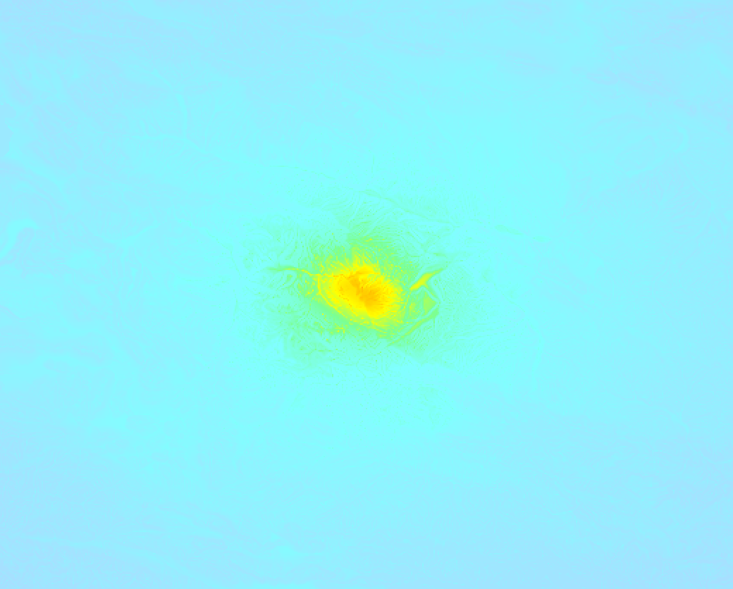
Earthquake Intensity Map
The intensity in shaking and damage by this earthquake is illustrated through the map below. The highest intensity measured for this earthquake is VII.
Shaking reported by 25 people
People that feel an earthquake may report their experience to the US Geographic Survey. Currently, 25 people have reported shaking in 12 places, all within China.We keep updating this article as more ground reports become available. You may report that you felt this earthquake here.
Places with most reports:
- Lanzhou, Gansu, China: 6 people.
- Linxia, Gansu, China: 3 people.
- Xining, Qinghai, China: 3 people.
- Chongqing, Chongqing, China: 2 people.
- Beidao, Gansu, China: 2 people.
- Xian, Shaanxi, China: 2 people.
- Huayang, Sichuan, China: 2 people.
- Aomen, Aomen, China: 1 person.
- Zhifang, Hubei, China: 1 person.
- Changsha, Hunan, China: 1 person.
6 Aftershocks detected
Since this main shock, 6 smaller aftershocks were detected. A 4.6 magnitude earthquake hit 2 days later 5 km (3 mi) north of this earthquake.
Overview of foreshocks and aftershocks
| Classification | Magnitude | When | Where |
|---|---|---|---|
| Main Shock This Earthquake |
M 5.9 |
Dec 18, 2023 23:59 (Shanghai Time) | - |
| Aftershock | M 4.6 |
25 mins later Dec 19, 2023 00:24 (Shanghai Time) | 2.2 km (1.4 mi) ENE from Main Shock. |
| Aftershock | M 4.6 |
37 mins later Dec 19, 2023 00:36 (Shanghai Time) | 0.7 km (0.4 mi) N from Main Shock. |
| Aftershock | M 4.5 |
44 mins later Dec 19, 2023 00:43 (Shanghai Time) | 7 km (5 mi) SSE from Main Shock. |
| Aftershock | M 4.2 |
57 mins later Dec 19, 2023 00:56 (Shanghai Time) | 5 km (2.9 mi) ENE from Main Shock. |
| Aftershock | M 4.5 |
1 hr later Dec 19, 2023 00:59 (Shanghai Time) | 1.4 km (0.9 mi) E from Main Shock. |
| Aftershock | M 4.6 |
2 days later Dec 21, 2023 04:02 (Shanghai Time) | 5 km (3 mi) N from Main Shock. |
More earthquakes coming?
The risk of aftershocks decreases rapidly over time. Usually, aftershocks are at least one order of magnitude lower than a main shock.
In only six percent of cases, significant earthquakes are followed by a larger main shock, making the current earthquake a foreshock. While the chance of this happening is not so large, it is adviced to maintain cautiousness in the hours and days following a major earthquake.
Read: How to Stay Safe during an Earthquake (cdc.gov).Earthquakes like this are common in the region
Earthquakes of this strength occur quite regularly in the region. This is the strongest earthquake to hit since January 7th, 2022, when a 6.6 magnitude earthquake hit 269 km (167 mi) further north-northwest. That was also the heaviest earthquake to hit the region in the past 10 years.
In total, 3 earthquakes with a magnitude of 5.9 or higher have been registered within 300km (186 mi) of this epicenter in the past 10 years. This comes down to an average of once every 3 years.
Tsunami very unlikely
While MAG-6.5+ earthquakes may cause tsunami's, it appears that the epicenter of this earthquake hit under land. In addition, the reported depth is deeper than 100km, making the risk of a tsunami even less likely. However always stay cautious and monitor advice from local authorities.
Tsunami Risk Factors
| Factor | Under Sea? | MAG-6.5 or stronger? | Shallow depth? |
|---|---|---|---|
| Explanation | Almost all tsunami's are caused by earthquakes with their epicenter under sea or very near the sea. However stay cautious in coastal areas as earthquakes on land may cause landslides into sea, potentially still causing a local tsunami. | Under MAG 6.5: Very unlikely to cause a tsunami. MAG 6.5 to 7.5: Destructive tsunami's do occur, but are uncommon. Likely to observe small sea level changes. MAG 7.6+: Earthquakes with these magnitudes might produce destructive tsunami's. |
Most destructive tsunami's are caused by shallow earthquakes with a depth between 0 and 100km under the surface of the earth. Deeper tsunami's are unlikely to displace to ocean floor. |
| This Earthquake | Not this earthquake. This earthquake appears to have struck on land far from any coast. |
Not this earthquake. This earthquake had a magnitude of 5.9. Earthquakes of this strength are unlikely to trigger a tsunami. |
This earthquake occurred at a depth of of 12 km (7 mi). Earthquakes this shallow could trigger a tsunami. |
Sources
Last updated 16/02/24 06:08 (). As more information on this earthquake becomes available this article will be updated. This article is automatically composed based on data originating from multiple sources.
- US Geographic Society (USGS): Earthquake us7000ljvg
- European-Mediterranean Seismological Centre (EMSC): Earthquake 20231218_0000190
- Geonames.org: World Cities Database
- Google Maps: Static API
- Earthquakelist.org: Historic Earthquakes Database
Share this article:
