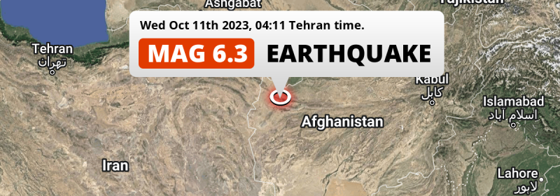
In the early morning of Wednesday October 11th, 2023, a DESTRUCTIVE and strong MAG-6.3 earthquake hit under land 25 kilometer from Herāt in Afghanistan. Earthquakes this strong in regions like this are likely to cause high numbers of casualties. Other countries near the epicenter include Iran and Turkmenistan.
Felt the earthquake? Share this article: 


Earthquake Summary
The earthquake struck on land in Afghanistan, 25 kilometer (16 mi) northwest of Herāt in Herat. The center of this earthquake had a very shallow depth of 4 km. Shallow earthquakes usually have a larger impact than earthquakes deep in the earth.
| Date and Time: | Oct 11, 2023 05:11AM (Kabul Time) - Oct 11, 2023 00:41 Universal Time. |
|---|---|
| Location: | 25 km NW of Herāt, Herat, Afghanistan. Coordinates 34°31'46"N 62°2'51"E. |
| Map: | 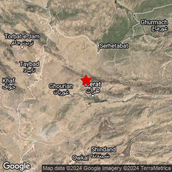 Map of area around epicenter. Click to open in Google Maps. |
| Magnitude: | MAG 6.3 Detected by 49 stations. Maximum Error Range ±0.044 . |
| Depth: | 4 km (2 mi) A very shallow depth. |
| Max. Intensity: | IX
Violent On the Modified Mercalli Scale. |
| Tsunami Risk: | Tsunami very unlikely While this was a shallow earthquake, it appears to have occurred under land with a magnitude not strong enough to cause tsunami's. Always stay cautious - More info here. |
High fatalities predicted
The US Geographic Survey (USGS) describes the impact of this earthquake as follows:
Three people killed, 169 people injured, and 700 homes destroyed at Chahak. Some homes and buildings damaged at Herat and a landslide was reported in the Herat-Torghundi area.
Based on scientific estimates by the USGS, the risk of high fatalities for this earthquake is classified at level RED (high). They expect an 40% likelyhood of between 1,000 and 10,000 fatalities, and a 96% chance that the number of fatalities falls between 10 and 100,000.
The USGS classifies the economic impact of this earthquake at level YELLOW (significant). They expect an 43% likelyhood of between 10 and 100 million US Dollars in economic damage and impact, and a 91% chance that the economic impact of this earthquake falls between 1 and 1,000 million USD.
Roughly 4.7 million people exposed to shaking
An estimated 4.7 million have been exposed to shaking (An MMI or Modified Mercalli Intensity level II or higher) as a result of this earthquake according scientific estimates published by the USGS.
Severe shaking and likely moderate to heavy damage may have been experienced by an estimated 4,950 people. At VIII, it is the highest MMI level this earthquake has caused. The majority of people (roughly 2.2 million) live in an area exposed to level IV, where light shaking and likely no damage is expected.
People in 3 countries have been exposed to shaking. In Afghanistan , around 3.7 million people, with impact levels up to VIII (severe shaking, likely moderate to heavy damage). In Iran , around 0.8 million people. People were exposed to shaking in Turkmenistan as well.
| People | MMI Level | Shaking | Damage |
|---|---|---|---|
| 0 | I |
Not noticable | None |
| 0 | II |
Very weak | None |
| 545,700 | III |
Weak | Probably none |
| 2,225,000 | IV |
Light | Likely none |
| 619,300 | V |
Moderate | Very light |
| 658,300 | VI |
Strong | Light |
| 598,100 | VII |
Very Strong | Moderate |
| 4,950 | VIII |
Severe | Moderate to heavy |
| 0 | IX |
Violent | Heavy |
| 0 | X |
Extreme | Very heavy |
Nearby towns and cities
This earthquake struck within proximity of multiple countries. Afghanistan , Iran and Turkmenistan are all within 300km distance of its epicenter.
The closest significant population center near the earthquake is Herāt in Herat, Afghanistan. Herāt is located 25 kilometer (16 mi) northwest of the epicenter. The intensity of shaking and damage in Herāt is estimated to be around level VII on the Modified Mercalli Intensity scale (very strong shaking, likely moderate damage).
Multiple major population centers exist within 300km of the earthquake that struck today. Herāt is located 25 km to the south-east and experienced an intensity of VII (very strong shaking, likely moderate damage). Mashhad is located 296 km to the northwest (intensity unknown, possibly low). Neyshābūr is located 349 km to the west-northwest (intensity unknown, possibly low).
An overview of nearby towns and cities is available in the overview below. If places don't have intensity data available, it likely means the experienced impact in those places was fairly small.
Overview of nearby places
| Distance | Place | Intensity (MMI) |
|---|---|---|
| 25 km (16 mi) SE from epicenter |
Herāt Herat, Afghanistan. |
VII
Very Strong |
| 50 km (31 mi) E from epicenter |
Karukh Herat, Afghanistan. |
V
Moderate |
| 91 km (57 mi) W from epicenter |
Kafir Qala Herat, Afghanistan. |
V
Moderate |
| 119 km (74 mi) W from epicenter |
Tāybād Razavi Khorasan, Iran. |
IV
Light |
| 137 km (85 mi) S from epicenter |
Shīnḏanḏ Herat, Afghanistan. |
IV
Light |
| 137 km (85 mi) S from epicenter |
Kushk Herat, Afghanistan. |
IV
Light |
| 152 km (94 mi) WNW from epicenter |
Torbat-e Jām Razavi Khorasan, Iran. |
V
Moderate |
| 207 km (129 mi) NE from epicenter |
Ghormach Badghis, Afghanistan. |
IV
Light |
| 213 km (132 mi) ESE from epicenter |
Shahrak Ghowr, Afghanistan. |
|
| 238 km (148 mi) NNW from epicenter |
Sarakhs Razavi Khorasan, Iran. |
|
| 240 km (149 mi) S from epicenter |
Farah Farah, Afghanistan. |
|
| 271 km (168 mi) WNW from epicenter |
Torbat-e Ḩeydarīyeh Razavi Khorasan, Iran. |
|
| 278 km (173 mi) WSW from epicenter |
Qā’en South Khorasan Province, Iran. |
|
| 293 km (182 mi) ENE from epicenter |
Maymana Faryab, Afghanistan. |
|
| 296 km (184 mi) NW from epicenter |
Mashhad Razavi Khorasan, Iran. |
|
| 309 km (192 mi) W from epicenter |
Gonābād Razavi Khorasan, Iran. |
|
| 309 km (192 mi) N from epicenter |
Yolöten Mary, Turkmenistan. |
|
| 320 km (199 mi) SW from epicenter |
Bīrjand South Khorasan Province, Iran. |
|
| 336 km (209 mi) WNW from epicenter |
Kāshmar Razavi Khorasan, Iran. |
|
| 341 km (212 mi) N from epicenter |
Mary Mary, Turkmenistan. |
|
| 341 km (212 mi) SSE from epicenter |
Khāsh Nimroz, Afghanistan. |
|
| 344 km (214 mi) N from epicenter |
Bayramaly Mary, Turkmenistan. |
|
| 346 km (215 mi) NNW from epicenter |
Tejen Ahal, Turkmenistan. |
|
| 349 km (217 mi) WNW from epicenter |
Neyshābūr Razavi Khorasan, Iran. |
|
| 354 km (220 mi) NW from epicenter |
Chenārān Razavi Khorasan, Iran. |
|
| 381 km (237 mi) WNW from epicenter |
Bardaskan Razavi Khorasan, Iran. |
|
| 382 km (237 mi) SE from epicenter |
Gereshk Helmand, Afghanistan. |
|
| 382 km (237 mi) NW from epicenter |
Kaka Ahal, Turkmenistan. |
|
| 387 km (240 mi) NE from epicenter |
Andkhōy Faryab, Afghanistan. |
|
| 392 km (244 mi) S from epicenter |
Zābol Sistan and Baluchestan, Iran. |
|
| 392 km (244 mi) SE from epicenter |
Lashkar Gāh Helmand, Afghanistan. |
|
| 397 km (247 mi) S from epicenter |
Zaranj Nimroz, Afghanistan. |
|
| 399 km (248 mi) ENE from epicenter |
Sar-e Pul Sar-e Pol, Afghanistan. |
Earthquake Intensity Map
The maximum intensity (MMI Scale) caused by this earthquake is VIII. The map below shows in which areas this earthquake was the most and least impactful. It is based on data from the US Geographic Survey.
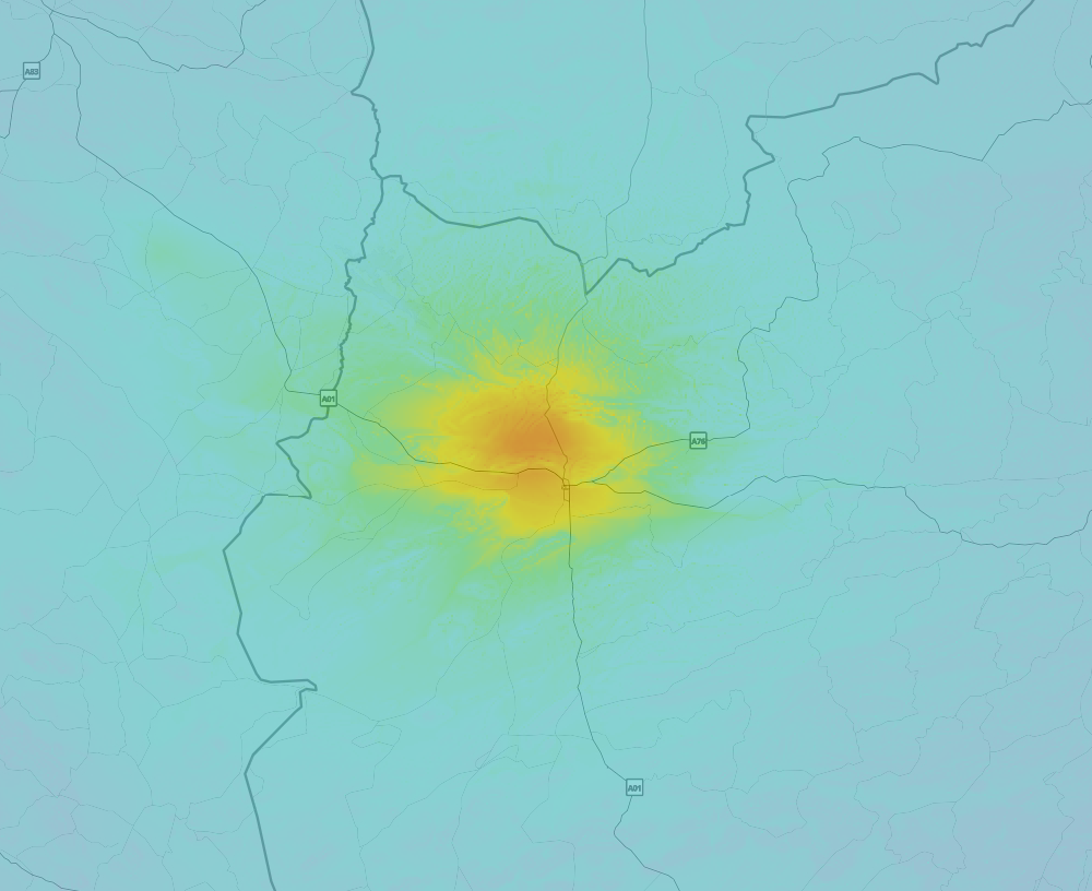
Shaking reported by 54 people in 3 countries
People that feel an earthquake may report their experience to the US Geographic Survey. Currently, 54 people have reported shaking in 12 places in 3 countries (Turkmenistan, Afghanistan, Iran).We keep updating this article as more ground reports become available. You may report that you felt this earthquake here.
Places with most reports:
- Meshed, Khorāsān-e Razavī, Iran: 25 people.
- Herāt, Herāt, Afghanistan: 11 people.
- Torbat Jam, Khorāsān-e Razavī, Iran: 4 people.
- Taibad, Khorāsān-e Razavī, Iran: 4 people.
- Aşgabat, Aşgabat, Turkmenistan: 2 people.
- Kabul, Kabul, Afghanistan: 2 people.
- Kalainow, Bādgīs, Afghanistan: 1 person.
- Herowābād, Ardabīl, Iran: 1 person.
- Solţānābād, Khorāsān-e Razavī, Iran: 1 person.
- Nayshabur, Khorāsān-e Razavī, Iran: 1 person.
15 Aftershocks detected
Since this main shock, 15 smaller aftershocks were detected. Just 11 mins after this main shock, an earthquake measuring MAG-5 was detected 9 km (6 mi) east-northeast of this earthquake.
This main shock was prefaced by 6 smaller foreshocks. Roughly 1 day before this earthquake, a foreshock measuring MAG-5.1 was detected nearby this earthquake.
Overview of foreshocks and aftershocks
| Classification | Magnitude | When | Where |
|---|---|---|---|
| Foreshock | M 4.2 |
3 days earlier Oct 8, 2023 07:17AM (Kabul Time) | 9 km (6 mi) S from Main Shock. |
| Foreshock | M 4.0 |
2 days earlier Oct 8, 2023 07:28PM (Kabul Time) | 16 km (10 mi) NW from Main Shock. |
| Foreshock | M 4.4 |
2 days earlier Oct 9, 2023 04:52AM (Kabul Time) | 12 km (8 mi) NNW from Main Shock. |
| Foreshock | M 4.9 |
2 days earlier Oct 9, 2023 11:24AM (Kabul Time) | 7 km (4 mi) N from Main Shock. |
| Foreshock | M 4.7 |
2 days earlier Oct 9, 2023 02:16PM (Kabul Time) | 18 km (11 mi) N from Main Shock. |
| Foreshock | M 5.1 |
1 day earlier Oct 9, 2023 06:00PM (Kabul Time) | 10 km (6 mi) N from Main Shock. |
| Main Shock This Earthquake |
M 6.3 |
Oct 11, 2023 05:11AM (Kabul Time) | - |
| Aftershock | M 5.0 |
11 mins later Oct 11, 2023 05:22AM (Kabul Time) | 9 km (6 mi) ENE from Main Shock. |
| Aftershock | M 4.5 |
17 mins later Oct 11, 2023 05:28AM (Kabul Time) | 3 km (2.1 mi) NW from Main Shock. |
| Aftershock | M 4.1 |
31 mins later Oct 11, 2023 05:43AM (Kabul Time) | 6 km (4 mi) SE from Main Shock. |
| Aftershock | M 4.2 |
59 mins later Oct 11, 2023 06:11AM (Kabul Time) | 8 km (5 mi) W from Main Shock. |
| Aftershock | M 4.0 |
1 hr later Oct 11, 2023 06:33AM (Kabul Time) | 32 km (20 mi) SSE from Main Shock. |
| Aftershock | M 4.3 |
2 hrs later Oct 11, 2023 07:08AM (Kabul Time) | 12 km (8 mi) S from Main Shock. |
| Aftershock | M 4.3 |
5 hrs later Oct 11, 2023 10:29AM (Kabul Time) | 9 km (6 mi) N from Main Shock. |
| Aftershock | M 4.1 |
1 day later Oct 12, 2023 01:50PM (Kabul Time) | 29 km (18 mi) W from Main Shock. |
| Aftershock | M 4.1 |
1 day later Oct 12, 2023 03:04PM (Kabul Time) | 21 km (13 mi) W from Main Shock. |
| Aftershock | M 4.5 |
1 day later Oct 12, 2023 04:50PM (Kabul Time) | 53 km (33 mi) N from Main Shock. |
| Aftershock | M 4.0 |
2 days later Oct 13, 2023 11:58AM (Kabul Time) | 6 km (4 mi) W from Main Shock. |
| Aftershock | M 4.5 |
2 days later Oct 13, 2023 02:34PM (Kabul Time) | 12 km (8 mi) SSW from Main Shock. |
| Aftershock | M 4.2 |
2 days later Oct 13, 2023 03:24PM (Kabul Time) | 11 km (7 mi) NNW from Main Shock. |
| Aftershock | M 4.2 |
2 days later Oct 13, 2023 03:43PM (Kabul Time) | 33 km (20 mi) NW from Main Shock. |
| Aftershock | M 4.5 |
3 days later Oct 13, 2023 10:15PM (Kabul Time) | 9 km (5 mi) NW from Main Shock. |
More earthquakes coming?
Earthquakes can create aftershocks. These are generally at least 1 magnitude lower than any main shock, and as time passes the chance and strength of aftershocks decreases.
It's always adviced to be cautious of the risk of a larger shock following any significant earthquake, however this risk is fairly small. There is a roughly 94 percent change that no larger main shock will follow in the days following this earthquake.
Read: How to Stay Safe during an Earthquake (cdc.gov).This is an unusually powerful earthquake
Earthquakes of this strength are not so common in the region, but it's not the first time. This is the strongest earthquake to hit since October 7th, 2023, when a 6.3 magnitude earthquake hit 16 km (10 mi) further west-northwest. That was also the heaviest earthquake to hit the region in the past 10 years.
In total, 2 earthquakes with a magnitude of 6.3 or higher have been registered within 300km (186 mi) of this epicenter in the past 10 years. This comes down to an average of once every 5 years.
Tsunami very unlikely
While MAG-6.5+ earthquakes may cause tsunami's, it appears that the epicenter of this earthquake hit under land. In addition, the reported depth is deeper than 100km, making the risk of a tsunami even less likely. However always stay cautious and monitor advice from local authorities.
Tsunami Risk Factors
| Factor | Under Sea? | MAG-6.5 or stronger? | Shallow depth? |
|---|---|---|---|
| Explanation | Almost all tsunami's are caused by earthquakes with their epicenter under sea or very near the sea. However stay cautious in coastal areas as earthquakes on land may cause landslides into sea, potentially still causing a local tsunami. | Under MAG 6.5: Very unlikely to cause a tsunami. MAG 6.5 to 7.5: Destructive tsunami's do occur, but are uncommon. Likely to observe small sea level changes. MAG 7.6+: Earthquakes with these magnitudes might produce destructive tsunami's. |
Most destructive tsunami's are caused by shallow earthquakes with a depth between 0 and 100km under the surface of the earth. Deeper tsunami's are unlikely to displace to ocean floor. |
| This Earthquake | Not this earthquake. This earthquake appears to have struck on land far from any coast. |
Not this earthquake. This earthquake had a magnitude of 6.3. Earthquakes of this strength are unlikely to trigger a tsunami. |
This earthquake occurred at a depth of of 4 km (2 mi). Earthquakes this shallow could trigger a tsunami. |
Sources
Last updated 09/12/23 05:58 (). As more information on this earthquake becomes available this article will be updated. This article is automatically composed based on data originating from multiple sources.
- US Geographic Society (USGS): Earthquake us6000len8
- European-Mediterranean Seismological Centre (EMSC): Earthquake 20231011_0000004
- Geonames.org: World Cities Database
- Google Maps: Static API
- Earthquakelist.org: Historic Earthquakes Database
Share this article:
