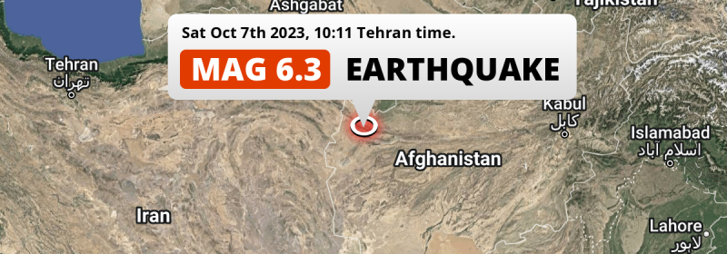
In the morning of Saturday October 7th, 2023, a DAMAGING and strong MAG-6.3 earthquake hit under land 37 kilometer from Herāt in Afghanistan. Earthquakes like this can cause significant economic damage and have a significant risk at casualties. Other countries near the epicenter include Iran and Turkmenistan.
Felt the earthquake? Share this article: 


Earthquake Summary
The earthquake struck on land in Afghanistan, 37 kilometer (23 mi) northwest of Herāt in Herat. The center of this earthquake had a very shallow depth of 14 km. Shallow earthquakes usually have a larger impact than earthquakes deep in the earth.
| Date and Time: | Oct 7, 2023 11:11AM (Kabul Time) - Oct 7, 2023 06:41 Universal Time. |
|---|---|
| Location: | 37 km NW of Herāt, Herat, Afghanistan. Coordinates 34°35'43"N 61°55'40"E. |
| Map: | 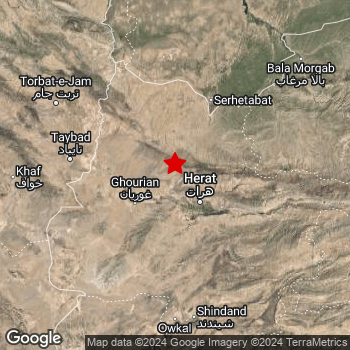 Map of area around epicenter. Click to open in Google Maps. |
| Magnitude: | MAG 6.3 Detected by 41 stations. Maximum Error Range ±0.048 . |
| Depth: | 14 km (9 mi) A very shallow depth. |
| Max. Intensity: | VIII
Severe On the Modified Mercalli Scale. |
| Tsunami Risk: | Tsunami very unlikely While this was a shallow earthquake, it appears to have occurred under land with a magnitude not strong enough to cause tsunami's. Always stay cautious - More info here. |
Significant impact predicted
The US Geographic Survey (USGS) describes the impact of this earthquake as follows:
At least 1482 people killed and 2100 injured, 21500 homes desstroyed and 38388 buildings damaged, and landslides reported in Herat Province.
Based on scientific estimates by the USGS, the risk of high fatalities for this earthquake is classified at level ORANGE (orange). They expect an 41% likelyhood of between 100 and 1,000 fatalities, and a 95% chance that the number of fatalities falls between 1 and 10,000.
The USGS classifies the economic impact of this earthquake at level YELLOW (significant). They expect an 35% likelyhood of between 1 and 10 million US Dollars in economic damage and impact, and a 91% chance that the economic impact of this earthquake falls no higher than 100 million USD.
Roughly 4.7 million people exposed to shaking
An estimated 4.7 million have been exposed to shaking (An MMI or Modified Mercalli Intensity level II or higher) as a result of this earthquake according scientific estimates published by the USGS.
Severe shaking and likely moderate to heavy damage may have been experienced by an estimated 130 people. At VIII, it is the highest MMI level this earthquake has caused. The majority of people (roughly 2.5 million) live in an area exposed to level IV, where light shaking and likely no damage is expected.
People in 3 countries have been exposed to shaking. In Afghanistan , around 3.6 million people, with impact levels up to VIII (severe shaking, likely moderate to heavy damage). In Iran , around 0.9 million people. People were exposed to shaking in Turkmenistan as well.
| People | MMI Level | Shaking | Damage |
|---|---|---|---|
| 0 | I |
Not noticable | None |
| 0 | II |
Very weak | None |
| 298,900 | III |
Weak | Probably none |
| 2,454,000 | IV |
Light | Likely none |
| 673,000 | V |
Moderate | Very light |
| 1,183,000 | VI |
Strong | Light |
| 59,810 | VII |
Very Strong | Moderate |
| 130 | VIII |
Severe | Moderate to heavy |
| 0 | IX |
Violent | Heavy |
| 0 | X |
Extreme | Very heavy |
Nearby towns and cities
This earthquake struck within proximity of multiple countries. Afghanistan , Iran and Turkmenistan are all within 300km distance of its epicenter.
The closest significant population center near the earthquake is Herāt in Herat, Afghanistan. Herāt is located 37 kilometer (23 mi) northwest of the epicenter. The intensity of shaking and damage in Herāt is estimated to be around level VI on the Modified Mercalli Intensity scale (strong shaking, probably light damage).
Multiple major population centers exist within 300km of the earthquake that struck today. Herāt is located 37 km to the south-east and experienced an intensity of VI (strong shaking, probably light damage). Mashhad is located 283 km to the northwest (intensity unknown, possibly low). Neyshābūr is located 336 km to the west-northwest (intensity unknown, possibly low).
An overview of nearby towns and cities is available in the overview below. If places don't have intensity data available, it likely means the experienced impact in those places was fairly small.
Overview of nearby places
| Distance | Place | Intensity (MMI) |
|---|---|---|
| 37 km (23 mi) SE from epicenter |
Herāt Herat, Afghanistan. |
VI
Strong |
| 62 km (39 mi) E from epicenter |
Karukh Herat, Afghanistan. |
V
Moderate |
| 79 km (49 mi) W from epicenter |
Kafir Qala Herat, Afghanistan. |
V
Moderate |
| 107 km (66 mi) W from epicenter |
Tāybād Razavi Khorasan, Iran. |
IV
Light |
| 139 km (86 mi) WNW from epicenter |
Torbat-e Jām Razavi Khorasan, Iran. |
IV
Light |
| 145 km (90 mi) S from epicenter |
Shīnḏanḏ Herat, Afghanistan. |
IV
Light |
| 145 km (90 mi) S from epicenter |
Kushk Herat, Afghanistan. |
IV
Light |
| 211 km (131 mi) NE from epicenter |
Ghormach Badghis, Afghanistan. |
IV
Light |
| 225 km (140 mi) ESE from epicenter |
Shahrak Ghowr, Afghanistan. |
|
| 228 km (142 mi) NNW from epicenter |
Sarakhs Razavi Khorasan, Iran. |
|
| 248 km (154 mi) S from epicenter |
Farah Farah, Afghanistan. |
|
| 258 km (160 mi) WNW from epicenter |
Torbat-e Ḩeydarīyeh Razavi Khorasan, Iran. |
|
| 270 km (168 mi) WSW from epicenter |
Qā’en South Khorasan Province, Iran. |
|
| 283 km (176 mi) NW from epicenter |
Mashhad Razavi Khorasan, Iran. |
|
| 298 km (185 mi) ENE from epicenter |
Maymana Faryab, Afghanistan. |
|
| 299 km (186 mi) W from epicenter |
Gonābād Razavi Khorasan, Iran. |
|
| 303 km (188 mi) N from epicenter |
Yolöten Mary, Turkmenistan. |
|
| 316 km (196 mi) SW from epicenter |
Bīrjand South Khorasan Province, Iran. |
|
| 324 km (201 mi) WNW from epicenter |
Kāshmar Razavi Khorasan, Iran. |
|
| 334 km (208 mi) N from epicenter |
Mary Mary, Turkmenistan. |
|
| 335 km (208 mi) NNW from epicenter |
Tejen Ahal, Turkmenistan. |
|
| 336 km (209 mi) WNW from epicenter |
Neyshābūr Razavi Khorasan, Iran. |
|
| 337 km (209 mi) N from epicenter |
Bayramaly Mary, Turkmenistan. |
|
| 341 km (212 mi) NW from epicenter |
Chenārān Razavi Khorasan, Iran. |
|
| 350 km (217 mi) SSE from epicenter |
Khāsh Nimroz, Afghanistan. |
|
| 368 km (229 mi) W from epicenter |
Bardaskan Razavi Khorasan, Iran. |
|
| 370 km (230 mi) NW from epicenter |
Kaka Ahal, Turkmenistan. |
|
| 390 km (242 mi) NE from epicenter |
Andkhōy Faryab, Afghanistan. |
|
| 394 km (245 mi) SE from epicenter |
Gereshk Helmand, Afghanistan. |
|
| 398 km (247 mi) S from epicenter |
Zābol Sistan and Baluchestan, Iran. |
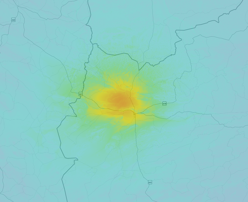
Earthquake Intensity Map
The maximum intensity (MMI Scale) caused by this earthquake is VIII. The map below shows in which areas this earthquake was the most and least impactful. It is based on data from the US Geographic Survey.
Shaking reported by 3 people
People that feel an earthquake may report their experience to the US Geographic Survey. Currently, 3 people have reported shaking in 2 places in Afghanistan.We keep updating this article as more ground reports become available. You may report that you felt this earthquake here.
Places with most reports:
- Herāt, Herāt, Afghanistan: 2 people.
- Kabul, Kabul, Afghanistan: 1 person.
20 Aftershocks detected
Since this main shock, 20 smaller aftershocks were detected. Just 32 mins after this main shock, an earthquake measuring MAG-6.3 was detected 5 km (3 mi) west-southwest of this earthquake.
Overview of foreshocks and aftershocks
| Classification | Magnitude | When | Where |
|---|---|---|---|
| Main Shock This Earthquake |
M 6.3 |
Oct 7, 2023 11:11AM (Kabul Time) | - |
| Aftershock | M 5.4 |
9 mins later Oct 7, 2023 11:19AM (Kabul Time) | 9 km (6 mi) S from Main Shock. |
| Aftershock | M 4.7 |
30 mins later Oct 7, 2023 11:40AM (Kabul Time) | 5 km (3 mi) SSE from Main Shock. |
| Aftershock | M 6.3 |
32 mins later Oct 7, 2023 11:42AM (Kabul Time) | 5 km (3 mi) WSW from Main Shock. |
| Aftershock | M 5.2 |
35 mins later Oct 7, 2023 11:46AM (Kabul Time) | 12 km (8 mi) SSW from Main Shock. |
| Aftershock | M 4.5 |
48 mins later Oct 7, 2023 11:58AM (Kabul Time) | 16 km (10 mi) WNW from Main Shock. |
| Aftershock | M 5.9 |
59 mins later Oct 7, 2023 12:10PM (Kabul Time) | 8 km (5 mi) ENE from Main Shock. |
| Aftershock | M 4.6 |
1 hr later Oct 7, 2023 12:36PM (Kabul Time) | 5 km (3 mi) N from Main Shock. |
| Aftershock | M 4.4 |
2 hrs later Oct 7, 2023 01:35PM (Kabul Time) | 6 km (4 mi) SSE from Main Shock. |
| Aftershock | M 4.1 |
2 hrs later Oct 7, 2023 01:38PM (Kabul Time) | 27 km (16 mi) SSW from Main Shock. |
| Aftershock | M 4.8 |
3 hrs later Oct 7, 2023 01:57PM (Kabul Time) | 8 km (5 mi) SSE from Main Shock. |
| Aftershock | M 4.9 |
3 hrs later Oct 7, 2023 02:10PM (Kabul Time) | 7 km (4 mi) NE from Main Shock. |
| Aftershock | M 4.2 |
3 hrs later Oct 7, 2023 02:35PM (Kabul Time) | 46 km (28 mi) ENE from Main Shock. |
| Aftershock | M 4.2 |
5 hrs later Oct 7, 2023 03:57PM (Kabul Time) | 8 km (5 mi) E from Main Shock. |
| Aftershock | M 4.2 |
12 hrs later Oct 7, 2023 11:02PM (Kabul Time) | 9 km (5 mi) N from Main Shock. |
| Aftershock | M 4.2 |
20 hrs later Oct 8, 2023 07:17AM (Kabul Time) | 19 km (12 mi) SE from Main Shock. |
| Aftershock | M 4.0 |
1 day later Oct 8, 2023 07:28PM (Kabul Time) | 3 km (1.9 mi) NNW from Main Shock. |
| Aftershock | M 4.4 |
2 days later Oct 9, 2023 04:52AM (Kabul Time) | 7 km (4 mi) NE from Main Shock. |
| Aftershock | M 4.9 |
2 days later Oct 9, 2023 11:24AM (Kabul Time) | 10 km (6 mi) ENE from Main Shock. |
| Aftershock | M 4.7 |
2 days later Oct 9, 2023 02:16PM (Kabul Time) | 19 km (12 mi) NNE from Main Shock. |
| Aftershock | M 5.1 |
2 days later Oct 9, 2023 06:00PM (Kabul Time) | 9 km (6 mi) ENE from Main Shock. |
More earthquakes coming?
Earthquakes can create aftershocks. These are generally at least 1 magnitude lower than any main shock, and as time passes the chance and strength of aftershocks decreases.
It's always adviced to be cautious of the risk of a larger shock following any significant earthquake, however this risk is fairly small. There is a roughly 94 percent change that no larger main shock will follow in the days following this earthquake.
Read: How to Stay Safe during an Earthquake (cdc.gov).This is an unusually powerful earthquake
No earthquake of this strength has struck this region for a long time. Our data goes back 10 years, and no earthquakes measuring a magnitude of 6.3 or higher have been detected within 300 km (186 mi) of this epicenter.
Tsunami very unlikely
While MAG-6.5+ earthquakes may cause tsunami's, it appears that the epicenter of this earthquake hit under land. In addition, the reported depth is deeper than 100km, making the risk of a tsunami even less likely. However always stay cautious and monitor advice from local authorities.
Tsunami Risk Factors
| Factor | Under Sea? | MAG-6.5 or stronger? | Shallow depth? |
|---|---|---|---|
| Explanation | Almost all tsunami's are caused by earthquakes with their epicenter under sea or very near the sea. However stay cautious in coastal areas as earthquakes on land may cause landslides into sea, potentially still causing a local tsunami. | Under MAG 6.5: Very unlikely to cause a tsunami. MAG 6.5 to 7.5: Destructive tsunami's do occur, but are uncommon. Likely to observe small sea level changes. MAG 7.6+: Earthquakes with these magnitudes might produce destructive tsunami's. |
Most destructive tsunami's are caused by shallow earthquakes with a depth between 0 and 100km under the surface of the earth. Deeper tsunami's are unlikely to displace to ocean floor. |
| This Earthquake | Not this earthquake. This earthquake appears to have struck on land far from any coast. |
Not this earthquake. This earthquake had a magnitude of 6.3. Earthquakes of this strength are unlikely to trigger a tsunami. |
This earthquake occurred at a depth of of 14 km (9 mi). Earthquakes this shallow could trigger a tsunami. |
Sources
Last updated 05/12/23 07:18 (). As more information on this earthquake becomes available this article will be updated. This article is automatically composed based on data originating from multiple sources.
- US Geographic Society (USGS): Earthquake us6000ldpg
- European-Mediterranean Seismological Centre (EMSC): Earthquake 20231007_0000075
- Geonames.org: World Cities Database
- Google Maps: Static API
- Earthquakelist.org: Historic Earthquakes Database
Share this article:
