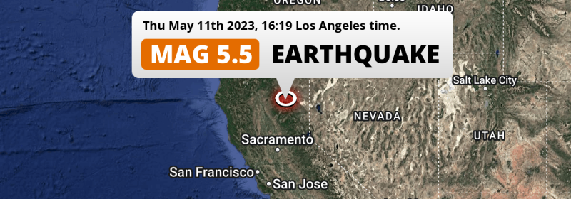
A shallow and significant Magnitude 5.5 earthquake struck under land 51 miles from Chico in The United States in the late afternoon of Thursday May 11th, 2023. The USGS has indicated there is a potential risk at tsunami's following this earthquake.
Felt the earthquake? Share this article: 


Earthquake Summary
The earthquake struck on land in The United States, 51 miles (82 km) north-east of Chico in California. The center of this earthquake had a very shallow depth of 4 km. Shallow earthquakes usually have a larger impact than earthquakes deep in the earth.
| Date and Time: | May 11, 2023 04:19PM (Los Angeles Time) - May 11, 2023 23:19 Universal Time. |
|---|---|
| Location: | 51 mi NE of Chico, California, The United States. Coordinates 40°12'15"N 121°6'34"W. |
| Map: | 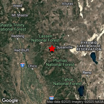 Map of area around epicenter. Click to open in Google Maps. |
| Magnitude: | MAG 5.5 Detected by 10 stations. Maximum Error Range ±0.2 . |
| Depth: | 4 mi (6 km) A very shallow depth. |
| Max. Intensity: | VII
Very Strong On the Modified Mercalli Scale. |
| Tsunami Risk: | Potential tsunami risk The USGS has indicated there is a potential risk at tsunami's following this earthquake. Always stay cautious - More info here. |
Potential tsunami risk
There is a potential tsunami risk in the aftermath of this earthquake, immediately evacuate to higher grounds away from coastal areas and monitor advice from local authorities. The US Geographic Survey organization has indicated a potential risk for tsunami's following this earthquake.
Tsunami Risk Factors
| Factor | Under Sea? | MAG-6.5 or stronger? | Shallow depth? |
|---|---|---|---|
| Explanation | Almost all tsunami's are caused by earthquakes with their epicenter under sea or very near the sea. However stay cautious in coastal areas as earthquakes on land may cause landslides into sea, potentially still causing a local tsunami. | Under MAG 6.5: Very unlikely to cause a tsunami. MAG 6.5 to 7.5: Destructive tsunami's do occur, but are uncommon. Likely to observe small sea level changes. MAG 7.6+: Earthquakes with these magnitudes might produce destructive tsunami's. |
Most destructive tsunami's are caused by shallow earthquakes with a depth between 0 and 100km under the surface of the earth. Deeper tsunami's are unlikely to displace to ocean floor. |
| This Earthquake | Not this earthquake. This earthquake appears to have struck on land far from any coast. |
Not this earthquake. This earthquake had a magnitude of 5.5. Earthquakes of this strength are unlikely to trigger a tsunami. |
This earthquake occurred at a depth of of 4 mi (6 km). Earthquakes this shallow could trigger a tsunami. |
Minimal impact predicted
Based on scientific estimates by the US Geographic Survey (USGS), the risk of high fatalities for this earthquake is classified at level GREEN (low). They expect an 65% likelyhood of between 0 and 1 fatalities, and a 96% chance that the number of fatalities falls no higher than 10.
The USGS classifies the economic impact of this earthquake at level GREEN (low). They expect an 100% likelyhood of between 0 and 1 million US Dollars in economic damage and impact.
Roughly 4.5 million people exposed to shaking
An estimated 4.5 million have been exposed to shaking (An MMI or Modified Mercalli Intensity level II or higher) as a result of this earthquake according scientific estimates published by the USGS.
Strong shaking and probably light damage may have been experienced by an estimated 1,240 people. At VI, it is the highest MMI level this earthquake has caused. The majority of people (roughly 3.1 million) live in an area exposed to level III, where weak shaking and probably no damage is expected.
| People | MMI Level | Shaking | Damage |
|---|---|---|---|
| 4,210 | I |
Not noticable | None |
| 1,273,000 | II |
Very weak | None |
| 3,147,000 | III |
Weak | Probably none |
| 88,880 | IV |
Light | Likely none |
| 8,370 | V |
Moderate | Very light |
| 1,240 | VI |
Strong | Light |
| 0 | VII |
Very Strong | Moderate |
| 0 | VIII |
Severe | Moderate to heavy |
| 0 | IX |
Violent | Heavy |
| 0 | X |
Extreme | Very heavy |
Nearby towns and cities
This earthquake may have been felt in The United States . Susanville in California, The United States is the nearest significant place from the epicenter. The earthquake occurred 28 miles (45 km) west-southwest of Susanville. The intensity of shaking and damage in Susanville is estimated to be around level IV on the Modified Mercalli Intensity scale (light shaking, likely no damage).
Multiple major population centers exist within 300km of the earthquake that struck today. San Francisco is located 182 mi to the south-southwest (intensity unknown, possibly low). Sacramento is located 114 mi to the south and experienced an intensity of III (weak shaking, probably no damage). Reno is located 83 mi to the south-east and experienced an intensity of III (weak shaking, probably no damage).
An overview of nearby towns and cities is available in the overview below. If places don't have intensity data available, it likely means the experienced impact in those places was fairly small.
Overview of nearby places
| Distance | Place | Intensity (MMI) |
|---|---|---|
| 28 mi (45 km) ENE from epicenter |
Susanville California, The United States. |
IV
Light |
| 41 mi (66 km) SW from epicenter |
Paradise California, The United States. |
IV
Light |
| 51 mi (82 km) SW from epicenter |
Chico California, The United States. |
III
Weak |
| 53 mi (86 km) SSW from epicenter |
Oroville California, The United States. |
III
Weak |
| 73 mi (117 km) WNW from epicenter |
Redding California, The United States. |
III
Weak |
| 78 mi (126 km) SE from epicenter |
Truckee California, The United States. |
III
Weak |
| 78 mi (126 km) SSW from epicenter |
Linda California, The United States. |
III
Weak |
| 78 mi (126 km) SSW from epicenter |
Yuba City California, The United States. |
III
Weak |
| 80 mi (129 km) SSW from epicenter |
South Yuba City California, The United States. |
III
Weak |
| 82 mi (132 km) ESE from epicenter |
Sun Valley Nevada, The United States. |
II
Weak |
| 83 mi (134 km) SE from epicenter |
Reno Nevada, The United States. |
III
Weak |
| 84 mi (135 km) ESE from epicenter |
Spanish Springs Nevada, The United States. |
III
Weak |
| 86 mi (138 km) ESE from epicenter |
Sparks Nevada, The United States. |
III
Weak |
| 91 mi (147 km) S from epicenter |
Lincoln California, The United States. |
III
Weak |
| 98 mi (158 km) S from epicenter |
Rocklin California, The United States. |
III
Weak |
| 99 mi (160 km) S from epicenter |
Granite Bay California, The United States. |
III
Weak |
| 101 mi (162 km) S from epicenter |
Roseville California, The United States. |
III
Weak |
| 101 mi (163 km) SE from epicenter |
Carson City Nevada, The United States. |
II
Weak |
| 104 mi (167 km) S from epicenter |
Antelope California, The United States. |
III
Weak |
| 104 mi (167 km) S from epicenter |
Citrus Heights California, The United States. |
III
Weak |
| 105 mi (169 km) S from epicenter |
El Dorado Hills California, The United States. |
II
Weak |
| 106 mi (170 km) S from epicenter |
Folsom California, The United States. |
III
Weak |
| 106 mi (170 km) S from epicenter |
North Highlands California, The United States. |
III
Weak |
| 106 mi (170 km) S from epicenter |
Orangevale California, The United States. |
III
Weak |
| 106 mi (171 km) S from epicenter |
Foothill Farms California, The United States. |
III
Weak |
| 106 mi (171 km) SE from epicenter |
South Lake Tahoe California, The United States. |
III
Weak |
| 107 mi (172 km) ESE from epicenter |
Fernley Nevada, The United States. |
III
Weak |
| 108 mi (174 km) S from epicenter |
Fair Oaks California, The United States. |
III
Weak |
| 110 mi (177 km) S from epicenter |
Carmichael California, The United States. |
III
Weak |
| 111 mi (179 km) SSW from epicenter |
Woodland California, The United States. |
III
Weak |
| 112 mi (180 km) S from epicenter |
Arden-Arcade California, The United States. |
III
Weak |
| 112 mi (180 km) S from epicenter |
Rancho Cordova California, The United States. |
III
Weak |
| 114 mi (183 km) S from epicenter |
Sacramento California, The United States. |
III
Weak |
| 114 mi (184 km) S from epicenter |
West Sacramento California, The United States. |
III
Weak |
| 115 mi (185 km) S from epicenter |
Rosemont California, The United States. |
III
Weak |
| 119 mi (192 km) SSW from epicenter |
Davis California, The United States. |
III
Weak |
| 119 mi (192 km) S from epicenter |
Florin California, The United States. |
III
Weak |
| 124 mi (200 km) S from epicenter |
Laguna California, The United States. |
III
Weak |
| 125 mi (201 km) S from epicenter |
Elk Grove California, The United States. |
III
Weak |
| 136 mi (219 km) SSW from epicenter |
Vacaville California, The United States. |
|
| 144 mi (232 km) SSW from epicenter |
Fairfield California, The United States. |
|
| 149 mi (240 km) SW from epicenter |
Santa Rosa California, The United States. |
II
Weak |
| 155 mi (250 km) S from epicenter |
Stockton California, The United States. |
|
| 157 mi (252 km) SSW from epicenter |
Antioch California, The United States. |
|
| 158 mi (254 km) SSW from epicenter |
Vallejo California, The United States. |
|
| 162 mi (260 km) SSW from epicenter |
Concord California, The United States. |
|
| 173 mi (278 km) SSW from epicenter |
Berkeley California, The United States. |
|
| 173 mi (278 km) NNW from epicenter |
Medford Oregon, The United States. |
|
| 177 mi (285 km) SSW from epicenter |
Oakland California, The United States. |
|
| 177 mi (285 km) S from epicenter |
Modesto California, The United States. |
|
| 182 mi (293 km) SSW from epicenter |
San Francisco California, The United States. |
|
| 183 mi (294 km) SSW from epicenter |
Hayward California, The United States. |
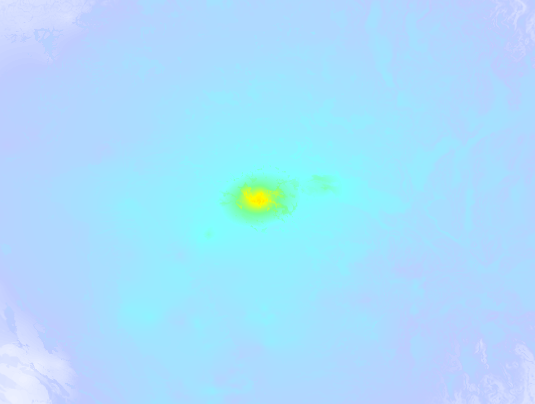
Earthquake Intensity Map
The graph below overlays a map of the region around the epicenter with earthquake intensity data provided by the US Geographic Survey. The highest intensity level detected for this earthquake is VI.
27 Aftershocks detected
Since this main shock, 27 smaller aftershocks were detected. At a distance of 0.7 mi (1.2 km) south-east of this earthquake, an aftershock struck 11 hrs later. It measured a magnitude of 5.2
Overview of foreshocks and aftershocks
| Classification | Magnitude | When | Where |
|---|---|---|---|
| Main Shock This Earthquake |
M 5.5 |
May 11, 2023 04:19PM (Los Angeles Time) | - |
| Aftershock | M 2.8 |
4 mins later May 11, 2023 04:23PM (Los Angeles Time) | 3 mi (6 km) WNW from Main Shock. |
| Aftershock | M 2.6 |
10 mins later May 11, 2023 04:29PM (Los Angeles Time) | 0.2 mi (0.3 km) WSW from Main Shock. |
| Aftershock | M 2.6 |
11 mins later May 11, 2023 04:30PM (Los Angeles Time) | 1.4 mi (2.2 km) ENE from Main Shock. |
| Aftershock | M 2.6 |
19 mins later May 11, 2023 04:38PM (Los Angeles Time) | 0.2 mi (0.3 km) E from Main Shock. |
| Aftershock | M 2.5 |
26 mins later May 11, 2023 04:45PM (Los Angeles Time) | 3 mi (5 km) WNW from Main Shock. |
| Aftershock | M 3.0 |
47 mins later May 11, 2023 05:06PM (Los Angeles Time) | 2.5 mi (4 km) WNW from Main Shock. |
| Aftershock | M 2.8 |
1 hr later May 11, 2023 05:38PM (Los Angeles Time) | 2.4 mi (4 km) WNW from Main Shock. |
| Aftershock | M 2.7 |
3 hrs later May 11, 2023 07:40PM (Los Angeles Time) | 3 mi (5 km) NW from Main Shock. |
| Aftershock | M 3.8 |
4 hrs later May 11, 2023 07:54PM (Los Angeles Time) | 0.7 mi (1.2 km) SE from Main Shock. |
| Aftershock | M 2.8 |
6 hrs later May 11, 2023 10:17PM (Los Angeles Time) | 0.7 mi (1.2 km) SE from Main Shock. |
| Aftershock | M 3.0 |
6 hrs later May 11, 2023 10:45PM (Los Angeles Time) | 0.7 mi (1.1 km) SE from Main Shock. |
| Aftershock | M 2.6 |
9 hrs later May 12, 2023 01:20AM (Los Angeles Time) | 3 mi (6 km) NW from Main Shock. |
| Aftershock | M 5.2 |
11 hrs later May 12, 2023 03:18AM (Los Angeles Time) | 0.7 mi (1.2 km) SE from Main Shock. |
| Aftershock | M 2.5 |
11 hrs later May 12, 2023 03:24AM (Los Angeles Time) | 1 mi (1.6 km) S from Main Shock. |
| Aftershock | M 2.7 |
12 hrs later May 12, 2023 04:23AM (Los Angeles Time) | 1.2 mi (2 km) WSW from Main Shock. |
| Aftershock | M 2.8 |
13 hrs later May 12, 2023 05:32AM (Los Angeles Time) | 1.1 mi (1.8 km) SSW from Main Shock. |
| Aftershock | M 3.1 |
13 hrs later May 12, 2023 05:42AM (Los Angeles Time) | 1.1 mi (1.8 km) SE from Main Shock. |
| Aftershock | M 2.9 |
14 hrs later May 12, 2023 06:29AM (Los Angeles Time) | 2.5 mi (4 km) WNW from Main Shock. |
| Aftershock | M 2.9 |
15 hrs later May 12, 2023 06:50AM (Los Angeles Time) | 0.5 mi (0.8 km) SSE from Main Shock. |
| Aftershock | M 2.9 |
16 hrs later May 12, 2023 08:24AM (Los Angeles Time) | 1.2 mi (2 km) SSW from Main Shock. |
| Aftershock | M 2.8 |
2 days later May 13, 2023 04:37AM (Los Angeles Time) | 2.4 mi (4 km) W from Main Shock. |
| Aftershock | M 3.0 |
2 days later May 13, 2023 05:01AM (Los Angeles Time) | 2.2 mi (4 km) W from Main Shock. |
| Aftershock | M 2.8 |
2 days later May 13, 2023 06:33AM (Los Angeles Time) | 2.5 mi (4 km) W from Main Shock. |
| Aftershock | M 2.5 |
2 days later May 13, 2023 07:19AM (Los Angeles Time) | 2.7 mi (4 km) WNW from Main Shock. |
| Aftershock | M 2.5 |
2 days later May 13, 2023 01:18PM (Los Angeles Time) | 3 mi (5 km) NW from Main Shock. |
| Aftershock | M 2.6 |
3 days later May 14, 2023 11:14AM (Los Angeles Time) | 1.6 mi (2.5 km) ESE from Main Shock. |
| Aftershock | M 2.7 |
3 days later May 14, 2023 11:31AM (Los Angeles Time) | 1.4 mi (2.2 km) SSE from Main Shock. |
More earthquakes coming?
Earthquakes can create aftershocks. These are generally at least 1 magnitude lower than any main shock, and as time passes the chance and strength of aftershocks decreases.
The chance that a significant earthquake like this one is followed by an even larger earthquake is not so large. On average, scientists estimate a 94% chance that a major earthquake will not be followed by an even larger one. It is still adviced to be aware of this risk
Read: How to Stay Safe during an Earthquake (cdc.gov).Earthquakes like this are common in the region
Earthquakes of this strength occur quite regularly in the region. This is the strongest earthquake to hit since December 20th, 2022, when a 6.4 magnitude earthquake hit 176 mi (283 km) further west. That was also the heaviest earthquake to hit the region in the past 10 years.
In total, 11 earthquakes with a magnitude of 5.5 or higher have been registered within 300km (186 mi) of this epicenter in the past 10 years. This comes down to an average of once every year.
Sources
Last updated 10/07/23 11:37 (). This article is automatically generated based on available data. We keep checking multiple sources for additional information. This article gets updated as new details on this earthquake become available.
- US Geographic Society (USGS): Earthquake nc73886731
- European-Mediterranean Seismological Centre (EMSC): Earthquake 20230511_0000242
- Geonames.org: World Cities Database
- Google Maps: Static API
- Earthquakelist.org: Historic Earthquakes Database
Share this article:
