
In the morning of Friday March 24th, 2023, a shallow and significant Magnitude 5.6 earthquake hit under land 16 kilometer from Khowy in Iran. Shaking may have been felt by a total of 16 million people. Other nearby countries are Azerbaijan, Türkiye, Armenia and Iraq.
Felt the earthquake? Share this article: 


Earthquake Summary
The earthquake struck on land in Iran, 16 kilometer (10 mi) southwest of Khowy in West Azerbaijan. The center of this earthquake had a very shallow depth of 17 km. Shallow earthquakes usually have a larger impact than earthquakes deep in the earth.
| Date and Time: | Mar 24, 2023 07:46 (Tehran Time) - Mar 24, 2023 03:16 Universal Time. |
|---|---|
| Location: | 16 km SW of Khowy, West Azerbaijan, Iran. Coordinates 38°26'44"N 44°50'3"E. |
| Map: |  Map of area around epicenter. Click to open in Google Maps. |
| Magnitude: | MAG 5.6 Detected by 43 stations. Maximum Error Range ±0.047 . |
| Depth: | 17 km (11 mi) A very shallow depth. |
| Max. Intensity: | VII
Very Strong On the Modified Mercalli Scale. |
| Tsunami Risk: | Tsunami very unlikely While this was a shallow earthquake, it appears to have occurred under land with a magnitude not strong enough to cause tsunami's. Always stay cautious - More info here. |
Minimal impact predicted
The US Geographic Survey (USGS) describes the impact of this earthquake as follows:
At least 165 persons injured, two homes destroyed, 78 damaged and landslides reported in the Khoy - Salmas area.
Based on scientific estimates by the USGS, the risk of high fatalities for this earthquake is classified at level GREEN (low). They expect an 65% likelyhood of between 0 and 1 fatalities, and a 96% chance that the number of fatalities falls no higher than 10.
The USGS classifies the economic impact of this earthquake at level GREEN (low). They expect an 100% likelyhood of between 0 and 1 million US Dollars in economic damage and impact.
Roughly 16 million people exposed to shaking
An estimated 16 million have been exposed to shaking (An MMI or Modified Mercalli Intensity level II or higher) as a result of this earthquake according scientific estimates published by the USGS.
Strong shaking and probably light damage may have been experienced by an estimated 55,830 people. At VI, it is the highest MMI level this earthquake has caused. Intensity level III was experienced by the majority of people (around 12 million). In their region, weak shaking and probably no damage can be expected.
People in 5 countries have been exposed to shaking. In Iran , around 7 million people, with impact levels up to VI (strong shaking, probably light damage). Roughly 2.5 million people were exposed to shaking in Türkiye . In Azerbaijan , around 1.3 million people. A smaller number of people were exposed in the following countries: Iraq and Armenia.
| People | MMI Level | Shaking | Damage |
|---|---|---|---|
| 0 | I |
Not noticable | None |
| 1,034,000 | II |
Very weak | None |
| 12,490,000 | III |
Weak | Probably none |
| 1,678,000 | IV |
Light | Likely none |
| 448,200 | V |
Moderate | Very light |
| 55,830 | VI |
Strong | Light |
| 0 | VII |
Very Strong | Moderate |
| 0 | VIII |
Severe | Moderate to heavy |
| 0 | IX |
Violent | Heavy |
| 0 | X |
Extreme | Very heavy |
Nearby towns and cities
Iran , Azerbaijan , Türkiye , Armenia and Iraq are all located within 300km distance of the epicenter of the earthquake.
The closest significant population center near the earthquake is Khowy in West Azerbaijan, Iran. Khowy is located 16 kilometer (10 mi) southwest of the epicenter. The intensity of shaking and damage in Khowy is estimated to be around level V on the Modified Mercalli Intensity scale (moderate shaking, very light damage).
Multiple large cities are in proximity of today's earthquake. Khowy is located 16 km to the north-east and experienced an intensity of V (moderate shaking, very light damage). Tabriz is located 134 km to the east-southeast and experienced an intensity of III (weak shaking, probably no damage). Al Mawşil al Jadīdah is located 280 km to the south-southwest (intensity unknown, possibly low).
The table below provides an overview of all places in proximity of today's earthquake. Where available, the estimated intensity on the Modified Mercalli Intensity Scale in each place is included. Places where this information is omitted likely experienced little impact.
Overview of nearby places
| Distance | Place | Intensity (MMI) |
|---|---|---|
| 16 km (10 mi) NE from epicenter |
Khowy West Azerbaijan, Iran. |
V
Moderate |
| 28 km (17 mi) SSW from epicenter |
Salmās West Azerbaijan, Iran. |
V
Moderate |
| 52 km (32 mi) NNE from epicenter |
Qarah Ẕīā’ od Dīn West Azerbaijan, Iran. |
IV
Light |
| 82 km (51 mi) E from epicenter |
Marand East Azerbaijan, Iran. |
IV
Light |
| 99 km (62 mi) NNE from epicenter |
Nakhchivan Nakhichevan, Azerbaijan. |
III
Weak |
| 102 km (63 mi) SSE from epicenter |
Orūmīyeh West Azerbaijan, Iran. |
IV
Light |
| 108 km (67 mi) SSW from epicenter |
Yüksekova Hakkâri, Türkiye. |
III
Weak |
| 126 km (78 mi) W from epicenter |
Van Van, Türkiye. |
III
Weak |
| 129 km (80 mi) S from epicenter |
Şemdinli Hakkâri, Türkiye. |
III
Weak |
| 134 km (83 mi) ESE from epicenter |
Tabriz East Azerbaijan, Iran. |
III
Weak |
| 136 km (85 mi) SW from epicenter |
Hakkâri Hakkâri, Türkiye. |
III
Weak |
| 139 km (86 mi) NNW from epicenter |
Doğubayazıt Ağrı, Türkiye. |
III
Weak |
| 142 km (88 mi) SE from epicenter |
Ajab Shīr East Azerbaijan, Iran. |
III
Weak |
| 143 km (89 mi) WNW from epicenter |
Erciş Van, Türkiye. |
III
Weak |
| 150 km (93 mi) NE from epicenter |
Hats’avan Syunik, Armenia. |
III
Weak |
| 154 km (96 mi) N from epicenter |
Ararat Ararat, Armenia. |
III
Weak |
| 158 km (98 mi) S from epicenter |
Oshnavīyeh West Azerbaijan, Iran. |
III
Weak |
| 158 km (98 mi) NW from epicenter |
Diyadin Ağrı, Türkiye. |
III
Weak |
| 160 km (99 mi) ENE from epicenter |
Kapan Syunik, Armenia. |
III
Weak |
| 163 km (101 mi) SE from epicenter |
Bonāb East Azerbaijan, Iran. |
III
Weak |
| 170 km (106 mi) N from epicenter |
Artashat Ararat, Armenia. |
III
Weak |
| 173 km (107 mi) SSE from epicenter |
Naqadeh West Azerbaijan, Iran. |
III
Weak |
| 176 km (109 mi) NE from epicenter |
Goris Syunik, Armenia. |
III
Weak |
| 178 km (111 mi) NNW from epicenter |
Iğdır Iğdır, Türkiye. |
III
Weak |
| 184 km (114 mi) NNW from epicenter |
Masis Ararat, Armenia. |
III
Weak |
| 187 km (116 mi) WNW from epicenter |
Adilcevaz Bitlis, Türkiye. |
III
Weak |
| 192 km (119 mi) WNW from epicenter |
Patnos Ağrı, Türkiye. |
III
Weak |
| 195 km (121 mi) N from epicenter |
Yerevan Yerevan, Armenia. |
III
Weak |
| 195 km (121 mi) E from epicenter |
Ahar East Azerbaijan, Iran. |
III
Weak |
| 196 km (122 mi) S from epicenter |
Piranshahr West Azerbaijan, Iran. |
III
Weak |
| 197 km (122 mi) NNW from epicenter |
Vagharshapat Armavir, Armenia. |
III
Weak |
| 199 km (124 mi) SE from epicenter |
Mīāndoāb West Azerbaijan, Iran. |
III
Weak |
| 201 km (125 mi) S from epicenter |
Soran Arbīl, Iraq. |
III
Weak |
| 203 km (126 mi) SSE from epicenter |
Mahābād West Azerbaijan, Iran. |
III
Weak |
| 204 km (127 mi) N from epicenter |
Abovyan Kotayk, Armenia. |
|
| 207 km (129 mi) W from epicenter |
Ahlat Bitlis, Türkiye. |
|
| 210 km (130 mi) NNW from epicenter |
Ashtarak Aragatsotn, Armenia. |
|
| 210 km (130 mi) NW from epicenter |
Ağrı Ağrı, Türkiye. |
III
Weak |
| 214 km (133 mi) N from epicenter |
Gavar Gegharkunik, Armenia. |
|
| 221 km (137 mi) NE from epicenter |
Şuşa Shusha City, Azerbaijan. |
III
Weak |
| 222 km (138 mi) W from epicenter |
Tatvan Bitlis, Türkiye. |
|
| 225 km (140 mi) NE from epicenter |
Xankandi Xankǝndi, Azerbaijan. |
III
Weak |
| 237 km (147 mi) ENE from epicenter |
Fizuli Füzuli, Azerbaijan. |
III
Weak |
| 238 km (148 mi) SW from epicenter |
Zaxo Duhok, Iraq. |
III
Weak |
| 239 km (149 mi) SW from epicenter |
Dihok Duhok, Iraq. |
II
Weak |
| 241 km (150 mi) SW from epicenter |
Sīnah Duhok, Iraq. |
II
Weak |
| 246 km (153 mi) SSE from epicenter |
Būkān West Azerbaijan, Iran. |
|
| 246 km (153 mi) S from epicenter |
Hajiawa Halabja Governorate, Iraq. |
|
| 247 km (153 mi) WSW from epicenter |
Silopi Şırnak, Türkiye. |
|
| 249 km (155 mi) NE from epicenter |
Ağdam Ağdam, Azerbaijan. |
III
Weak |
| 259 km (161 mi) WSW from epicenter |
Siirt Siirt, Türkiye. |
|
| 262 km (163 mi) SSW from epicenter |
Erbil Arbīl, Iraq. |
|
| 264 km (164 mi) N from epicenter |
Vanadzor Lori, Armenia. |
|
| 270 km (168 mi) NNE from epicenter |
Göygöl Goygol Rayon, Azerbaijan. |
|
| 275 km (171 mi) NNW from epicenter |
Gyumri Shirak, Armenia. |
|
| 275 km (171 mi) SSE from epicenter |
Saqqez Kordestān, Iran. |
|
| 277 km (172 mi) NE from epicenter |
Terter Tǝrtǝr, Azerbaijan. |
|
| 279 km (173 mi) SSW from epicenter |
Mosul Nineveh, Iraq. |
|
| 280 km (174 mi) SSW from epicenter |
Al Mawşil al Jadīdah Nineveh, Iraq. |
|
| 281 km (175 mi) NNE from epicenter |
Ganja Gǝncǝ, Azerbaijan. |
|
| 282 km (175 mi) ENE from epicenter |
Beylagan Beyləqan, Azerbaijan. |
|
| 282 km (175 mi) NNW from epicenter |
Kars Kars, Türkiye. |
|
| 284 km (176 mi) NNE from epicenter |
Shamkhor Şǝmkir, Azerbaijan. |
|
| 288 km (179 mi) NE from epicenter |
Agdzhabedy Ağcabǝdi, Azerbaijan. |
|
| 288 km (179 mi) SSE from epicenter |
Bāneh Kordestān, Iran. |
|
| 290 km (180 mi) WNW from epicenter |
Hınıs Erzurum, Türkiye. |
|
| 291 km (181 mi) NE from epicenter |
Barda Barda, Azerbaijan. |
|
| 291 km (181 mi) WSW from epicenter |
Dargeçit Mardin, Türkiye. |
|
| 293 km (182 mi) W from epicenter |
Muş Muş, Türkiye. |
|
| 294 km (183 mi) W from epicenter |
Kozluk Batman, Türkiye. |
|
| 298 km (185 mi) ENE from epicenter |
Pārsābād Ardabīl, Iran. |
|
| 298 km (185 mi) N from epicenter |
Qazax Qazax, Azerbaijan. |
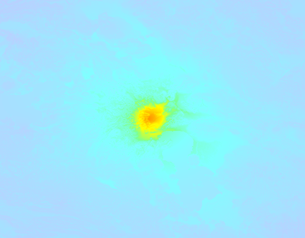
Earthquake Intensity Map
The maximum intensity (MMI Scale) caused by this earthquake is VI. The map below shows in which areas this earthquake was the most and least impactful. It is based on data from the US Geographic Survey.
Shaking reported by 53 people in 5 countries
People that feel an earthquake may report their experience to the US Geographic Survey. Currently, 53 people have reported shaking in 15 places in 5 countries (Egypt, Azerbaijan, Georgia, Iran, Iraq).We keep updating this article as more ground reports become available. You may report that you felt this earthquake here.
Places with most reports:
- Tebriz, Azarbayejān-e Sharqi, Iran: 19 people.
- Khoi, Azarbayejān-e Gharbi, Iran: 11 people.
- Merand, Azarbayejān-e Sharqi, Iran: 5 people.
- Orumiyeh, Azarbayejān-e Gharbi, Iran: 4 people.
- Dilman, Azarbayejān-e Gharbi, Iran: 2 people.
- Azar Shahr, Azarbayejān-e Sharqi, Iran: 2 people.
- Irbīl, Irbīl, Iraq: 2 people.
- El Mansura, ad-Daqahlīyah, Egypt: 1 person.
- Şahbuz, Şahbuz, Azerbaijan: 1 person.
- Tbilisi, Tiflis, Georgia: 1 person.
5 Aftershocks detected
Since this main shock, 5 smaller aftershocks were detected. A 3.4 magnitude earthquake hit 1 day later 35 km (22 mi) east-southeast of this earthquake.
In the days before this main shock, 2 smaller foreshocks were detected. A 3.4 magnitude earthquake hit 3 days earlier nearby.
Overview of foreshocks and aftershocks
| Classification | Magnitude | When | Where |
|---|---|---|---|
| Foreshock | M 3.4 |
3 days earlier Mar 21, 2023 13:29 (Tehran Time) | 37 km (23 mi) E from Main Shock. |
| Foreshock | M 2.5 |
4 hrs earlier Mar 24, 2023 03:35 (Tehran Time) | 35 km (21 mi) NNE from Main Shock. |
| Main Shock This Earthquake |
M 5.6 |
Mar 24, 2023 07:46 (Tehran Time) | - |
| Aftershock | M 3.4 |
15 mins later Mar 24, 2023 08:01 (Tehran Time) | 23 km (15 mi) SE from Main Shock. |
| Aftershock | M 3.2 |
1 hr later Mar 24, 2023 08:57 (Tehran Time) | 55 km (34 mi) SE from Main Shock. |
| Aftershock | M 2.9 |
1 hr later Mar 24, 2023 09:02 (Tehran Time) | 21 km (13 mi) SE from Main Shock. |
| Aftershock | M 3.4 |
1 day later Mar 25, 2023 17:02 (Tehran Time) | 35 km (22 mi) ESE from Main Shock. |
| Aftershock | M 2.7 |
2 days later Mar 26, 2023 04:39 (Tehran Time) | 27 km (17 mi) SSE from Main Shock. |
More earthquakes coming?
Aftershocks are usually at least 1 order of magnitude less strong than main shocks. The more time passes, the smaller the chance and likely strength of any potential aftershocks.
In only six percent of cases, significant earthquakes are followed by a larger main shock, making the current earthquake a foreshock. While the chance of this happening is not so large, it is adviced to maintain cautiousness in the hours and days following a major earthquake.
Read: How to Stay Safe during an Earthquake (cdc.gov).Earthquakes like this are common in the region
Earthquakes of this strength occur quite regularly in the region. This is the strongest earthquake to hit since January 28th, 2023, when a 5.9 magnitude earthquake hit 7 km (4 mi) further east-southeast. An even stronger magnitude 6 earthquake struck on February 23rd, 2020.
In total, 5 earthquakes with a magnitude of 5.6 or higher have been registered within 300km (186 mi) of this epicenter in the past 10 years. This comes down to an average of once every 2 years.
Tsunami very unlikely
While MAG-6.5+ earthquakes may cause tsunami's, it appears that the epicenter of this earthquake hit under land. In addition, the reported depth is deeper than 100km, making the risk of a tsunami even less likely. However always stay cautious and monitor advice from local authorities.
Tsunami Risk Factors
| Factor | Under Sea? | MAG-6.5 or stronger? | Shallow depth? |
|---|---|---|---|
| Explanation | Almost all tsunami's are caused by earthquakes with their epicenter under sea or very near the sea. However stay cautious in coastal areas as earthquakes on land may cause landslides into sea, potentially still causing a local tsunami. | Under MAG 6.5: Very unlikely to cause a tsunami. MAG 6.5 to 7.5: Destructive tsunami's do occur, but are uncommon. Likely to observe small sea level changes. MAG 7.6+: Earthquakes with these magnitudes might produce destructive tsunami's. |
Most destructive tsunami's are caused by shallow earthquakes with a depth between 0 and 100km under the surface of the earth. Deeper tsunami's are unlikely to displace to ocean floor. |
| This Earthquake | Not this earthquake. This earthquake appears to have struck on land far from any coast. |
Not this earthquake. This earthquake had a magnitude of 5.6. Earthquakes of this strength are unlikely to trigger a tsunami. |
This earthquake occurred at a depth of of 17 km (11 mi). Earthquakes this shallow could trigger a tsunami. |
Sources
Last updated 22/05/23 11:37 (). As more information on this earthquake becomes available this article will be updated. This article is automatically composed based on data originating from multiple sources.
- US Geographic Society (USGS): Earthquake us7000jmbi
- European-Mediterranean Seismological Centre (EMSC): Earthquake 20230324_0000029
- Geonames.org: World Cities Database
- Google Maps: Static API
- Earthquakelist.org: Historic Earthquakes Database
Share this article:
