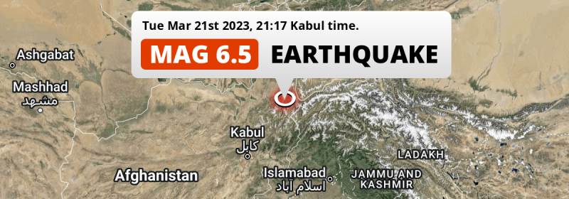
Under land 73 kilometer from Fayzabad in Afghanistan, a strong Magnitude 6.5 earthquake occurred in the evening of Tuesday March 21st, 2023. Shaking may have been felt by a total of 13 million people. Tajikistan and Pakistan are also near its epicenter.
Felt the earthquake? Share this article: 


Earthquake Summary
The earthquake struck on land in Afghanistan, 73 kilometer (45 mi) south-southeast of Fayzabad in Badakhshan. The center of this earthquake had an intermediate depth of 192 km.
| Date and Time: | Mar 21, 2023 21:47 (Dushanbe Time) - Mar 21, 2023 16:47 Universal Time. |
|---|---|
| Location: | 73 km SSE of Fayzabad, Badakhshan, Afghanistan. Coordinates 36°31'23"N 70°56'35"E. |
| Map: | 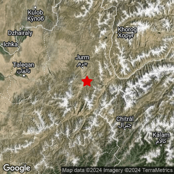 Map of area around epicenter. Click to open in Google Maps. |
| Magnitude: | MAG 6.5 Detected by 30 stations. Maximum Error Range ±0.057 . |
| Depth: | 192 km (119 mi) An intermediate depth. |
| Max. Intensity: | V
Moderate On the Modified Mercalli Scale. |
| Tsunami Risk: | Tsunami very unlikely While a very strong earthquake, it appears to have occurred under land. Always stay cautious - More info here. |
Minimal impact predicted
The US Geographic Survey (USGS) describes the impact of this earthquake as follows:
At least 10 people killed, 80 injured and 665 houses damaged across 9 provinces in Afghanistan. At least 9 people killed, 99 injured, 169 houses and 22 public buildings damaged and power outages occurred in Khyber Pakhtunkhwa, Pakistan. Two people injured at Punjab. Landslides blocked roads near Kalam and Kohistan. One person injured by a collapsed house at Punch, some houses damaged at Rajaori and Srinagar and minor damage to high-rise buildings in Delhi, India. One home damaged at Rudaki, Tajikistan and walls cracked in a high-rise building at Shymkent, Kazakhstan. Shaking felt over an area 1,000 km wide.
Based on scientific estimates by the USGS, the risk of high fatalities for this earthquake is classified at level GREEN (low). They expect an 65% likelyhood of between 0 and 1 fatalities, and a 96% chance that the number of fatalities falls no higher than 10.
The USGS classifies the economic impact of this earthquake at level GREEN (low). They expect an 65% likelyhood of between 0 and 1 million US Dollars in economic damage and impact, and a 96% chance that the economic impact of this earthquake falls no higher than 10 million USD.
Roughly 13 million people exposed to shaking
This earthquake may have been felt by around 13 million people. That is the expected population size of the area exposed to a level of shaking of II or higher on the Modified Mercalli scale according to the USGS.
An estimated 42,110 people were exposed to level V. At this level, moderate shaking and very light damage can be expected. The majority of people (roughly 13 million) live in an area exposed to level IV, where light shaking and likely no damage is expected.
People in 3 countries have been exposed to shaking. In Pakistan , around 5.6 million people, with impact levels up to V (moderate shaking, very light damage). Roughly 5.5 million people were exposed to shaking in Afghanistan . In Tajikistan , around 2.2 million people.
| People | MMI Level | Shaking | Damage |
|---|---|---|---|
| 0 | I |
Not noticable | None |
| 0 | II |
Very weak | None |
| 10 | III |
Weak | Probably none |
| 13,350,000 | IV |
Light | Likely none |
| 42,110 | V |
Moderate | Very light |
| 0 | VI |
Strong | Light |
| 0 | VII |
Very Strong | Moderate |
| 0 | VIII |
Severe | Moderate to heavy |
| 0 | IX |
Violent | Heavy |
| 0 | X |
Extreme | Very heavy |
Nearby towns and cities
This earthquake struck within proximity of multiple countries. Tajikistan , Afghanistan and Pakistan are all within 300km distance of its epicenter. Futher away, this earthquake may also have been felt in Uzbekistan, Kyrgyzstan, India and Turkmenistan.
Located 64 kilometer (40 mi) west-southwest of the epicenter of this earthquake, Ishqoshim (Gorno-Badakhshan, Tajikistan) is the nearest significant population center. The intensity of shaking and damage in Ishqoshim is estimated to be around level IV on the Modified Mercalli Intensity scale (light shaking, likely no damage).
Multiple large cities are in proximity of today's earthquake. Kabul is located 274 km to the southwest (intensity unknown, possibly low). Rawalpindi is located 378 km to the south-southeast (intensity unknown, possibly low). Peshawar is located 286 km to the south-southeast (intensity unknown, possibly low).
A complete list of nearby places is included below. Estimated intensity data (MMI) sourced from a shake-map published by the US Geographic Survey is shown where available (cities without data probably experienced little impact).
Overview of nearby places
| Distance | Place | Intensity (MMI) |
|---|---|---|
| 64 km (40 mi) ENE from epicenter |
Ishqoshim Gorno-Badakhshan, Tajikistan. |
IV
Light |
| 73 km (45 mi) NNW from epicenter |
Fayzabad Badakhshan, Afghanistan. |
IV
Light |
| 120 km (75 mi) NW from epicenter |
Rustāq Takhar, Afghanistan. |
IV
Light |
| 120 km (75 mi) NNE from epicenter |
Khorugh Gorno-Badakhshan, Tajikistan. |
IV
Light |
| 128 km (80 mi) W from epicenter |
Taloqan Takhar, Afghanistan. |
IV
Light |
| 145 km (90 mi) WNW from epicenter |
Ārt Khwājah Takhar, Afghanistan. |
IV
Light |
| 164 km (102 mi) W from epicenter |
Khanabad Kunduz, Afghanistan. |
IV
Light |
| 164 km (102 mi) NW from epicenter |
Chubek Khatlon, Tajikistan. |
IV
Light |
| 165 km (103 mi) SE from epicenter |
Thal Khyber Pakhtunkhwa, Pakistan. |
IV
Light |
| 169 km (105 mi) SSE from epicenter |
Upper Dir Khyber Pakhtunkhwa, Pakistan. |
IV
Light |
| 170 km (106 mi) WSW from epicenter |
Nahrīn Baghlan, Afghanistan. |
IV
Light |
| 170 km (106 mi) SSE from epicenter |
Āsmār Kunar, Afghanistan. |
IV
Light |
| 174 km (108 mi) NW from epicenter |
Farkhor Khatlon, Tajikistan. |
IV
Light |
| 183 km (114 mi) NW from epicenter |
Hulbuk Khatlon, Tajikistan. |
IV
Light |
| 184 km (114 mi) S from epicenter |
Asadābād Kunar, Afghanistan. |
IV
Light |
| 186 km (116 mi) NW from epicenter |
Kŭlob Khatlon, Tajikistan. |
IV
Light |
| 186 km (116 mi) SW from epicenter |
Bāzārak Panjshir, Afghanistan. |
IV
Light |
| 188 km (117 mi) W from epicenter |
Kunduz Kunduz, Afghanistan. |
IV
Light |
| 205 km (127 mi) WSW from epicenter |
Baghlān Baghlan, Afghanistan. |
|
| 207 km (129 mi) WNW from epicenter |
Qarāwul Kunduz, Afghanistan. |
IV
Light |
| 210 km (130 mi) WSW from epicenter |
Pul-e Khumrī Baghlan, Afghanistan. |
|
| 216 km (134 mi) SSW from epicenter |
Mehtar Lām Laghman, Afghanistan. |
|
| 231 km (144 mi) SSE from epicenter |
Bat Khela Khyber Pakhtunkhwa, Pakistan. |
|
| 232 km (144 mi) SW from epicenter |
Charikar Parwan, Afghanistan. |
IV
Light |
| 232 km (144 mi) SE from epicenter |
Mingora Khyber Pakhtunkhwa, Pakistan. |
IV
Light |
| 237 km (147 mi) S from epicenter |
Jalālābād Nangarhar, Afghanistan. |
|
| 241 km (150 mi) NW from epicenter |
Bokhtar Khatlon, Tajikistan. |
IV
Light |
| 262 km (163 mi) SSE from epicenter |
Shabqadar Khyber Pakhtunkhwa, Pakistan. |
|
| 264 km (164 mi) W from epicenter |
Aībak Samangan, Afghanistan. |
|
| 274 km (170 mi) SSE from epicenter |
Charsadda Khyber Pakhtunkhwa, Pakistan. |
|
| 274 km (170 mi) SW from epicenter |
Kabul Kabul, Afghanistan. |
|
| 277 km (172 mi) SSE from epicenter |
Mardan Khyber Pakhtunkhwa, Pakistan. |
|
| 278 km (173 mi) SE from epicenter |
Battagram Khyber Pakhtunkhwa, Pakistan. |
|
| 281 km (175 mi) SW from epicenter |
Paghmān Kabul, Afghanistan. |
|
| 283 km (176 mi) NW from epicenter |
Vahdat Republican Subordination, Tajikistan. |
|
| 286 km (178 mi) SSE from epicenter |
Peshawar Khyber Pakhtunkhwa, Pakistan. |
|
| 290 km (180 mi) W from epicenter |
Khulm Balkh, Afghanistan. |
|
| 294 km (183 mi) NW from epicenter |
Dushanbe Dushanbe, Tajikistan. |
|
| 297 km (185 mi) SSE from epicenter |
Nowshera Cantonment Khyber Pakhtunkhwa, Pakistan. |
|
| 301 km (187 mi) SSE from epicenter |
Swabi Khyber Pakhtunkhwa, Pakistan. |
|
| 307 km (191 mi) SSE from epicenter |
Tordher Khyber Pakhtunkhwa, Pakistan. |
|
| 330 km (205 mi) S from epicenter |
Kohat Khyber Pakhtunkhwa, Pakistan. |
|
| 331 km (206 mi) SE from epicenter |
Muzaffarābād Azad Kashmir, Pakistan. |
|
| 335 km (208 mi) WNW from epicenter |
Tirmiz Surxondaryo, Uzbekistan. |
|
| 335 km (208 mi) SE from epicenter |
Abbottabad Khyber Pakhtunkhwa, Pakistan. |
|
| 337 km (209 mi) SSW from epicenter |
Baraki Barak Logar, Afghanistan. |
|
| 339 km (211 mi) SW from epicenter |
Bāmyān Bamyan, Afghanistan. |
|
| 343 km (213 mi) W from epicenter |
Mazār-e Sharīf Balkh, Afghanistan. |
|
| 361 km (224 mi) SSW from epicenter |
Gardez Paktia, Afghanistan. |
|
| 362 km (225 mi) W from epicenter |
Balkh Balkh, Afghanistan. |
|
| 365 km (227 mi) SSE from epicenter |
Islamabad Islamabad, Pakistan. |
|
| 366 km (227 mi) SSW from epicenter |
Khōst Khowst, Afghanistan. |
|
| 378 km (235 mi) SSE from epicenter |
Rawalpindi Punjab, Pakistan. |
|
| 389 km (242 mi) NNW from epicenter |
Razzakov Batken, Kyrgyzstan. |
|
| 402 km (250 mi) SW from epicenter |
Ghazni Ghazni, Afghanistan. |
|
| 429 km (267 mi) SE from epicenter |
Kotli Azad Kashmir, Pakistan. |
|
| 434 km (270 mi) NNW from epicenter |
Khujand Sughd, Tajikistan. |
|
| 443 km (275 mi) SE from epicenter |
Srinagar Jammu and Kashmir, India. |
|
| 445 km (277 mi) N from epicenter |
Qo‘qon Fergana, Uzbekistan. |
|
| 450 km (280 mi) W from epicenter |
Sar-e Pul Sar-e Pol, Afghanistan. |
|
| 457 km (284 mi) WNW from epicenter |
Gowurdak Lebap, Turkmenistan. |
|
| 458 km (285 mi) NW from epicenter |
Shahrisabz Qashqadaryo, Uzbekistan. |
|
| 464 km (288 mi) W from epicenter |
Shibirghān Jowzjan, Afghanistan. |
|
| 474 km (295 mi) NNE from epicenter |
Osh Osh, Kyrgyzstan. |
|
| 479 km (298 mi) NNW from epicenter |
Guliston Sirdaryo Region, Uzbekistan. |
|
| 484 km (301 mi) NW from epicenter |
Jizzax Jizzax viloyati, Uzbekistan. |
|
| 488 km (303 mi) SE from epicenter |
Bhimber Azad Kashmir, Pakistan. |
|
| 489 km (304 mi) NNE from epicenter |
Andijon Andijon, Uzbekistan. |
|
| 493 km (306 mi) NW from epicenter |
Samarkand Samarqand, Uzbekistan. |
|
| 495 km (308 mi) NNW from epicenter |
Olmaliq Toshkent, Uzbekistan. |
|
| 499 km (310 mi) N from epicenter |
Chust Namangan, Uzbekistan. |
Earthquake Intensity Map
The intensity in shaking and damage by this earthquake is illustrated through the map below. The highest intensity measured for this earthquake is V.

Shaking reported by 562 people in 9 countries
People that feel an earthquake may report their experience to the US Geographic Survey. Currently, 562 people have reported shaking in 189 places in 9 countries (Tajikistan, Turkmenistan, Afghanistan, Uzbekistan, India, Kazakhstan, Kyrgyzstan, Nepal, Pakistan).We keep updating this article as more ground reports become available. You may report that you felt this earthquake here.
Places with most reports:
- Rawalpindi, Punjab, Pakistan: 68 people.
- Lahore, Punjab, Pakistan: 60 people.
- Peshawar, North-West Frontier, Pakistan: 26 people.
- Islamabad, Federal Capital Area, Pakistan: 26 people.
- Gurgaon, Haryana, India: 18 people.
- Noida, Uttar Pradesh, India: 14 people.
- Ghaziabad, Uttar Pradesh, India: 13 people.
- Tashkent, Taschkent, Uzbekistan: 13 people.
- Kāhna, Punjab, Pakistan: 10 people.
- Srīnagar, Jammu and Kashmir, India: 10 people.
Aftershocks detected
Since this main shock, 1 smaller aftershock was detected. At a distance of 30 km (19 mi) south-east of this earthquake, an aftershock struck 2 days later. It measured a magnitude of 4.3
In the days before this main shock, 3 smaller foreshocks were detected. A 4.2 magnitude earthquake hit 9 hrs earlier nearby.
Overview of foreshocks and aftershocks
| Classification | Magnitude | When | Where |
|---|---|---|---|
| Foreshock | M 4.1 |
1 day earlier Mar 20, 2023 07:30PM (Dushanbe Time) | 50 km (31 mi) SE from Main Shock. |
| Foreshock | M 4.2 |
9 hrs earlier Mar 21, 2023 12:25PM (Dushanbe Time) | 11 km (7 mi) S from Main Shock. |
| Foreshock | M 4.0 |
9 hrs earlier Mar 21, 2023 12:25PM (Dushanbe Time) | 47 km (29 mi) N from Main Shock. |
| Main Shock This Earthquake |
M 6.5 |
Mar 21, 2023 09:47PM (Dushanbe Time) | - |
| Aftershock | M 4.3 |
2 days later Mar 23, 2023 12:18PM (Dushanbe Time) | 30 km (19 mi) SE from Main Shock. |
More earthquakes coming?
Aftershocks are usually at least 1 order of magnitude less strong than main shocks. The more time passes, the smaller the chance and likely strength of any potential aftershocks.
In only six percent of cases, significant earthquakes are followed by a larger main shock, making the current earthquake a foreshock. While the chance of this happening is not so large, it is adviced to maintain cautiousness in the hours and days following a major earthquake.
Read: How to Stay Safe during an Earthquake (cdc.gov).Earthquakes like this are common in the region
Earthquakes of this strength occur quite regularly in the region. This is the strongest earthquake to hit since February 23rd, 2023, when a 6.9 magnitude earthquake hit 265 km (164 mi) further north-east. An even stronger magnitude 7.5 earthquake struck on October 26th, 2015.
In total, 4 earthquakes with a magnitude of 6.5 or higher have been registered within 300km (186 mi) of this epicenter in the past 10 years. This comes down to an average of once every 3 years.
Tsunami very unlikely
While MAG-6.5+ earthquakes may cause tsunami's, it appears that the epicenter of this earthquake hit inland, more than 100 km away from coastal areas. In addition, the reported depth is deeper than 100km, making the risk at a tsunami even less likely. However always stay cautious and monitor advice from local authorities.
Tsunami Risk Factors
| Factor | Under Sea? | MAG-6.5 or stronger? | Shallow depth? |
|---|---|---|---|
| Explanation | Almost all tsunami's are caused by earthquakes with their epicenter under sea or very near the sea. However stay cautious in coastal areas as earthquakes on land may cause landslides into sea, potentially still causing a local tsunami. | Under MAG 6.5: Very unlikely to cause a tsunami. MAG 6.5 to 7.5: Destructive tsunami's do occur, but are uncommon. Likely to observe small sea level changes. MAG 7.6+: Earthquakes with these magnitudes might produce destructive tsunami's. |
Most destructive tsunami's are caused by shallow earthquakes with a depth between 0 and 100km under the surface of the earth. Deeper tsunami's are unlikely to displace to ocean floor. |
| This Earthquake | Not this earthquake. This earthquake appears to have struck on land far from any coast. |
This earthquake had a magnitude of 6.5. Earthquakes of this strength could trigger a tsunami. | Not this earthquake. This earthquake occurred at a depth of 192 km (119 mi). Earthquakes this deep in the earth are unlikely to trigger a tsunami. |
Sources
Last updated 20/05/23 10:57 (). As more information on this earthquake becomes available this article will be updated. This article is automatically composed based on data originating from multiple sources.
- US Geographic Society (USGS): Earthquake us7000jln7
- European-Mediterranean Seismological Centre (EMSC): Earthquake 20230321_0000204
- Geonames.org: World Cities Database
- Google Maps: Static API
- Earthquakelist.org: Historic Earthquakes Database
Share this article:
