


Latest earthquakes near Capital Region, Iceland today
Complete overview of the latest earthquakes near Capital Region, Iceland, updated every minute. Did you feel an earthquake today in Capital Region? If an earthquake is happening right now near Capital Region (also known as Höfuðborgarsvæði), it will show up within minutes.
Recent Capital Region Earthquake News
These are the latest articles published related to earthquakes occurring near Capital Region. Check our Earthquake News section for a complete overview of articles written on earthquakes near Capital Region and elsewhere.
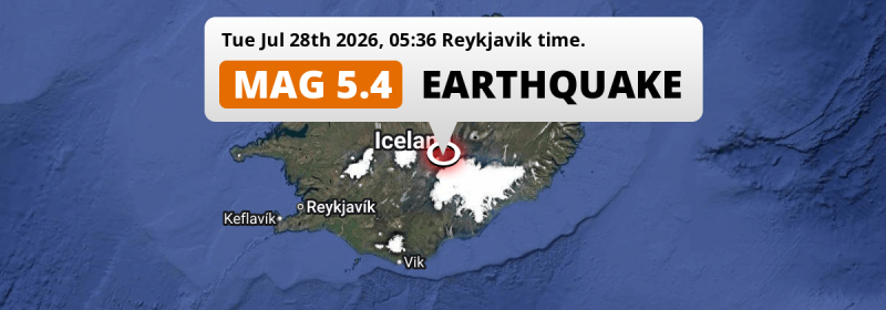
 Jul 28, 2026 05:36AM
On Tuesday Night a Shallow M5.4 Earthquake struck 110km from Akureyri in Iceland.
Jul 28, 2026 05:36AM
On Tuesday Night a Shallow M5.4 Earthquake struck 110km from Akureyri in Iceland.
Capital Region Earthquake Statistics
Average
A total of 399 earthquakes with a magnitude of four or above have struck within 300 km (186 mi) of Capital Region, Iceland in the past 10 years. This comes down to a yearly average of 39 earthquakes per year, or 3 per month. On average an earthquake will hit near Capital Region roughly every 9 days.
A relatively large number of earthquakes occurred near Capital Region in 2023. A total of 105 earthquakes (mag 4+) were detected within 300 km of Capital Region that year. The strongest had a 5.3 magnitude.

Magnitude Distribution
The table below visualizes the distribution of all earthquakes that occurred within 300km of Capital Region in the past 10 years. No earthquakes with a magnitude of 6 or above have occurred near Capital Region during this time. Usually, higher magnitudes are less common than lower magnitudes. Small earthquakes with a magnitude below 4 on the Richter scale have been omitted from this overview.
| Magnitude | Earthquakes | Percentage |
|---|---|---|
| Mag. 4 | 361 | 90.48% |
| Mag. 5 | 37 | 9.27% |
| Mag. 6 | 1 | 0.25% |
| Mag. 7 | 0 | 0.0% |
| Mag. 8 | 0 | 0.0% |
| Mag. 9 | 0 | 0.0% |
| Mag. 10 | 0 | 0.0% |
Strongest earthquakes near Capital Region
The strongest recent earthquake of the past 10 years near Capital Region occurred on Jun 21, 2020 19:07 local time (Atlantic/Reykjavik timezone). It had a magnitude of 6 and struck 290 kilometers (180 mi) north-northeast of Reykjavík, at a depth of 10 km. Discover more strong earthquakes near Capital Region in the list below.
A longer time ago, a MAG-6.9 earthquake struck on Mar 27, 1963 23:15, 251 kilometers (156 mi) north-northeast of Reykjavík. It is the strongest earthquake near Capital Region in the past 126 years (Our data goes back to January 1st, 1900).
In the table below you will find the strongest earthquakes that occurred near Capital Region, Iceland in the past 10 years. You can use the tabs to find the heaviest historic earthquakes since the year 1900 or within a specific year or distance from Capital Region.
Earthquakes by city in Capital Region
Click the links below for earthquake reports for major places in Capital Region, Iceland.
Use this regional Capital Region earthquake report for earthquakes that were felt in smaller towns and cities in the region, including Kópavogur and Hafnarfjörður.
Frequently Asked Questions
These questions are commonly asked in relation to earthquakes occurring near Capital Region.
When was the last earthquake in Capital Region, Iceland?
A 3.4 magnitude earthquake hit near Capital Region on the afternoon of July 28, 2026 at 16:57 local time (Atlantic/Reykjavik). The center of this earthquake was located 160km east of Reykjavík at a depth of 1km under land. Check the list on our website for any earthquakes occurring near Capital Region, Iceland in the past hours.
What was the strongest earthquake near Capital Region, Iceland?
A 6.9 magnitude earthquake hit near Capital Region on the evening of March 27, 1963 at 23:15 local time (Atlantic/Reykjavik). The center of this earthquake was located 251km north-northeast of Reykjavík at a depth of 10km under water in the North Greenland Sea. This is the strongest earthquake that occurred near Capital Region since the year 1900.
How often do earthquakes occur near Capital Region, Iceland?
In the past 10 years, 399 earthquakes with a magnitude of four or higher occurred within a 300 kilometer range from Capital Region. This averages to 40 earthquakes yearly, or one earthquake every 9 days.
