Latest earthquakes near British Columbia, Canada today
Complete overview of the latest earthquakes near British Columbia, Canada, updated every minute. Did you feel an earthquake today in British Columbia? If an earthquake is happening right now near British Columbia, it will show up within minutes.
Recent British Columbia Earthquake News
These are the latest articles published related to earthquakes occurring near British Columbia. Check our Earthquake News section for a complete overview of articles written on earthquakes near British Columbia and elsewhere.
 Jul 19, 2026 11:41PM
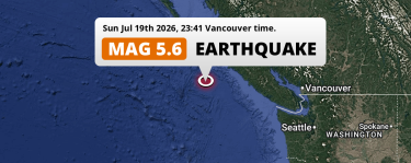
Shallow M5.6 Earthquake hit in the North Pacific Ocean 225km from Vernon Lake (Canada) on Sunday Evening.
Jul 19, 2026 11:41PM
Shallow M5.6 Earthquake hit in the North Pacific Ocean 225km from Vernon Lake (Canada) on Sunday Evening.
British Columbia Earthquake Statistics
Average
A total of 279 earthquakes with a magnitude of four or above have struck within 300 km (186 mi) of British Columbia, Canada in the past 10 years. This comes down to a yearly average of 27 earthquakes per year, or 2 per month. On average an earthquake will hit near British Columbia roughly every 13 days.
A relatively large number of earthquakes occurred near British Columbia in 2024. A total of 57 earthquakes (mag 4+) were detected within 300 km of British Columbia that year. The strongest had a 5.7 magnitude.

Magnitude Distribution
The table below visualizes the distribution of all earthquakes that occurred within 300km of British Columbia in the past 10 years. No earthquakes with a magnitude of 7 or above have occurred near British Columbia during this time. Usually, higher magnitudes are less common than lower magnitudes. Small earthquakes with a magnitude below 4 on the Richter scale have been omitted from this overview.
| Magnitude | Earthquakes | Percentage |
|---|---|---|
| Mag. 4 | 250 | 89.61% |
| Mag. 5 | 25 | 8.96% |
| Mag. 6 | 4 | 1.43% |
| Mag. 7 | 0 | 0.0% |
| Mag. 8 | 0 | 0.0% |
| Mag. 9 | 0 | 0.0% |
| Mag. 10 | 0 | 0.0% |
Strongest earthquakes near British Columbia
The strongest recent earthquake of the past 10 years near British Columbia occurred on Dec 24, 2019 19:36 local time (America/Vancouver timezone). It had a magnitude of 6.3 and struck 264 kilometers (164 mi) west-northwest of Vernon Lake, at a depth of 7 km. Discover more strong earthquakes near British Columbia in the list below.
A longer time ago, a MAG-7.5 earthquake struck on Jun 23, 1946 10:13, 149 kilometers (93 mi) west-northwest of Vancouver. It is the strongest earthquake near British Columbia in the past 126 years (Our data goes back to January 1st, 1900).
In the table below you will find the strongest earthquakes that occurred near British Columbia, Canada in the past 10 years. You can use the tabs to find the heaviest historic earthquakes since the year 1900 or within a specific year or distance from British Columbia.
Earthquakes by city in British Columbia
Click the links below for earthquake reports for major places in British Columbia, Canada.
- Abbotsford
- Burnaby
- Coquitlam
- Cranbrook
- Delta
- Fort St. John
- Kelowna
- Ladner
- Okanagan
- Prince George
- Richmond
- Surrey
- Terrace
- Vancouver
- Vernon Lake
- Victoria
Use this regional British Columbia earthquake report for earthquakes that were felt in smaller towns and cities in the region, including Nanaimo, Kamloops, Maple Ridge, Chilliwack, White Rock, New Westminster, Port Coquitlam, North Vancouver, West End, West Vancouver, Vernon, Langford, Penticton, Campbell River, Mission, North Cowichan, West Kelowna, Port Moody, Walnut Grove, Courtenay and Langley.
Frequently Asked Questions
These questions are commonly asked in relation to earthquakes occurring near British Columbia.
When was the last earthquake in British Columbia, Canada?
A 2.1 magnitude earthquake hit near British Columbia on the afternoon of July 27, 2026 at 16:59 local time (America/Edmonton). The center of this earthquake was located 235km south of Cranbrook at a depth of -1km under land. Check the list on our website for any earthquakes occurring near British Columbia, Canada in the past hours.
What was the strongest earthquake near British Columbia, Canada?
A 7.5 magnitude earthquake hit near British Columbia on the morning of June 23, 1946 at 10:13 local time (America/Vancouver). The center of this earthquake was located 149km west-northwest of Vancouver at a depth of 15km under land. This is the strongest earthquake that occurred near British Columbia since the year 1900.
How often do earthquakes occur near British Columbia, Canada?
In the past 10 years, 279 earthquakes with a magnitude of four or higher occurred within a 300 kilometer range from British Columbia. This averages to 28 earthquakes yearly, or one earthquake every 13 days.
