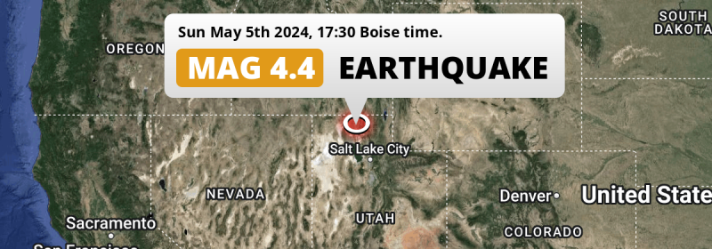
A shallow M4.4 earthquake struck under land 34 miles from Ogden in The United States in the late afternoon of Sunday May 5th, 2024. Shaking may have been felt by a total of 2.1 million people.
Felt the earthquake? Share this article: 


Earthquake Summary
The earthquake struck on land in The United States, 34 miles (54 km) northwest of Ogden in Utah. The center of this earthquake had a very shallow depth of 4 km. Shallow earthquakes usually have a larger impact than earthquakes deep in the earth.
| Date and Time: | May 5, 2024 05:30PM (Denver Time) - May 5, 2024 23:30 Universal Time. |
|---|---|
| Location: | 34 mi NW of Ogden, Utah, The United States. Coordinates 41°34'44"N 112°25'6"W. |
| Map: | 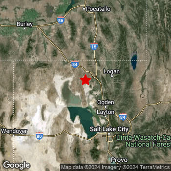 Map of area around epicenter. Click to open in Google Maps. |
| Magnitude: | MAG 4.4 Detected by 33 stations. Maximum Error Range ±0.092 . |
| Depth: | 4 mi (7 km) A very shallow depth. |
| Max. Intensity: | V
Moderate On the Modified Mercalli Scale. |
| Tsunami Risk: | Tsunami very unlikely While this was a shallow earthquake, it appears to have occurred under land with a magnitude not strong enough to cause tsunami's. Always stay cautious - More info here. |
Minimal impact predicted
Based on scientific estimates by the US Geographic Survey (USGS), the risk of high fatalities for this earthquake is classified at level GREEN (low). They expect an 65% likelyhood of between 0 and 1 fatalities, and a 96% chance that the number of fatalities falls no higher than 10.
The USGS classifies the economic impact of this earthquake at level GREEN (low). They expect an 65% likelyhood of between 0 and 1 million US Dollars in economic damage and impact, and a 96% chance that the economic impact of this earthquake falls no higher than 10 million USD.
Roughly 2.1 million people exposed to shaking
This earthquake may have been felt by around 2.1 million people. That is the expected population size of the area exposed to a level of shaking of II or higher on the Modified Mercalli scale according to the USGS.
An estimated 900 people were exposed to level IV. At this level, light shaking and likely no damage can be expected. The majority of people (roughly 1.9 million) live in an area exposed to level II, where very weak shaking and no damage is expected.
| People | MMI Level | Shaking | Damage |
|---|---|---|---|
| 1,130,000 | I |
Not noticable | None |
| 1,910,000 | II |
Very weak | None |
| 216,300 | III |
Weak | Probably none |
| 900 | IV |
Light | Likely none |
| 0 | V |
Moderate | Very light |
| 0 | VI |
Strong | Light |
| 0 | VII |
Very Strong | Moderate |
| 0 | VIII |
Severe | Moderate to heavy |
| 0 | IX |
Violent | Heavy |
| 0 | X |
Extreme | Very heavy |
Nearby towns and cities
This earthquake may have been felt in The United States . The closest significant population center near the earthquake is Brigham City in Utah, The United States. Brigham City is located 21 miles (34 km) west-northwest of the epicenter. Brigham City experienced an earthquake intensity (MMI Scale) of roughly II. That level implies very weak shaking and no damage.
Multiple large cities are in proximity of today's earthquake. Salt Lake City is located 63 mi to the south-southeast and experienced an intensity of II (very weak shaking, no damage). West Valley City is located 65 mi to the south-southeast and experienced an intensity of II (very weak shaking, no damage). West Jordan is located 71 mi to the south-southeast and experienced an intensity of I (not noticeable, no damage).
The table below provides an overview of all places in proximity of today's earthquake. Where available, the estimated intensity on the Modified Mercalli Intensity Scale in each place is included. Places where this information is omitted likely experienced little impact.
Overview of nearby places
| Distance | Place | Intensity (MMI) |
|---|---|---|
| 21 mi (34 km) ESE from epicenter |
Brigham City Utah, The United States. |
II
Weak |
| 30 mi (49 km) SE from epicenter |
North Ogden Utah, The United States. |
III
Weak |
| 32 mi (52 km) ENE from epicenter |
Logan Utah, The United States. |
II
Weak |
| 34 mi (54 km) SE from epicenter |
Ogden Utah, The United States. |
III
Weak |
| 35 mi (57 km) SE from epicenter |
Roy Utah, The United States. |
II
Weak |
| 35 mi (57 km) SE from epicenter |
South Ogden Utah, The United States. |
II
Weak |
| 36 mi (58 km) SSE from epicenter |
Clinton Utah, The United States. |
II
Weak |
| 39 mi (62 km) SSE from epicenter |
Syracuse Utah, The United States. |
II
Weak |
| 39 mi (62 km) SSE from epicenter |
Clearfield Utah, The United States. |
II
Weak |
| 43 mi (69 km) SSE from epicenter |
Layton Utah, The United States. |
II
Weak |
| 45 mi (73 km) SE from epicenter |
Kaysville Utah, The United States. |
II
Weak |
| 50 mi (80 km) SE from epicenter |
Farmington Utah, The United States. |
I
Not felt |
| 54 mi (87 km) SSE from epicenter |
Centerville Utah, The United States. |
II
Weak |
| 55 mi (89 km) SSE from epicenter |
Bountiful Utah, The United States. |
II
Weak |
| 57 mi (92 km) SSE from epicenter |
North Salt Lake Utah, The United States. |
II
Weak |
| 62 mi (100 km) SSE from epicenter |
Magna Utah, The United States. |
II
Weak |
| 63 mi (101 km) SSE from epicenter |
Salt Lake City Utah, The United States. |
II
Weak |
| 65 mi (105 km) SSE from epicenter |
West Valley City Utah, The United States. |
II
Weak |
| 65 mi (105 km) SSE from epicenter |
South Salt Lake Utah, The United States. |
II
Weak |
| 67 mi (108 km) SSE from epicenter |
Kearns Utah, The United States. |
II
Weak |
| 68 mi (109 km) SSE from epicenter |
Taylorsville Utah, The United States. |
II
Weak |
| 68 mi (109 km) SSE from epicenter |
Millcreek Utah, The United States. |
II
Weak |
| 68 mi (110 km) SSE from epicenter |
East Millcreek Utah, The United States. |
II
Weak |
| 69 mi (111 km) SSE from epicenter |
Murray Utah, The United States. |
II
Weak |
| 70 mi (113 km) SSE from epicenter |
Holladay Utah, The United States. |
II
Weak |
| 71 mi (115 km) SSE from epicenter |
West Jordan Utah, The United States. |
I
Not felt |
| 72 mi (116 km) SSE from epicenter |
Midvale Utah, The United States. |
I
Not felt |
| 73 mi (117 km) S from epicenter |
Tooele Utah, The United States. |
I
Not felt |
| 73 mi (118 km) SSE from epicenter |
Cottonwood Heights Utah, The United States. |
I
Not felt |
| 74 mi (119 km) SSE from epicenter |
Sandy Utah, The United States. |
I
Not felt |
| 75 mi (120 km) SSE from epicenter |
South Jordan Heights Utah, The United States. |
II
Weak |
| 75 mi (120 km) SSE from epicenter |
South Jordan Utah, The United States. |
I
Not felt |
| 75 mi (121 km) SSE from epicenter |
Sandy Hills Utah, The United States. |
I
Not felt |
| 76 mi (123 km) SSE from epicenter |
Herriman Utah, The United States. |
I
Not felt |
| 77 mi (124 km) SSE from epicenter |
Riverton Utah, The United States. |
II
Weak |
| 78 mi (126 km) SSE from epicenter |
Draper Utah, The United States. |
I
Not felt |
| 86 mi (139 km) SSE from epicenter |
Highland Utah, The United States. |
I
Not felt |
| 87 mi (140 km) SSE from epicenter |
Lehi Utah, The United States. |
II
Weak |
| 89 mi (143 km) SSE from epicenter |
Saratoga Springs Utah, The United States. |
I
Not felt |
| 89 mi (144 km) SSE from epicenter |
American Fork Utah, The United States. |
I
Not felt |
| 89 mi (144 km) N from epicenter |
Pocatello Idaho, The United States. |
I
Not felt |
| 90 mi (145 km) SSE from epicenter |
Eagle Mountain Utah, The United States. |
I
Not felt |
| 91 mi (147 km) SSE from epicenter |
Pleasant Grove Utah, The United States. |
I
Not felt |
| 96 mi (155 km) SSE from epicenter |
Orem Utah, The United States. |
I
Not felt |
| 101 mi (163 km) SSE from epicenter |
Provo Utah, The United States. |
I
Not felt |
| 106 mi (171 km) SSE from epicenter |
Springville Utah, The United States. |
I
Not felt |
| 109 mi (175 km) SSE from epicenter |
Spanish Fork Utah, The United States. |
I
Not felt |
| 112 mi (180 km) SSE from epicenter |
Payson Utah, The United States. |
I
Not felt |
| 125 mi (201 km) WNW from epicenter |
Twin Falls Idaho, The United States. |
I
Not felt |
| 132 mi (212 km) N from epicenter |
Idaho Falls Idaho, The United States. |
|
| 158 mi (255 km) N from epicenter |
Rexburg Idaho, The United States. |
|
| 166 mi (267 km) E from epicenter |
Rock Springs Wyoming, The United States. |
|
| 181 mi (292 km) WSW from epicenter |
Elko Nevada, The United States. |
Earthquake Intensity Map
The graph below overlays a map of the region around the epicenter with earthquake intensity data provided by the US Geographic Survey. The highest intensity level detected for this earthquake is V.

5 Aftershocks detected
After this earthquake struck, 5 smaller aftershocks occurred. A 3.4 magnitude earthquake hit 2 mins later 1.2 mi (2 km) north-northeast of this earthquake.
Before this earthquake struck, 1 smaller foreshock occurred. Roughly 2 days before this earthquake, a foreshock measuring MAG-3.9 was detected nearby this earthquake.
Overview of foreshocks and aftershocks
| Classification | Magnitude | When | Where |
|---|---|---|---|
| Foreshock | M 3.9 |
2 days earlier May 4, 2024 02:36AM (Denver Time) | 0.1 mi (0.2 km) S from Main Shock. |
| Main Shock This Earthquake |
M 4.4 |
May 5, 2024 05:30PM (Denver Time) | - |
| Aftershock | M 3.4 |
2 mins later May 5, 2024 05:31PM (Denver Time) | 1.2 mi (2 km) NNE from Main Shock. |
| Aftershock | M 2.6 |
1 hr later May 5, 2024 06:35PM (Denver Time) | 1 mi (1.6 km) N from Main Shock. |
| Aftershock | M 3.1 |
1 day later May 6, 2024 11:20PM (Denver Time) | 0.7 mi (1.2 km) NNW from Main Shock. |
| Aftershock | M 2.8 |
2 days later May 7, 2024 05:47AM (Denver Time) | 0.8 mi (1.3 km) NW from Main Shock. |
| Aftershock | M 2.5 |
3 days later May 8, 2024 06:25AM (Denver Time) | 0.9 mi (1.4 km) NNW from Main Shock. |
More earthquakes coming?
Earthquakes can create aftershocks. These are generally at least 1 magnitude lower than any main shock, and as time passes the chance and strength of aftershocks decreases.
It's always adviced to be cautious of the risk of a larger shock following any significant earthquake, however this risk is fairly small. There is a roughly 94 percent change that no larger main shock will follow in the days following this earthquake.
Read: How to Stay Safe during an Earthquake (cdc.gov).This is the strongest earthquake in 3 years
Earthquakes of this strength are very common in the region. This is the strongest earthquake to hit since August 31st, 2021, when a 4.7 magnitude earthquake hit 141 mi (227 km) further west-southwest. An even stronger magnitude 5.7 earthquake struck on March 18th, 2020.
In total, 14 earthquakes with a magnitude of 4.4 or higher have been registered within 300km (186 mi) of this epicenter in the past 10 years. This comes down to an average of once every 9 months.
Tsunami very unlikely
While MAG-6.5+ earthquakes may cause tsunami's, it appears that the epicenter of this earthquake hit under land. In addition, the reported depth is deeper than 100km, making the risk of a tsunami even less likely. However always stay cautious and monitor advice from local authorities.
Tsunami Risk Factors
| Factor | Under Sea? | MAG-6.5 or stronger? | Shallow depth? |
|---|---|---|---|
| Explanation | Almost all tsunami's are caused by earthquakes with their epicenter under sea or very near the sea. However stay cautious in coastal areas as earthquakes on land may cause landslides into sea, potentially still causing a local tsunami. | Under MAG 6.5: Very unlikely to cause a tsunami. MAG 6.5 to 7.5: Destructive tsunami's do occur, but are uncommon. Likely to observe small sea level changes. MAG 7.6+: Earthquakes with these magnitudes might produce destructive tsunami's. |
Most destructive tsunami's are caused by shallow earthquakes with a depth between 0 and 100km under the surface of the earth. Deeper tsunami's are unlikely to displace to ocean floor. |
| This Earthquake | Not this earthquake. This earthquake appears to have struck on land far from any coast. |
Not this earthquake. This earthquake had a magnitude of 4.4. Earthquakes of this strength are unlikely to trigger a tsunami. |
This earthquake occurred at a depth of of 4 mi (7 km). Earthquakes this shallow could trigger a tsunami. |
Sources
Last updated 19/05/24 00:18 (). As more information on this earthquake becomes available this article will be updated. This article is automatically composed based on data originating from multiple sources.
- US Geographic Society (USGS): Earthquake uu80068651
- European-Mediterranean Seismological Centre (EMSC): Earthquake 20240505_0000315
- Geonames.org: World Cities Database
- Google Maps: Static API
- Earthquakelist.org: Historic Earthquakes Database
Share this article:
