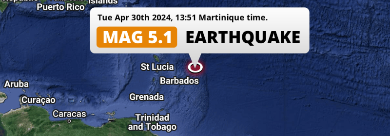
In the early afternoon of Tuesday April 30th, 2024, a shallow and significant MAG-5.1 earthquake hit in the North Atlantic Ocean 152 kilometer from Bridgetown, Barbados. Other countries near the epicenter include Saint Lucia and Martinique.
Felt the earthquake? Share this article: 


Earthquake Summary
This earthquake hit under water in the North Atlantic Ocean, 133 kilometers (83 mi) off the coast of Barbados, 152 kilometer east-northeast of Bridgetown in Saint Michael. The center of this earthquake had a very shallow depth of 10 km. Shallow earthquakes usually have a larger impact than earthquakes deep in the earth.
| Date and Time: | Apr 30, 2024 13:51 (Barbados Time) - Apr 30, 2024 17:51 Universal Time. |
|---|---|
| Location: | 152 km ENE of Bridgetown, Saint Michael, Barbados. Coordinates 13°47'58"N 58°24'39"W. |
| Map: | 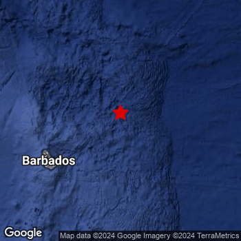 Map of area around epicenter. Click to open in Google Maps. |
| Magnitude: | MAG 5.1 Detected by 20 stations. Maximum Error Range ±0.069 . |
| Depth: | 10 km (6 mi) A very shallow depth. |
| Tsunami Risk: | Low tsunami risk Earthquakes under MAG-6.5 do not usually cause tsunami's. Always stay cautious - More info here. |
Nearby towns and cities
This earthquake struck within proximity of multiple countries. Barbados , Saint Lucia and Martinique are all within 300km distance of its epicenter.
Bridgetown in Saint Michael, Barbados is the nearest significant place from the epicenter. The earthquake occurred 152 kilometer (94 mi) east-northeast of Bridgetown.
An overview of nearby towns and cities is available in the overview below.
Overview of nearby places
| Distance | Place |
|---|---|
| 152 km (94 mi) WSW from epicenter |
Bridgetown Saint Michael, Barbados. |
| 281 km (175 mi) W from epicenter |
Castries Castries, Saint Lucia. |
| 284 km (176 mi) WNW from epicenter |
Le François Martinique, Martinique. |
| 290 km (180 mi) WNW from epicenter |
Le Robert Martinique, Martinique. |
| 290 km (180 mi) WNW from epicenter |
Ducos Martinique, Martinique. |
| 293 km (182 mi) WNW from epicenter |
Le Lamentin Martinique, Martinique. |
| 294 km (183 mi) WNW from epicenter |
La Trinité Martinique, Martinique. |
| 299 km (186 mi) WNW from epicenter |
Sainte-Marie Martinique, Martinique. |
| 299 km (186 mi) WNW from epicenter |
Saint-Joseph Martinique, Martinique. |
Risk of aftershocks?
We have not yet detected any foreshocks or aftershocks (MAG-2.5 or higher) within 100km (62 mi) of this earthquake.
Aftershocks are usually at least 1 order of magnitude less strong than main shocks. The more time passes, the smaller the chance and likely strength of any potential aftershocks.
It's always adviced to be cautious of the risk of a larger shock following any significant earthquake, however this risk is fairly small. There is a roughly 94 percent change that no larger main shock will follow in the days following this earthquake.
Read: How to Stay Safe during an Earthquake (cdc.gov).This is the strongest earthquake in 3 years
Earthquakes of this strength occur quite regularly in the region. This is the strongest earthquake to hit since March 29th, 2021, when a 5.2 magnitude earthquake hit 11 km (7 mi) further northwest. An even stronger magnitude 6.5 earthquake struck on July 16th, 2015.
In total, 7 earthquakes with a magnitude of 5.1 or higher have been registered within 300km (186 mi) of this epicenter in the past 10 years. This comes down to an average of once every year.
Low tsunami risk
Based on early data it appears this earthquake was not strong enough (lower than MAG-6.5) to be likely to cause destructive tsunami's. However this earthquake appeared to have hit at a shallow depth under sea, so stay cautious and monitor advice from local authorities.
Tsunami Risk Factors
| Factor | Under Sea? | MAG-6.5 or stronger? | Shallow depth? |
|---|---|---|---|
| Explanation | Almost all tsunami's are caused by earthquakes with their epicenter under sea or very near the sea. However stay cautious in coastal areas as earthquakes on land may cause landslides into sea, potentially still causing a local tsunami. | Under MAG 6.5: Very unlikely to cause a tsunami. MAG 6.5 to 7.5: Destructive tsunami's do occur, but are uncommon. Likely to observe small sea level changes. MAG 7.6+: Earthquakes with these magnitudes might produce destructive tsunami's. |
Most destructive tsunami's are caused by shallow earthquakes with a depth between 0 and 100km under the surface of the earth. Deeper tsunami's are unlikely to displace to ocean floor. |
| This Earthquake | This earthquake appears to have struck under the sea. | Not this earthquake. This earthquake had a magnitude of 5.1. Earthquakes of this strength are unlikely to trigger a tsunami. |
This earthquake occurred at a depth of of 10 km (6 mi). Earthquakes this shallow could trigger a tsunami. |
Sources
Last updated 20/05/24 01:58 (). This article contains currently available information about the earthquake and is automatically composed. We continue to update this article up to a few days after the earthquake occurred.
- US Geographic Society (USGS): Earthquake us6000mva0
- European-Mediterranean Seismological Centre (EMSC): Earthquake 20240430_0000250
- Geonames.org: World Cities Database
- Google Maps: Static API
- Earthquakelist.org: Historic Earthquakes Database
Share this article:
