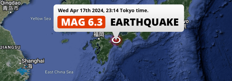
A strong MAG-6.3 earthquake struck in the Philippine Sea 18 kilometer from Uwajima, Japan in the evening of Wednesday April 17th, 2024. Earthquakes like this can cause significant economic damage and have a significant risk at casualties.
Felt the earthquake? Share this article: 


Earthquake Summary
This earthquake hit under water in the Philippine Sea, right off the coast of Japan (4 mi offshore), 18 kilometer west of Uwajima in Ehime. The center of this earthquake had a quite shallow depth of 32 km. Shallow earthquakes usually have a larger impact than earthquakes deep in the earth.
| Date and Time: | Apr 17, 2024 23:14 (Tokyo Time) - Apr 17, 2024 14:14 Universal Time. |
|---|---|
| Location: | 18 km west of Uwajima, Ehime, Japan. Coordinates 33°15'1"N 132°21'53"E. |
| Map: | 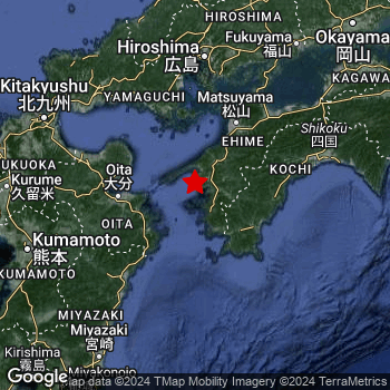 Map of area around epicenter. Click to open in Google Maps. |
| Magnitude: | MAG 6.3 Detected by 69 stations. Maximum Error Range ±0.037 . |
| Depth: | 32 km (20 mi) A quite shallow depth. |
| Max. Intensity: | VIII
Severe On the Modified Mercalli Scale. |
| Tsunami Risk: | Low tsunami risk Earthquakes under MAG-6.5 do not usually cause tsunami's. Always stay cautious - More info here. |
Significant impact predicted
The US Geographic Survey (USGS) describes the impact of this earthquake as follows:
Twelve people injured, nine homes damaged, several buildings damaged and landslides reported in the Ehime-Kochi-Oita area.
Based on scientific estimates by the USGS, the risk of high fatalities for this earthquake is classified at level YELLOW (significant). They expect an 50% likelyhood of between 0 and 1 fatalities, and a 90% chance that the number of fatalities falls no higher than 10.
The USGS classifies the economic impact of this earthquake at level YELLOW (significant). They expect an 36% likelyhood of between 10 and 100 million US Dollars in economic damage and impact, and a 96% chance that the economic impact of this earthquake falls between 1 and 10,000 million USD.
Roughly 20 million people exposed to shaking
An estimated 20 million have been exposed to shaking (An MMI or Modified Mercalli Intensity level II or higher) as a result of this earthquake according scientific estimates published by the USGS.
An estimated 27,740 people were exposed to level VIII. At this level, severe shaking and likely moderate to heavy damage can be expected. The majority of people (roughly 17 million) live in an area exposed to level IV, where light shaking and likely no damage is expected. All exposure to shaking was within the borders of Japan .
| People | MMI Level | Shaking | Damage |
|---|---|---|---|
| 0 | I |
Not noticable | None |
| 0 | II |
Very weak | None |
| 1,884,000 | III |
Weak | Probably none |
| 16,610,000 | IV |
Light | Likely none |
| 1,587,000 | V |
Moderate | Very light |
| 197,800 | VI |
Strong | Light |
| 81,500 | VII |
Very Strong | Moderate |
| 27,740 | VIII |
Severe | Moderate to heavy |
| 0 | IX |
Violent | Heavy |
| 0 | X |
Extreme | Very heavy |
Nearby towns and cities
This earthquake may have been felt in Japan . Uwajima in Ehime, Japan is the nearest significant place from the epicenter. The earthquake occurred 18 kilometer (11 mi) west of Uwajima. The intensity of shaking and damage in Uwajima is estimated to be around level VIII on the Modified Mercalli Intensity scale (severe shaking, likely moderate to heavy damage).
Multiple major population centers exist within 300km of the earthquake that struck today. Busan is located 369 km to the west-northwest (intensity unknown, possibly low). Hiroshima is located 128 km to the north and experienced an intensity of IV (light shaking, likely no damage). Osaka is located 331 km to the east-northeast (intensity unknown, possibly low).
An overview of nearby towns and cities is available in the overview below. If places don't have intensity data available, it likely means the experienced impact in those places was fairly small.
Overview of nearby places
| Distance | Place | Intensity (MMI) |
|---|---|---|
| 18 km (11 mi) E from epicenter |
Uwajima Ehime, Japan. |
VIII
Severe |
| 33 km (21 mi) NNE from epicenter |
Ōzu Ehime, Japan. |
VI
Strong |
| 49 km (30 mi) SE from epicenter |
Sukumo Kōchi, Japan. |
VI
Strong |
| 50 km (31 mi) WSW from epicenter |
Tsukumiura Ōita, Japan. |
VI
Strong |
| 54 km (34 mi) WSW from epicenter |
Usuki Ōita, Japan. |
VI
Strong |
| 55 km (34 mi) SW from epicenter |
Saiki Ōita, Japan. |
VI
Strong |
| 61 km (38 mi) ESE from epicenter |
Nakamura Kōchi, Japan. |
VI
Strong |
| 63 km (39 mi) W from epicenter |
Tsurusaki Ōita, Japan. |
V
Moderate |
| 64 km (40 mi) NNE from epicenter |
Iyo Ehime, Japan. |
V
Moderate |
| 68 km (42 mi) NNE from epicenter |
Masaki-chō Ehime, Japan. |
V
Moderate |
| 71 km (44 mi) W from epicenter |
Ōita Ōita, Japan. |
V
Moderate |
| 72 km (45 mi) WNW from epicenter |
Kitsuki Ōita, Japan. |
V
Moderate |
| 75 km (47 mi) NNE from epicenter |
Matsuyama Ehime, Japan. |
V
Moderate |
| 79 km (49 mi) W from epicenter |
Hiji Ōita, Japan. |
V
Moderate |
| 81 km (50 mi) W from epicenter |
Beppu Ōita, Japan. |
V
Moderate |
| 83 km (52 mi) NNW from epicenter |
Yanai Yamaguchi, Japan. |
IV
Light |
| 87 km (54 mi) NNW from epicenter |
Hikari Yamaguchi, Japan. |
IV
Light |
| 88 km (55 mi) E from epicenter |
Susaki Kōchi, Japan. |
V
Moderate |
| 89 km (55 mi) NNE from epicenter |
Hōjō Ehime, Japan. |
V
Moderate |
| 92 km (57 mi) WNW from epicenter |
Bungo-Takada-shi Ōita, Japan. |
IV
Light |
| 95 km (59 mi) NNW from epicenter |
Kudamatsu Yamaguchi, Japan. |
IV
Light |
| 95 km (59 mi) WSW from epicenter |
Takedamachi Ōita, Japan. |
IV
Light |
| 99 km (62 mi) SW from epicenter |
Nobeoka Miyazaki, Japan. |
IV
Light |
| 102 km (63 mi) NNW from epicenter |
Tokuyama Yamaguchi, Japan. |
IV
Light |
| 102 km (63 mi) N from epicenter |
Iwakuni Yamaguchi, Japan. |
IV
Light |
| 106 km (66 mi) NE from epicenter |
Saijō Ehime, Japan. |
IV
Light |
| 111 km (69 mi) N from epicenter |
Kure Hirochima, Japan. |
IV
Light |
| 113 km (70 mi) ENE from epicenter |
Kochi Kōchi, Japan. |
IV
Light |
| 116 km (72 mi) WNW from epicenter |
Nakatsu Ōita, Japan. |
IV
Light |
| 116 km (72 mi) NW from epicenter |
Hōfu Yamaguchi, Japan. |
IV
Light |
| 118 km (73 mi) NE from epicenter |
Niihama Ehime, Japan. |
IV
Light |
| 122 km (76 mi) N from epicenter |
Hatsukaichi Hirochima, Japan. |
IV
Light |
| 128 km (80 mi) N from epicenter |
Hiroshima Hirochima, Japan. |
IV
Light |
| 129 km (80 mi) NW from epicenter |
Ube Yamaguchi, Japan. |
IV
Light |
| 133 km (83 mi) NW from epicenter |
Yamaguchi Yamaguchi, Japan. |
IV
Light |
| 139 km (86 mi) WNW from epicenter |
Yukuhashi Fukuoka, Japan. |
IV
Light |
| 144 km (89 mi) NNE from epicenter |
Mihara Hirochima, Japan. |
IV
Light |
| 151 km (94 mi) NNE from epicenter |
Onomichi Hirochima, Japan. |
IV
Light |
| 152 km (94 mi) WNW from epicenter |
Shimonoseki Yamaguchi, Japan. |
IV
Light |
| 155 km (96 mi) WNW from epicenter |
Kitakyushu Fukuoka, Japan. |
IV
Light |
| 164 km (102 mi) WSW from epicenter |
Kumamoto Kumamoto, Japan. |
IV
Light |
| 164 km (102 mi) NNW from epicenter |
Masuda Shimane, Japan. |
IV
Light |
| 165 km (103 mi) NE from epicenter |
Fukuyama Hirochima, Japan. |
IV
Light |
| 172 km (107 mi) W from epicenter |
Kurume Fukuoka, Japan. |
IV
Light |
| 173 km (107 mi) SSW from epicenter |
Miyazaki Miyazaki, Japan. |
IV
Light |
| 180 km (112 mi) W from epicenter |
Ōmuta Fukuoka, Japan. |
IV
Light |
| 185 km (115 mi) WNW from epicenter |
Fukuoka Fukuoka, Japan. |
IV
Light |
| 192 km (119 mi) W from epicenter |
Saga Saga, Japan. |
IV
Light |
| 197 km (122 mi) NE from epicenter |
Kurashiki Okayama, Japan. |
IV
Light |
| 197 km (122 mi) NE from epicenter |
Takamatsu Kagawa, Japan. |
IV
Light |
| 212 km (132 mi) NE from epicenter |
Okayama Okayama, Japan. |
III
Weak |
| 223 km (139 mi) ENE from epicenter |
Tokushima Tokushima, Japan. |
|
| 238 km (148 mi) WSW from epicenter |
Nagasaki Nagasaki, Japan. |
|
| 253 km (157 mi) SW from epicenter |
Kagoshima Kagoshima, Japan. |
IV
Light |
| 259 km (161 mi) NNE from epicenter |
Yonago Tottori, Japan. |
|
| 277 km (172 mi) NE from epicenter |
Himeji Hyōgo, Japan. |
|
| 279 km (173 mi) ENE from epicenter |
Minato Wakayama, Japan. |
|
| 331 km (206 mi) ENE from epicenter |
Osaka Ōsaka, Japan. |
|
| 355 km (221 mi) ENE from epicenter |
Nara-shi Nara, Japan. |
|
| 369 km (229 mi) WNW from epicenter |
Busan 부산광역시, South Korea. |
|
| 369 km (229 mi) ENE from epicenter |
Kyoto Kyoto, Japan. |
|
| 375 km (233 mi) ENE from epicenter |
Nabari Mie, Japan. |
|
| 376 km (234 mi) ENE from epicenter |
Ōtsu Shiga, Japan. |
|
| 378 km (235 mi) NW from epicenter |
Ulsan Ulsan, South Korea. |
|
| 389 km (242 mi) NW from epicenter |
Kimhae 경상남도, South Korea. |
|
| 398 km (247 mi) NE from epicenter |
Obama Fukui, Japan. |
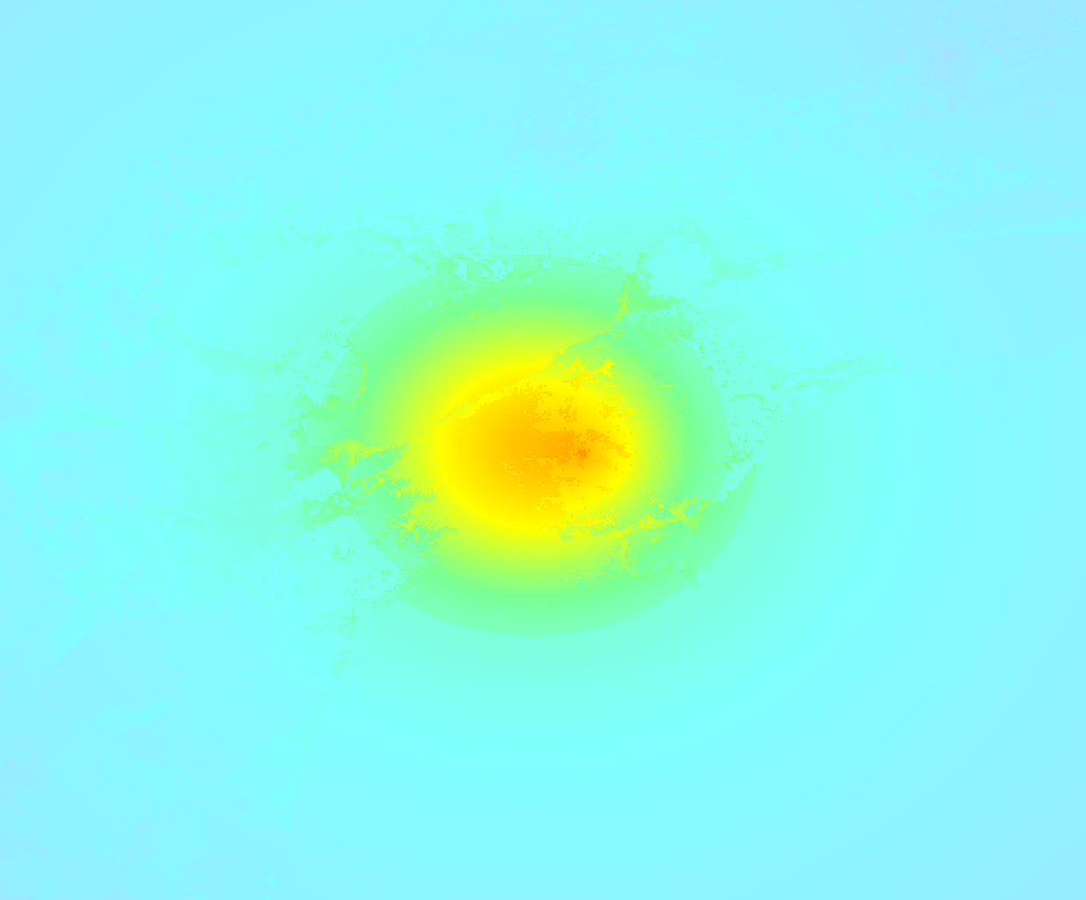
Earthquake Intensity Map
The maximum intensity (MMI Scale) caused by this earthquake is VIII. The map below shows in which areas this earthquake was the most and least impactful. It is based on data from the US Geographic Survey.
Shaking reported by 100 people in 3 countries
People that feel an earthquake may report their experience to the US Geographic Survey. Currently, 100 people have reported shaking in 55 places in 3 countries (Taiwan, Japan, Korea (South)).We keep updating this article as more ground reports become available. You may report that you felt this earthquake here.
Places with most reports:
- Iwakuni, Yamaguchi, Japan: 11 people.
- Uwajima, Ehime, Japan: 7 people.
- Ōsaka, Ōsaka, Japan: 5 people.
- Hiroshima, Hiroshima, Japan: 5 people.
- Pusan, Pusan, Korea (South): 4 people.
- Innoshima, Hiroshima, Japan: 3 people.
- Fuchū (E of Hiroshima), Hiroshima, Japan: 3 people.
- Tamano, Okayama, Japan: 3 people.
- Okayama, Okayama, Japan: 3 people.
- Kurashiki, Okayama, Japan: 3 people.
9 Aftershocks detected
After this earthquake struck, 9 smaller aftershocks occurred. At a distance of 1.1 km (0.7 mi) west-northwest of this earthquake, an aftershock struck 4 mins later. It measured a magnitude of 4.8
Overview of foreshocks and aftershocks
| Classification | Magnitude | When | Where |
|---|---|---|---|
| Main Shock This Earthquake |
M 6.3 |
Apr 17, 2024 23:14 (Tokyo Time) | - |
| Aftershock | M 4.8 |
4 mins later Apr 17, 2024 23:19 (Tokyo Time) | 1.1 km (0.7 mi) WNW from Main Shock. |
| Aftershock | M 4.3 |
13 mins later Apr 17, 2024 23:27 (Tokyo Time) | 8 km (5 mi) SW from Main Shock. |
| Aftershock | M 3.5 |
38 mins later Apr 17, 2024 23:52 (Tokyo Time) | 7 km (4 mi) SSE from Main Shock. |
| Aftershock | M 3.7 |
1 hr later Apr 18, 2024 00:30 (Tokyo Time) | 7 km (4 mi) SSE from Main Shock. |
| Aftershock | M 4.3 |
1 hr later Apr 18, 2024 00:37 (Tokyo Time) | 9 km (6 mi) NNE from Main Shock. |
| Aftershock | M 3.5 |
1 hr later Apr 18, 2024 00:44 (Tokyo Time) | 7 km (4 mi) SSE from Main Shock. |
| Aftershock | M 3.7 |
7 hrs later Apr 18, 2024 06:31 (Tokyo Time) | 7 km (4 mi) SSE from Main Shock. |
| Aftershock | M 3.7 |
13 hrs later Apr 18, 2024 12:16 (Tokyo Time) | 6 km (4 mi) NNE from Main Shock. |
| Aftershock | M 3.8 |
1 day later Apr 18, 2024 23:46 (Tokyo Time) | 7 km (4 mi) SSE from Main Shock. |
More earthquakes coming?
Earthquakes can create aftershocks. These are generally at least 1 magnitude lower than any main shock, and as time passes the chance and strength of aftershocks decreases.
In only six percent of cases, significant earthquakes are followed by a larger main shock, making the current earthquake a foreshock. While the chance of this happening is not so large, it is adviced to maintain cautiousness in the hours and days following a major earthquake.
Read: How to Stay Safe during an Earthquake (cdc.gov).This is an unusually powerful earthquake
Earthquakes of this strength are not so common in the region, but it's not the first time. This is the strongest earthquake to hit since January 21st, 2022, when a 6.3 magnitude earthquake hit 66 km (41 mi) further south-southwest. An even stronger magnitude 7 earthquake struck on April 15th, 2016.
In total, 2 earthquakes with a magnitude of 6.3 or higher have been registered within 300km (186 mi) of this epicenter in the past 10 years. This comes down to an average of once every 5 years.
Low tsunami risk
Based on early data it appears this earthquake was not strong enough (lower than MAG-6.5) to be likely to cause destructive tsunami's. However this earthquake appeared to have hit at a shallow depth under sea, so stay cautious and monitor advice from local authorities.
Tsunami Risk Factors
| Factor | Under Sea? | MAG-6.5 or stronger? | Shallow depth? |
|---|---|---|---|
| Explanation | Almost all tsunami's are caused by earthquakes with their epicenter under sea or very near the sea. However stay cautious in coastal areas as earthquakes on land may cause landslides into sea, potentially still causing a local tsunami. | Under MAG 6.5: Very unlikely to cause a tsunami. MAG 6.5 to 7.5: Destructive tsunami's do occur, but are uncommon. Likely to observe small sea level changes. MAG 7.6+: Earthquakes with these magnitudes might produce destructive tsunami's. |
Most destructive tsunami's are caused by shallow earthquakes with a depth between 0 and 100km under the surface of the earth. Deeper tsunami's are unlikely to displace to ocean floor. |
| This Earthquake | This earthquake appears to have struck under the sea. | Not this earthquake. This earthquake had a magnitude of 6.3. Earthquakes of this strength are unlikely to trigger a tsunami. |
This earthquake occurred at a depth of of 32 km (20 mi). Earthquakes this shallow could trigger a tsunami. |
Sources
Last updated 20/05/24 01:28 (). As more information on this earthquake becomes available this article will be updated. This article is automatically composed based on data originating from multiple sources.
- US Geographic Society (USGS): Earthquake us7000mcpi
- European-Mediterranean Seismological Centre (EMSC): Earthquake 20240417_0000190
- Geonames.org: World Cities Database
- Google Maps: Static API
- Earthquakelist.org: Historic Earthquakes Database
Share this article:
