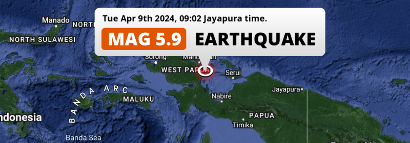
In the morning of Tuesday April 9th, 2024, an unusually powerful Magnitude 5.9 earthquake hit in the South Pacific Ocean 101 kilometer from Manokwari, Indonesia. Shaking may have been felt by a total of 0.8 million people.
Felt the earthquake? Share this article: 


Earthquake Summary
This earthquake hit under water in the South Pacific Ocean, 27 kilometers (17 mi) off the coast of Indonesia, 101 kilometer south-southeast of Manokwari in West Papua. The center of this earthquake had a very shallow depth of 7 km. Shallow earthquakes usually have a larger impact than earthquakes deep in the earth.
| Date and Time: | Apr 9, 2024 09:02 (Jayapura Time) - Apr 9, 2024 00:02 Universal Time. |
|---|---|
| Location: | 101 km SSE of Manokwari, West Papua, Indonesia. Coordinates 1°41'42"S 134°25'25"E. |
| Map: | 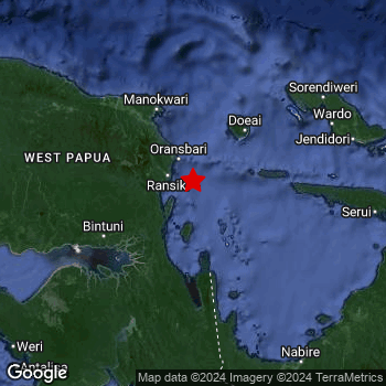 Map of area around epicenter. Click to open in Google Maps. |
| Magnitude: | MAG 5.9 Detected by 32 stations. Maximum Error Range ±0.055 . |
| Depth: | 7 km (4 mi) A very shallow depth. |
| Max. Intensity: | VI
Strong On the Modified Mercalli Scale. |
| Tsunami Risk: | Low tsunami risk Earthquakes under MAG-6.5 do not usually cause tsunami's. Always stay cautious - More info here. |
Minimal impact predicted
Based on scientific estimates by the US Geographic Survey (USGS), the risk of high fatalities for this earthquake is classified at level GREEN (low). They expect an 65% likelyhood of between 0 and 1 fatalities, and a 96% chance that the number of fatalities falls no higher than 10.
The USGS classifies the economic impact of this earthquake at level GREEN (low). They expect an 65% likelyhood of between 0 and 1 million US Dollars in economic damage and impact, and a 96% chance that the economic impact of this earthquake falls no higher than 10 million USD.
Roughly 0.8 million people exposed to shaking
An estimated 0.8 million have been exposed to shaking (An MMI or Modified Mercalli Intensity level II or higher) as a result of this earthquake according scientific estimates published by the USGS.
The highest earthquake impact level for this earthquake is V, which corresponds with moderate shaking and very light damage. Roughly 11,380 people are expected to be exposed to this level. Intensity level III was experienced by the majority of people (around 530 thousand). In their region, weak shaking and probably no damage can be expected. All exposure to shaking was within the borders of Indonesia .
| People | MMI Level | Shaking | Damage |
|---|---|---|---|
| 0 | I |
Not noticable | None |
| 1,390 | II |
Very weak | None |
| 527,500 | III |
Weak | Probably none |
| 267,900 | IV |
Light | Likely none |
| 11,380 | V |
Moderate | Very light |
| 0 | VI |
Strong | Light |
| 0 | VII |
Very Strong | Moderate |
| 0 | VIII |
Severe | Moderate to heavy |
| 0 | IX |
Violent | Heavy |
| 0 | X |
Extreme | Very heavy |
Nearby towns and cities
This earthquake may have been felt in Indonesia . The closest significant population center near the earthquake is Manokwari in West Papua, Indonesia. Manokwari is located 101 kilometer (63 mi) south-southeast of the epicenter. The intensity of shaking and damage in Manokwari is estimated to be around level IV on the Modified Mercalli Intensity scale (light shaking, likely no damage).
Overview of nearby places
| Distance | Place | Intensity (MMI) |
|---|---|---|
| 101 km (63 mi) NNW from epicenter |
Manokwari West Papua, Indonesia. |
IV
Light |
| 220 km (137 mi) SSE from epicenter |
Nabire Papua, Indonesia. |
III
Weak |
| 363 km (226 mi) WNW from epicenter |
Sorong West Papua, Indonesia. |
Earthquake Intensity Map
The graph below overlays a map of the region around the epicenter with earthquake intensity data provided by the US Geographic Survey. The highest intensity level detected for this earthquake is V.

26 Aftershocks detected
This main shock was followed by 26 smaller aftershocks. At a distance of 14 km (9 mi) north-northeast of this earthquake, an aftershock struck 1 min later. It measured a magnitude of 5.5
Overview of foreshocks and aftershocks
| Classification | Magnitude | When | Where |
|---|---|---|---|
| Main Shock This Earthquake |
M 5.9 |
Apr 9, 2024 09:02 (Jayapura Time) | - |
| Aftershock | M 5.5 |
1 min later Apr 9, 2024 09:04 (Jayapura Time) | 14 km (9 mi) NNE from Main Shock. |
| Aftershock | M 3.9 |
14 mins later Apr 9, 2024 09:16 (Jayapura Time) | 28 km (17 mi) NNE from Main Shock. |
| Aftershock | M 2.7 |
27 mins later Apr 9, 2024 09:30 (Jayapura Time) | 45 km (28 mi) NNE from Main Shock. |
| Aftershock | M 3.7 |
4 hrs later Apr 9, 2024 12:43 (Jayapura Time) | 25 km (16 mi) NNE from Main Shock. |
| Aftershock | M 4.3 |
4 hrs later Apr 9, 2024 13:29 (Jayapura Time) | 28 km (17 mi) NE from Main Shock. |
| Aftershock | M 4.0 |
4 hrs later Apr 9, 2024 13:29 (Jayapura Time) | 9 km (6 mi) WNW from Main Shock. |
| Aftershock | M 4.8 |
5 hrs later Apr 9, 2024 14:14 (Jayapura Time) | 13 km (8 mi) ENE from Main Shock. |
| Aftershock | M 3.3 |
10 hrs later Apr 9, 2024 18:40 (Jayapura Time) | 31 km (19 mi) NE from Main Shock. |
| Aftershock | M 3.5 |
11 hrs later Apr 9, 2024 20:05 (Jayapura Time) | 31 km (19 mi) NE from Main Shock. |
| Aftershock | M 4.4 |
11 hrs later Apr 9, 2024 20:10 (Jayapura Time) | 25 km (15 mi) NE from Main Shock. |
| Aftershock | M 2.5 |
12 hrs later Apr 9, 2024 21:32 (Jayapura Time) | 43 km (27 mi) NE from Main Shock. |
| Aftershock | M 4.0 |
15 hrs later Apr 10, 2024 00:20 (Jayapura Time) | 28 km (17 mi) NE from Main Shock. |
| Aftershock | M 2.6 |
16 hrs later Apr 10, 2024 01:04 (Jayapura Time) | 25 km (16 mi) N from Main Shock. |
| Aftershock | M 3.0 |
17 hrs later Apr 10, 2024 02:16 (Jayapura Time) | 28 km (18 mi) NNE from Main Shock. |
| Aftershock | M 3.0 |
17 hrs later Apr 10, 2024 02:21 (Jayapura Time) | 23 km (15 mi) NNE from Main Shock. |
| Aftershock | M 4.0 |
22 hrs later Apr 10, 2024 07:22 (Jayapura Time) | 29 km (18 mi) NE from Main Shock. |
| Aftershock | M 3.6 |
22 hrs later Apr 10, 2024 07:25 (Jayapura Time) | 23 km (14 mi) N from Main Shock. |
| Aftershock | M 3.1 |
23 hrs later Apr 10, 2024 08:26 (Jayapura Time) | 32 km (20 mi) N from Main Shock. |
| Aftershock | M 3.0 |
1 day later Apr 10, 2024 11:28 (Jayapura Time) | 22 km (13 mi) NNE from Main Shock. |
| Aftershock | M 4.2 |
1 day later Apr 10, 2024 12:08 (Jayapura Time) | 25 km (15 mi) NE from Main Shock. |
| Aftershock | M 4.0 |
1 day later Apr 10, 2024 12:08 (Jayapura Time) | 20 km (12 mi) ESE from Main Shock. |
| Aftershock | M 3.6 |
1 day later Apr 10, 2024 12:25 (Jayapura Time) | 24 km (15 mi) NNE from Main Shock. |
| Aftershock | M 3.2 |
2 days later Apr 10, 2024 22:13 (Jayapura Time) | 62 km (39 mi) NE from Main Shock. |
| Aftershock | M 2.7 |
2 days later Apr 11, 2024 04:13 (Jayapura Time) | 36 km (22 mi) NNE from Main Shock. |
| Aftershock | M 2.8 |
2 days later Apr 11, 2024 20:24 (Jayapura Time) | 28 km (17 mi) NE from Main Shock. |
| Aftershock | M 3.3 |
2 days later Apr 11, 2024 20:41 (Jayapura Time) | 22 km (13 mi) NE from Main Shock. |
More earthquakes coming?
Aftershocks are usually at least 1 order of magnitude less strong than main shocks. The more time passes, the smaller the chance and likely strength of any potential aftershocks.
The chance that a significant earthquake like this one is followed by an even larger earthquake is not so large. On average, scientists estimate a 94% chance that a major earthquake will not be followed by an even larger one. It is still adviced to be aware of this risk
Read: How to Stay Safe during an Earthquake (cdc.gov).This is an unusually powerful earthquake
Earthquakes of this strength are not so common in the region, but it's not the first time. This is the strongest earthquake to hit since November 10th, 2021, when a 6 magnitude earthquake hit 294 km (182 mi) further south. That was also the heaviest earthquake to hit the region in the past 10 years.
In total, 1 earthquake with a magnitude of 5.9 or higher have been registered within 300km (186 mi) of this epicenter in the past 10 years. This comes down to an average of once every 10 years.
Low tsunami risk
Based on early data it appears this earthquake was not strong enough (lower than MAG-6.5) to be likely to cause destructive tsunami's. However this earthquake appeared to have hit at a shallow depth under sea, so stay cautious and monitor advice from local authorities.
Tsunami Risk Factors
| Factor | Under Sea? | MAG-6.5 or stronger? | Shallow depth? |
|---|---|---|---|
| Explanation | Almost all tsunami's are caused by earthquakes with their epicenter under sea or very near the sea. However stay cautious in coastal areas as earthquakes on land may cause landslides into sea, potentially still causing a local tsunami. | Under MAG 6.5: Very unlikely to cause a tsunami. MAG 6.5 to 7.5: Destructive tsunami's do occur, but are uncommon. Likely to observe small sea level changes. MAG 7.6+: Earthquakes with these magnitudes might produce destructive tsunami's. |
Most destructive tsunami's are caused by shallow earthquakes with a depth between 0 and 100km under the surface of the earth. Deeper tsunami's are unlikely to displace to ocean floor. |
| This Earthquake | This earthquake appears to have struck under the sea. | Not this earthquake. This earthquake had a magnitude of 5.9. Earthquakes of this strength are unlikely to trigger a tsunami. |
This earthquake occurred at a depth of of 7 km (4 mi). Earthquakes this shallow could trigger a tsunami. |
Sources
Last updated 20/05/24 02:58 (). This article contains currently available information about the earthquake and is automatically composed. We continue to update this article up to a few days after the earthquake occurred.
- US Geographic Society (USGS): Earthquake us7000maw0
- European-Mediterranean Seismological Centre (EMSC): Earthquake 20240409_0000002
- Geonames.org: World Cities Database
- Google Maps: Static API
- Earthquakelist.org: Historic Earthquakes Database
Share this article:
