In the Java Sea 159 kilometer from Surabaya, Indonesia, a shallow and strong Magnitude 6.4 earthquake occurred in the afternoon of Friday March 22nd, 2024. Earthquakes like this can cause significant economic damage and have a significant risk at casualties.
Felt the earthquake? Share this article: 


Earthquake Summary
This earthquake hit under water in the Java Sea, 25 kilometers (16 mi) off the coast of Indonesia, 159 kilometer north-northwest of Surabaya in East Java. The center of this earthquake had a very shallow depth of 9 km. Shallow earthquakes usually have a larger impact than earthquakes deep in the earth.
| Date and Time: | Mar 22, 2024 15:52 (Jakarta Time) - Mar 22, 2024 08:52 Universal Time. |
|---|---|
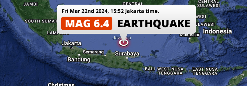
| Location: | 159 km NNW of Surabaya, East Java, Indonesia. Coordinates 5°52'32"S 112°21'58"E. |
| Map: |  Map of area around epicenter. Click to open in Google Maps. |
| Magnitude: | MAG 6.4 Detected by 65 stations. Maximum Error Range ±0.038 . |
| Depth: | 9 km (6 mi) A very shallow depth. |
| Max. Intensity: | VIII
Severe On the Modified Mercalli Scale. |
| Tsunami Risk: | Low tsunami risk Earthquakes under MAG-6.5 do not usually cause tsunami's. Always stay cautious - More info here. |
Significant impact predicted
The US Geographic Survey (USGS) describes the impact of this earthquake as follows:
Five persons injured, 774 homes destoyred, 4982 buildings damaged in the Bawean-Surabaya-Tuban region.
Based on scientific estimates by the USGS, the risk of high fatalities for this earthquake is classified at level YELLOW (significant). They expect an 50% likelyhood of between 0 and 1 fatalities, and a 99% chance that the number of fatalities falls no higher than 100.
The USGS classifies the economic impact of this earthquake at level YELLOW (significant). They expect an 48% likelyhood of between 0 and 1 million US Dollars in economic damage and impact, and a 99% chance that the economic impact of this earthquake falls no higher than 100 million USD.
Roughly 33 million people exposed to shaking
An estimated 33 million have been exposed to shaking (An MMI or Modified Mercalli Intensity level II or higher) as a result of this earthquake according scientific estimates published by the USGS.
Severe shaking and likely moderate to heavy damage may have been experienced by an estimated 1,690 people. At VIII, it is the highest MMI level this earthquake has caused. Intensity level IV was experienced by the majority of people (around 29 million). In their region, light shaking and likely no damage can be expected. All exposure to shaking was within the borders of Indonesia .
| People | MMI Level | Shaking | Damage |
|---|---|---|---|
| 0 | I |
Not noticable | None |
| 0 | II |
Very weak | None |
| 2,782,000 | III |
Weak | Probably none |
| 28,730,000 | IV |
Light | Likely none |
| 1,627,000 | V |
Moderate | Very light |
| 10,140 | VI |
Strong | Light |
| 26,830 | VII |
Very Strong | Moderate |
| 1,690 | VIII |
Severe | Moderate to heavy |
| 0 | IX |
Violent | Heavy |
| 0 | X |
Extreme | Very heavy |
Nearby towns and cities
This earthquake may have been felt in Indonesia . Located 111 kilometer (69 mi) north of the epicenter of this earthquake, Paciran (East Java, Indonesia) is the nearest significant population center. The intensity of shaking and damage in Paciran is estimated to be around level IV on the Modified Mercalli Intensity scale (light shaking, likely no damage).
Major cities near this earthquake: Surabaya is located 159 km to the south-southeast and experienced an intensity of V (moderate shaking, very light damage). Semarang is located 248 km to the west-southwest (intensity unknown, possibly low). Malang is located 236 km to the south (intensity unknown, possibly low).
A complete list of nearby places is included below. Estimated intensity data (MMI) sourced from a shake-map published by the US Geographic Survey is shown where available (cities without data probably experienced little impact).
Overview of nearby places
| Distance | Place | Intensity (MMI) |
|---|---|---|
| 111 km (69 mi) S from epicenter |
Paciran East Java, Indonesia. |
IV
Light |
| 118 km (73 mi) SSW from epicenter |
Tuban East Java, Indonesia. |
IV
Light |
| 136 km (85 mi) SW from epicenter |
Lasem Central Java, Indonesia. |
IV
Light |
| 136 km (85 mi) SSE from epicenter |
Bangkalan East Java, Indonesia. |
IV
Light |
| 138 km (86 mi) S from epicenter |
Lamongan East Java, Indonesia. |
IV
Light |
| 139 km (86 mi) S from epicenter |
Babat East Java, Indonesia. |
IV
Light |
| 146 km (91 mi) SW from epicenter |
Rembangan Central Java, Indonesia. |
IV
Light |
| 146 km (91 mi) SSE from epicenter |
Gresik East Java, Indonesia. |
IV
Light |
| 147 km (91 mi) SSE from epicenter |
Kebomas East Java, Indonesia. |
IV
Light |
| 149 km (93 mi) SSE from epicenter |
Kamal East Java, Indonesia. |
IV
Light |
| 151 km (94 mi) SSW from epicenter |
Bojonegoro East Java, Indonesia. |
IV
Light |
| 159 km (99 mi) SSE from epicenter |
Surabaya East Java, Indonesia. |
V
Moderate |
| 161 km (100 mi) SW from epicenter |
Blora Central Java, Indonesia. |
IV
Light |
| 163 km (101 mi) WSW from epicenter |
Tayu Central Java, Indonesia. |
IV
Light |
| 164 km (102 mi) SW from epicenter |
Juwana Central Java, Indonesia. |
IV
Light |
| 165 km (103 mi) SSW from epicenter |
Cepu Central Java, Indonesia. |
IV
Light |
| 172 km (107 mi) S from epicenter |
Krian East Java, Indonesia. |
IV
Light |
| 173 km (107 mi) SSE from epicenter |
Gedangan East Java, Indonesia. |
IV
Light |
| 175 km (109 mi) SE from epicenter |
Sampang East Java, Indonesia. |
IV
Light |
| 176 km (109 mi) SW from epicenter |
Pati Central Java, Indonesia. |
IV
Light |
| 177 km (110 mi) S from epicenter |
Mojokerto East Java, Indonesia. |
IV
Light |
| 177 km (110 mi) SSE from epicenter |
Buduran East Java, Indonesia. |
IV
Light |
| 179 km (111 mi) SSE from epicenter |
Sidoarjo East Java, Indonesia. |
IV
Light |
| 180 km (112 mi) S from epicenter |
Tulangan Utara East Java, Indonesia. |
IV
Light |
| 184 km (114 mi) SSE from epicenter |
Tanggulangin East Java, Indonesia. |
IV
Light |
| 186 km (116 mi) S from epicenter |
Jombang East Java, Indonesia. |
IV
Light |
| 188 km (117 mi) SE from epicenter |
Pamekasan East Java, Indonesia. |
IV
Light |
| 190 km (118 mi) S from epicenter |
Diwek East Java, Indonesia. |
IV
Light |
| 190 km (118 mi) SW from epicenter |
Jekulo Central Java, Indonesia. |
IV
Light |
| 192 km (119 mi) S from epicenter |
Kertosono East Java, Indonesia. |
IV
Light |
| 193 km (120 mi) WSW from epicenter |
Gebog Central Java, Indonesia. |
IV
Light |
| 194 km (121 mi) WSW from epicenter |
Baekrajan Central Java, Indonesia. |
IV
Light |
| 195 km (121 mi) WSW from epicenter |
Batang Central Java, Indonesia. |
IV
Light |
| 198 km (123 mi) WSW from epicenter |
Kudus Central Java, Indonesia. |
IV
Light |
| 198 km (123 mi) SSE from epicenter |
Bangil East Java, Indonesia. |
IV
Light |
| 199 km (124 mi) SSW from epicenter |
Nganjuk East Java, Indonesia. |
IV
Light |
| 206 km (128 mi) SSE from epicenter |
Pasuruan East Java, Indonesia. |
IV
Light |
| 209 km (130 mi) SW from epicenter |
Purwodadi Central Java, Indonesia. |
IV
Light |
| 216 km (134 mi) SSW from epicenter |
Madiun East Java, Indonesia. |
IV
Light |
| 219 km (136 mi) S from epicenter |
Kediri East Java, Indonesia. |
|
| 221 km (137 mi) S from epicenter |
Lawang East Java, Indonesia. |
|
| 229 km (142 mi) SSE from epicenter |
Probolinggo East Java, Indonesia. |
|
| 236 km (147 mi) S from epicenter |
Malang East Java, Indonesia. |
|
| 248 km (154 mi) WSW from epicenter |
Semarang Central Java, Indonesia. |
|
| 248 km (154 mi) S from epicenter |
Blitar East Java, Indonesia. |
|
| 252 km (157 mi) SW from epicenter |
Surakarta Central Java, Indonesia. |
IV
Light |
| 263 km (163 mi) SW from epicenter |
Salatiga Central Java, Indonesia. |
|
| 273 km (170 mi) SE from epicenter |
Situbondo East Java, Indonesia. |
|
| 295 km (183 mi) SSE from epicenter |
Jember East Java, Indonesia. |
|
| 308 km (191 mi) SW from epicenter |
Yogyakarta Yogyakarta, Indonesia. |
|
| 376 km (234 mi) NE from epicenter |
Banjarmasin South Kalimantan, Indonesia. |
|
| 377 km (234 mi) N from epicenter |
Sampit Central Kalimantan, Indonesia. |
|
| 390 km (242 mi) SE from epicenter |
Singaraja Bali, Indonesia. |
Earthquake Intensity Map
The graph below overlays a map of the region around the epicenter with earthquake intensity data provided by the US Geographic Survey. The highest intensity level detected for this earthquake is VIII.

Shaking reported by 97 people
People that feel an earthquake may report their experience to the US Geographic Survey. Currently, 97 people have reported shaking in 40 places, all within Indonesia.We keep updating this article as more ground reports become available. You may report that you felt this earthquake here.
Places with most reports:
- Surabaya, Jawa Timur, Indonesia: 30 people.
- Gedangan, Jawa Timur, Indonesia: 10 people.
- Jakarta, Jakarta, Indonesia: 6 people.
- Semarang, Jawa Tengah, Indonesia: 3 people.
- Banjarmasin, Kalimantan Selatan, Indonesia: 3 people.
- Malang, Jawa Timur, Indonesia: 3 people.
- Driyorejo, Jawa Timur, Indonesia: 2 people.
- Bandung, Jawa Barat, Indonesia: 2 people.
- Bekasi, Jawa Barat, Indonesia: 2 people.
- Pamanukan, Jawa Barat, Indonesia: 2 people.
59 Aftershocks detected
After this earthquake struck, 59 smaller aftershocks occurred. Just 26 mins after this main shock, an earthquake measuring MAG-4.7 was detected 10 km (6 mi) east of this earthquake.
Before this earthquake struck, 10 smaller foreshocks occurred. Roughly 5 hrs before this earthquake, a foreshock measuring MAG-5.6 was detected nearby this earthquake.
Overview of foreshocks and aftershocks
| Classification | Magnitude | When | Where |
|---|---|---|---|
| Foreshock | M 5.6 |
5 hrs earlier Mar 22, 2024 11:22 (Jakarta Time) | 8 km (5 mi) NW from Main Shock. |
| Foreshock | M 3.3 |
4 hrs earlier Mar 22, 2024 11:56 (Jakarta Time) | 16 km (10 mi) N from Main Shock. |
| Foreshock | M 5.2 |
3 hrs earlier Mar 22, 2024 12:31 (Jakarta Time) | 4 km (2.5 mi) SSE from Main Shock. |
| Foreshock | M 3.9 |
3 hrs earlier Mar 22, 2024 12:37 (Jakarta Time) | 19 km (12 mi) NNW from Main Shock. |
| Foreshock | M 3.5 |
3 hrs earlier Mar 22, 2024 12:40 (Jakarta Time) | 9 km (6 mi) NNW from Main Shock. |
| Foreshock | M 3.2 |
3 hrs earlier Mar 22, 2024 12:44 (Jakarta Time) | 21 km (13 mi) N from Main Shock. |
| Foreshock | M 3.9 |
3 hrs earlier Mar 22, 2024 13:05 (Jakarta Time) | 11 km (7 mi) N from Main Shock. |
| Foreshock | M 3.5 |
3 hrs earlier Mar 22, 2024 13:18 (Jakarta Time) | 13 km (8 mi) N from Main Shock. |
| Foreshock | M 3.6 |
2 hrs earlier Mar 22, 2024 13:53 (Jakarta Time) | 8 km (5 mi) WNW from Main Shock. |
| Foreshock | M 3.5 |
34 mins earlier Mar 22, 2024 15:19 (Jakarta Time) | 0.8 km (0.5 mi) NE from Main Shock. |
| Main Shock This Earthquake |
M 6.4 |
Mar 22, 2024 15:52 (Jakarta Time) | - |
| Aftershock | M 4.4 |
20 mins later Mar 22, 2024 16:12 (Jakarta Time) | 22 km (13 mi) NNE from Main Shock. |
| Aftershock | M 4.7 |
26 mins later Mar 22, 2024 16:19 (Jakarta Time) | 10 km (6 mi) E from Main Shock. |
| Aftershock | M 3.6 |
35 mins later Mar 22, 2024 16:28 (Jakarta Time) | 32 km (20 mi) SW from Main Shock. |
| Aftershock | M 3.5 |
39 mins later Mar 22, 2024 16:31 (Jakarta Time) | 25 km (16 mi) NNW from Main Shock. |
| Aftershock | M 3.7 |
44 mins later Mar 22, 2024 16:37 (Jakarta Time) | 13 km (8 mi) NNW from Main Shock. |
| Aftershock | M 4.6 |
1 hr later Mar 22, 2024 16:55 (Jakarta Time) | 4 km (2.4 mi) E from Main Shock. |
| Aftershock | M 3.7 |
1 hr later Mar 22, 2024 17:15 (Jakarta Time) | 10 km (6 mi) NNE from Main Shock. |
| Aftershock | M 3.7 |
1 hr later Mar 22, 2024 17:16 (Jakarta Time) | 12 km (7 mi) NW from Main Shock. |
| Aftershock | M 4.0 |
2 hrs later Mar 22, 2024 17:26 (Jakarta Time) | 13 km (8 mi) NNE from Main Shock. |
| Aftershock | M 3.6 |
2 hrs later Mar 22, 2024 17:29 (Jakarta Time) | 9 km (6 mi) E from Main Shock. |
| Aftershock | M 3.5 |
2 hrs later Mar 22, 2024 17:34 (Jakarta Time) | 8 km (5 mi) WSW from Main Shock. |
| Aftershock | M 3.6 |
2 hrs later Mar 22, 2024 17:36 (Jakarta Time) | 5 km (3 mi) NNW from Main Shock. |
| Aftershock | M 3.5 |
2 hrs later Mar 22, 2024 17:40 (Jakarta Time) | 14 km (9 mi) N from Main Shock. |
| Aftershock | M 4.0 |
2 hrs later Mar 22, 2024 17:54 (Jakarta Time) | 22 km (14 mi) N from Main Shock. |
| Aftershock | M 4.5 |
2 hrs later Mar 22, 2024 17:57 (Jakarta Time) | 7 km (4 mi) N from Main Shock. |
| Aftershock | M 3.5 |
2 hrs later Mar 22, 2024 18:17 (Jakarta Time) | 6 km (4 mi) WNW from Main Shock. |
| Aftershock | M 3.4 |
3 hrs later Mar 22, 2024 18:30 (Jakarta Time) | 12 km (7 mi) E from Main Shock. |
| Aftershock | M 3.5 |
3 hrs later Mar 22, 2024 18:40 (Jakarta Time) | 20 km (12 mi) S from Main Shock. |
| Aftershock | M 3.7 |
3 hrs later Mar 22, 2024 18:43 (Jakarta Time) | 8 km (5 mi) NNW from Main Shock. |
| Aftershock | M 3.3 |
3 hrs later Mar 22, 2024 19:15 (Jakarta Time) | 13 km (8 mi) WNW from Main Shock. |
| Aftershock | M 3.4 |
3 hrs later Mar 22, 2024 19:22 (Jakarta Time) | 11 km (7 mi) SE from Main Shock. |
| Aftershock | M 3.6 |
4 hrs later Mar 22, 2024 19:39 (Jakarta Time) | 11 km (7 mi) WNW from Main Shock. |
| Aftershock | M 3.3 |
4 hrs later Mar 22, 2024 19:58 (Jakarta Time) | 9 km (5 mi) N from Main Shock. |
| Aftershock | M 3.4 |
4 hrs later Mar 22, 2024 20:03 (Jakarta Time) | 7 km (4 mi) SSW from Main Shock. |
| Aftershock | M 3.3 |
5 hrs later Mar 22, 2024 21:19 (Jakarta Time) | 25 km (16 mi) NE from Main Shock. |
| Aftershock | M 3.7 |
7 hrs later Mar 22, 2024 22:24 (Jakarta Time) | 7 km (5 mi) NNW from Main Shock. |
| Aftershock | M 3.4 |
7 hrs later Mar 22, 2024 22:37 (Jakarta Time) | 15 km (9 mi) W from Main Shock. |
| Aftershock | M 3.0 |
7 hrs later Mar 22, 2024 22:47 (Jakarta Time) | 4 km (2.7 mi) NNW from Main Shock. |
| Aftershock | M 4.1 |
7 hrs later Mar 22, 2024 23:12 (Jakarta Time) | 14 km (8 mi) NW from Main Shock. |
| Aftershock | M 3.0 |
8 hrs later Mar 23, 2024 00:05 (Jakarta Time) | 17 km (11 mi) NNW from Main Shock. |
| Aftershock | M 3.3 |
8 hrs later Mar 23, 2024 00:12 (Jakarta Time) | 0.9 km (0.6 mi) NW from Main Shock. |
| Aftershock | M 3.7 |
9 hrs later Mar 23, 2024 00:25 (Jakarta Time) | 18 km (11 mi) NNW from Main Shock. |
| Aftershock | M 3.3 |
9 hrs later Mar 23, 2024 00:52 (Jakarta Time) | 4 km (2.7 mi) WSW from Main Shock. |
| Aftershock | M 3.1 |
9 hrs later Mar 23, 2024 00:58 (Jakarta Time) | 15 km (10 mi) N from Main Shock. |
| Aftershock | M 3.3 |
10 hrs later Mar 23, 2024 01:46 (Jakarta Time) | 25 km (16 mi) N from Main Shock. |
| Aftershock | M 3.7 |
10 hrs later Mar 23, 2024 01:58 (Jakarta Time) | 18 km (11 mi) NNE from Main Shock. |
| Aftershock | M 3.5 |
10 hrs later Mar 23, 2024 02:20 (Jakarta Time) | 8 km (5 mi) SSW from Main Shock. |
| Aftershock | M 3.6 |
11 hrs later Mar 23, 2024 03:10 (Jakarta Time) | 30 km (18 mi) NNE from Main Shock. |
| Aftershock | M 3.6 |
12 hrs later Mar 23, 2024 03:28 (Jakarta Time) | 13 km (8 mi) NW from Main Shock. |
| Aftershock | M 4.5 |
13 hrs later Mar 23, 2024 04:42 (Jakarta Time) | 2.9 km (1.8 mi) E from Main Shock. |
| Aftershock | M 3.1 |
14 hrs later Mar 23, 2024 05:37 (Jakarta Time) | 6 km (4 mi) N from Main Shock. |
| Aftershock | M 3.8 |
16 hrs later Mar 23, 2024 07:24 (Jakarta Time) | 14 km (9 mi) ENE from Main Shock. |
| Aftershock | M 4.1 |
16 hrs later Mar 23, 2024 07:49 (Jakarta Time) | 47 km (29 mi) NE from Main Shock. |
| Aftershock | M 4.3 |
17 hrs later Mar 23, 2024 08:59 (Jakarta Time) | 21 km (13 mi) N from Main Shock. |
| Aftershock | M 3.3 |
21 hrs later Mar 23, 2024 13:15 (Jakarta Time) | 23 km (14 mi) N from Main Shock. |
| Aftershock | M 4.2 |
22 hrs later Mar 23, 2024 13:28 (Jakarta Time) | 24 km (15 mi) NE from Main Shock. |
| Aftershock | M 4.2 |
22 hrs later Mar 23, 2024 14:04 (Jakarta Time) | 13 km (8 mi) NNW from Main Shock. |
| Aftershock | M 3.6 |
23 hrs later Mar 23, 2024 14:40 (Jakarta Time) | 10 km (6 mi) N from Main Shock. |
| Aftershock | M 4.0 |
23 hrs later Mar 23, 2024 15:08 (Jakarta Time) | 26 km (16 mi) NNE from Main Shock. |
| Aftershock | M 3.8 |
1 day later Mar 23, 2024 17:12 (Jakarta Time) | 22 km (14 mi) N from Main Shock. |
| Aftershock | M 2.9 |
1 day later Mar 24, 2024 01:51 (Jakarta Time) | 24 km (15 mi) NW from Main Shock. |
| Aftershock | M 3.6 |
1 day later Mar 24, 2024 03:06 (Jakarta Time) | 18 km (11 mi) NE from Main Shock. |
| Aftershock | M 3.5 |
1 day later Mar 24, 2024 03:14 (Jakarta Time) | 11 km (7 mi) NE from Main Shock. |
| Aftershock | M 4.4 |
2 days later Mar 24, 2024 06:14 (Jakarta Time) | 12 km (7 mi) NNW from Main Shock. |
| Aftershock | M 3.9 |
2 days later Mar 24, 2024 18:39 (Jakarta Time) | 19 km (12 mi) NE from Main Shock. |
| Aftershock | M 3.7 |
3 days later Mar 25, 2024 05:25 (Jakarta Time) | 33 km (20 mi) SSW from Main Shock. |
| Aftershock | M 3.1 |
3 days later Mar 25, 2024 06:04 (Jakarta Time) | 59 km (37 mi) SSE from Main Shock. |
| Aftershock | M 3.6 |
3 days later Mar 25, 2024 11:05 (Jakarta Time) | 27 km (17 mi) SSE from Main Shock. |
| Aftershock | M 4.0 |
3 days later Mar 25, 2024 15:23 (Jakarta Time) | 15 km (10 mi) N from Main Shock. |
More earthquakes coming?
The risk of aftershocks decreases rapidly over time. Usually, aftershocks are at least one order of magnitude lower than a main shock.
The chance that a significant earthquake like this one is followed by an even larger earthquake is not so large. On average, scientists estimate a 94% chance that a major earthquake will not be followed by an even larger one. It is still adviced to be aware of this risk
Read: How to Stay Safe during an Earthquake (cdc.gov).This is an unusually powerful earthquake
Earthquakes of this strength are not so common in the region, but it's not the first time. This is the strongest earthquake to hit since April 14th, 2023, when a 7 magnitude earthquake hit 40 km (25 mi) further west-southwest. That was also the heaviest earthquake to hit the region in the past 10 years.
In total, 2 earthquakes with a magnitude of 6.4 or higher have been registered within 300km (186 mi) of this epicenter in the past 10 years. This comes down to an average of once every 5 years.
Low tsunami risk
Based on early data it appears this earthquake was not strong enough (lower than MAG-6.5) to be likely to cause destructive tsunami's. However this earthquake appeared to have hit at a shallow depth under sea, so stay cautious and monitor advice from local authorities.
Tsunami Risk Factors
| Factor | Under Sea? | MAG-6.5 or stronger? | Shallow depth? |
|---|---|---|---|
| Explanation | Almost all tsunami's are caused by earthquakes with their epicenter under sea or very near the sea. However stay cautious in coastal areas as earthquakes on land may cause landslides into sea, potentially still causing a local tsunami. | Under MAG 6.5: Very unlikely to cause a tsunami. MAG 6.5 to 7.5: Destructive tsunami's do occur, but are uncommon. Likely to observe small sea level changes. MAG 7.6+: Earthquakes with these magnitudes might produce destructive tsunami's. |
Most destructive tsunami's are caused by shallow earthquakes with a depth between 0 and 100km under the surface of the earth. Deeper tsunami's are unlikely to displace to ocean floor. |
| This Earthquake | This earthquake appears to have struck under the sea. | Not this earthquake. This earthquake had a magnitude of 6.4. Earthquakes of this strength are unlikely to trigger a tsunami. |
This earthquake occurred at a depth of of 9 km (6 mi). Earthquakes this shallow could trigger a tsunami. |
Sources
Last updated 19/05/24 07:08 (). This article is automatically generated based on available data. We keep checking multiple sources for additional information. This article gets updated as new details on this earthquake become available.
- US Geographic Society (USGS): Earthquake us6000mkfz
- European-Mediterranean Seismological Centre (EMSC): Earthquake 20240322_0000123
- Geonames.org: World Cities Database
- Google Maps: Static API
- Earthquakelist.org: Historic Earthquakes Database
Share this article:
