Latest earthquakes near Christmas Island today
Complete overview of the latest earthquakes near the country Christmas Island, updated every minute. Did you feel an earthquake today in Christmas Island? If an earthquake is happening right now near Christmas Island, it will show up within minutes.
Recent Christmas Island Earthquake News
These are the latest articles published related to earthquakes occurring near Christmas Island. Check our Earthquake News section for a complete overview of articles written on earthquakes near Christmas Island and elsewhere.
 Apr 27, 2024 11:29PM
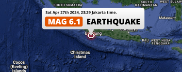
Strong M6.1 Earthquake hit in the Indian Ocean 129km from Bandung (Indonesia) on Saturday Evening.
Apr 27, 2024 11:29PM
Strong M6.1 Earthquake hit in the Indian Ocean 129km from Bandung (Indonesia) on Saturday Evening.
Christmas Island Earthquake Statistics
Average
A total of 183 earthquakes with a magnitude of four or above have struck within 300 km (186 mi) of Christmas Island in the past 10 years. This comes down to a yearly average of 18 earthquakes per year, or 1 per month. On average an earthquake will hit near Christmas Island roughly every 19 days.
A relatively large number of earthquakes occurred near Christmas Island in 2020. A total of 26 earthquakes (mag 4+) were detected within 300 km of Christmas Island that year. The strongest had a 5.2 magnitude.

Magnitude Distribution
The table below visualizes the distribution of all earthquakes that occurred within 300km of Christmas Island in the past 10 years. No earthquakes with a magnitude of 6 or above have occurred near Christmas Island during this time. Usually, higher magnitudes are less common than lower magnitudes. Small earthquakes with a magnitude below 4 on the Richter scale have been omitted from this overview.
| Magnitude | Earthquakes | Percentage |
|---|---|---|
| Mag. 4 | 170 | 92.9% |
| Mag. 5 | 13 | 7.1% |
| Mag. 6 | 0 | 0.0% |
| Mag. 7 | 0 | 0.0% |
| Mag. 8 | 0 | 0.0% |
| Mag. 9 | 0 | 0.0% |
| Mag. 10 | 0 | 0.0% |
Strongest earthquakes near Christmas Island
The strongest recent earthquake of the past 10 years near Christmas Island occurred on Nov 8, 2016 04:31 local time (Indian/Christmas timezone). It had a magnitude of 5.8 and struck 273 kilometers (170 mi) north-northwest of Flying Fish Cove, at a depth of 33 km. Discover more strong earthquakes near Christmas Island in the list below.
A longer time ago, a MAG-7.7 earthquake struck on Jul 17, 2006 15:19, 229 kilometers (142 mi) north-northwest of Flying Fish Cove. It is the strongest earthquake near Christmas Island in the past 124 years (Our data goes back to January 1st, 1900).
In the table below you will find the strongest earthquakes that occurred near Christmas Island in the past 10 years. You can use the tabs to find the heaviest historic earthquakes since the year 1900 or within a specific year or distance from Christmas Island.
Earthquakes by region of Christmas Island
Click the links below for earthquake reports for regions in Christmas Island.
Frequently Asked Questions
These questions are commonly asked in relation to earthquakes occurring near Christmas Island.
When was the last earthquake in Christmas Island?
A 3.3 magnitude earthquake hit near Christmas Island on the night of May 12, 2024 at 02:31 local time (Indian/Christmas). The center of this earthquake was located 300km north-east of Flying Fish Cove at a depth of 11km under water in the Indian Ocean. Check the list on our website for any earthquakes occurring near Christmas Island in the past hours.
What was the strongest earthquake near Christmas Island?
A 7.7 magnitude earthquake hit near Christmas Island on the afternoon of July 17, 2006 at 15:19 local time (Indian/Christmas). The center of this earthquake was located 229km north-east of Flying Fish Cove at a depth of 20km under water in the Indian Ocean. This is the strongest earthquake that occurred near Christmas Island since the year 1900.
How often do earthquakes occur near Christmas Island?
In the past 10 years, 183 earthquakes with a magnitude of four or higher occurred within a 300 kilometer range from Christmas Island. This averages to 18 earthquakes yearly, or one earthquake every 20 days.
